1972 American Geographical Society Map of Antarctica
SubmarineAntarctica-ags-1972$950.00


Title
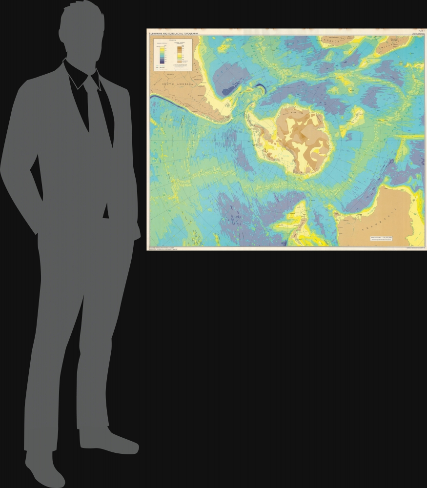
Submarine and Subglacial Topography.
1972 (dated) 32.5 x 41.25 in (82.55 x 104.775 cm) 1 : 15000000
1972 (dated) 32.5 x 41.25 in (82.55 x 104.775 cm) 1 : 15000000
Description
This is a 1972 American Geographical Society map of Antarctica depicting submarine and subglacial topography. Compiled by geologist Bruce Heezen and glaciologist Charles Bentley, this revolutionary map reveals the bizarrely shaped continent hidden under miles of Antarctic ice.
A Closer Look
Centered over Antarctica, the map employs a Polar Stereographic Conformal Projection. It includes South America as far north as Bolivia and Rio de Janeiro, the southernmost portion of Africa, nearly all of Madagascar, most of Australia, and all of New Zealand. Colors illustrate subglacial topography: some glaciers sit atop mountains over 3,000 meters high, while others, such as the Ross Ice Shelf, extend thousands of meters below sea level. Color details the sea floor surrounding Antarctica in all directions, reaching depths of over 7,000 meters. Islands in the Atlantic, Pacific, and Indian oceans are labeled, along with reefs, plateaus, trenches, and other formations. Both the Mid-Atlantic Ridge and the Mid-Indian Ocean Ridge are illustrated as well.Publication History and Census
This map was compiled by the American Geographical Society with submarine topography by Bruce C. Heezen and subglacial topography by Charles R. Bentley. We note 4 examples cataloged in OCLC: Columbia University, the Library of Congress, the Osher Map Library at the University of Southern Maine, and the University of California San Diego.CartographerS
The American Geographical Society (AGS) (1851 - Present) is an organization founded in in New York City 1851 by thirty-one New Yorkers. Organized to search for the lost Franklin Expedition, the search for Franklin proved unsuccessful. However, the AGS remained, and members played roles in surveying for the transcontinental railway and supported continued exploration efforts. Its main areas of focus were the Arctic, Antarctic, and Latin America and any exploration it sponsored was required to produce tangible scientific results. Today, after nearly 175 years, the AGS is still in operation and focuses its energy on promoting geographical education. More by this mapmaker...
Bruce Charles Heezen (April 11, 1924 - June 21, 1977) was an American geologist active at New York's Columbia University. Heezen was born in Viton, Iowa. He graduated from the University of Iowa in 1947 and went on to an MA (1952) and PhD (1957) at Columbia University. There he met the pioneering female geologist, Marie Tharp (1920 - 2006), with whom he collaborated to map the ocean's floors for some 30 years. Tharp was Heezen's assistant while he was a graduate student. When she showed Heezen that her plotting of the North Atlantic revealed a rift valley, Heezen dismissed it as 'girl talk'. She persisted and they eventually discovered that not only was there a North Atlantic rift valley, but a mountain range with a central valley that spanned the earth. Heezen died of a heart attack in 1977 while aboard the NR-1 submarine studying the Mid-Atlantic Ridge near Iceland. Learn More...
Charles Raymond Bentley (December 23, 1929 - August 19, 2017) was an American glaciologist and geophysicist. Bentley was born in Rochester, New York, into a family of lawyers. He attended Phillips Academy in Andover, Massachusetts, before enrolling at Yale, where he earned a degree in physics. His original idea was to study law, but his plans changed after he spent a summer working aboard a research ship in the Atlantic under the leadership of Maurice Ewing, an oceanographer from Columbia University. This revelation led Bentley to enroll at Columbia and study geophysics. During his time at Columbia, Bentley spent two summers working on the ice in Greenland, where he developed a seismic method for measuring ice depth. He successfully defended his dissertation in 1956. However, Bentley was awarded a spot on the United States Antarctic Expedition team, and left for Antarctica in 1957. He spent 25 months on the Antarctic ice, during which time he and the other members of the five-person team explored unknown parts of the Antarctic continent. They discovered a trench the size of Mexico and became the first team to successfully measure the ice sheet, which they discovered was as much 3,000 meters thick in places. It was only after returning from Antarctica that Bentley was notified that he had neglected to pay a $50 'disstertation fee'. Bentley joined the faculty at the University of Wisconsin-Madison in 1961 and became a giant in the field of glaciology. It is said that Bentley's 'first and foremost' concern after reaching the University of Wisconsin was 'training generations of glaciologists and geophysicists'. He made at least 15 trips to Antarctica during his seven decade career, including celebrating his 80th birthday on the ice during his last trip to Antarctica in 2009. Learn More...
Condition
Very good. Small area reinforced on verso. Soiling to top margin.
References
OCLC 799918835.