
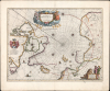
1640 / 1670 Blaeu Map of the Arctic Regions

This item has been sold.
Regiones Sub Polo Arctico.
Improving the map of the Arctic - new discoveries.
- Digital Map Information
- Suitable for large format printing
- Full resolution TIFF file
- ICC color profile embedded
- Delivered instantly via download link
Improving the map of the Arctic - new discoveries.
This is Willem Blaeu's 1640 map of the Arctic, in a beautiful example of the second state (with the superb dedicatory cartouche). Blaeu has here abandoned the speculative cartographic ideas about the North Pole region embraced by Mercator and Ortelius to produce an entirely new map based largely upon exploration and discovery.A Closer Look
The map covers from the north pole south as far as Nova Scotia, James Bay, Iceland, and Norway. The northern maritime coasts of Canada and Europe have been updated, as have the coasts of Greenland and the Arctic islands of Spitzbergen and Jan Mayen Island. Hudson's Strait and Bay are consistent with Hessel Gerritsz's mapping of the ill-fated Hudson Expedition, but include James' discoveries along the southern and western shores of the bay. Open passages at Port Nassau and at Sir James Lancaster's Sound on the west coast of Baffins Bay encourage the hope that a Northwest Passage might begin there. North of the mouth of Hudson's Strait, the 'Iland of good Fortuyn,' stands as a corruption of Frobisher's 'Loks Land Island' (named in no way for 'luck' but rather for Michael Lok, a 1570s London financier and one of Frobisher's patrons). The 'Isles of Resolution,' mapped first by Martin Frobisher, were renamed in 1612 by Sir Thomas Button, after his ship. Salisbury Island, Digges Islands, and 'Holde with hoope' (Akpatok Island), all derive from Gerritsz. Those unexplored Arctic lands surrounding the pole are left blank rather than filled with the quartet of speculative landmasses that characterized the maps of the 16th century. Zeno's fraudulent 'Frisland' is gone; even Zeno's 'Estotiland' on the coast of Labrador has been dispensed with, replaced instead with 'Terra de Cortelrealis'. Greenland and the lands to the north of Baffin Bay and to the West of James Button Bay fade away. Even the eastern shores of Nova Zembla and the northern shores of Spitzbergen are left unmapped. The southernmost island of the Svalbard Archipelago, Bear Island, appears and is named ('t Beren Eyland).An Uncatchable Bus, and other Phantom Islands
While Zeno's islands do not appear, other phantoms do. The erroneously sighted 'Sir Hugo Willoughby's Landt' appears at the mouth of the Barents Sea; Matsyn Island, thought to be a mischarted sighting of Nova Zemla, appears as well. In the absence of Frisland, Icaria, or Drogeo, Bus Island is marked southwest of Iceland. This island was recorded during the 1758 Third Frobisher Expedition by the Emanuel of Bridgwater. The Emanuel was a class of vessel known as a busse, and its crew thus named the island accordingly. Today, it is generally believed that the sighting resulted from misinterpreted optical effects. This did not prevent Thomas Shepard from claiming in 1671 to have explored the island. Discoverers repeatedly missed Bus despite the increase in Atlantic traffic in the 18th century: this resulted in later maps adjusting the size of the island down until its location was labeled 'site of sunken island' on 19th-century charts. In 1818, during his first Arctic expedition, John Ross sought the sunken island. Finding no sea floor in the region at 180 fathoms, he concluded that Bus did not exist at all.Decorative Engraving
In addition to its surprisingly frank geography, the map is beautifully engraved and richly decorative. The rhumb lines converging on the pole are distinctive themselves, but afford the placement of no fewer than 8 compass roses to indicate north. Four sailing ships appear: one near Spitsbergen, one near Bus Island, one at the mouth of Davis Strait, and one in Baffin's Bay. In the lower right, the cartouche containing the scales is decorated with two foxes, a bear, and a pair of Samoyed hunters (derived from Olearius' reports). The title cartouche - surrounded by clouds sprouting ten wind-heads - is flanked by a naked man devouring a joint of meat, and an iconographic representation of winter: an old man, bundled against the cold and holding a brazier for warmth. This second state of the map includes Joan Blaeu's dedication to Amsterdam mayor and VOC board member Willem Cornelisz Backer (1595 - 1652) and is embellished with his coat of arms.Publication History and Census
This map was engraved for inclusion in the Blaeu atlas in 1640, where it appeared without the dedicatory cartouche. Examples of the first state were inserted in atlases as late as 1643. In 1642, Joan Blaeu added the dedication to Guilelmo Backer, and this state appeared in the atlas until the firm was ruined by fire in 1672. There is an overlap in the use of both states between 1642 and 1643, suggesting that there was an unused stock of the first state. This example appeared in a c. 1670 German edition of Joan Blaeu's monumental Atlas Maior. The map appears on the market from time to time and is well represented in institutional collections.Cartographer
Willem Janszoon Blaeu (1571 - October 18, 1638), also known as Guillaume Blaeu and Guiljelmus Janssonius Caesius, was a Dutch cartographer, globemaker, and astronomer active in Amsterdam during the late 16th and early 17th centuries. Blaeu was born 'Willem Janszoon' in Alkmaar, North Holland to a prosperous herring packing and trading family of Dutch Reformist faith. As a young man, he was sent to Amsterdam to apprentice in the family business, but he found the herring trade dull and instead worked for his cousin 'Hooft' as a carpenter and clerk. In 1595, he traveled to the small Swedish island of Hven to study astronomy under the Danish Enlightenment polymath Tycho Brahe. For six months he studied astronomy, cartography, instrument making, globe making, and geodesy. He returned to Alkmaar in 1596 to marry and for the birth of his first son, Johannes (Joan) Blaeu (1596 – 1673). Shortly thereafter, in 1598 or 1599, he relocated his family to Amsterdam where he founded the a firm as globe and instrument makers. Many of his earliest imprints, from roughly form 1599 - 1633, bear the imprint 'Guiljelmus Janssonius Caesius' or simply 'G: Jansonius'. In 1613, Johannes Janssonius, also a mapmaker, married Elizabeth Hondius, the daughter of Willem's primary competitor Jodocus Hondius the Elder, and moved to the same neighborhood. This led to considerable confusion and may have spurred Willam Janszoon to adopt the 'Blaeu' patronym. All maps after 1633 bear the Guiljelmus Blaeu imprint. Around this time, he also began issuing separate issue nautical charts and wall maps – which as we see from Vermeer's paintings were popular with Dutch merchants as decorative items – and invented the Dutch Printing Press. As a non-Calvinist Blaeu was a persona non grata to the ruling elite and so he partnered with Hessel Gerritsz to develop his business. In 1619, Blaeu arranged for Gerritsz to be appointed official cartographer to the VOC, an extremely lucrative position that that, in the slightly more liberal environment of the 1630s, he managed to see passed to his eldest son, Johannes. In 1633, he was also appointed official cartographer of the Dutch Republic. Blaeu's most significant work is his 1635 publication of the Theatrum orbis terrarum, sive, Atlas Novus, one of the greatest atlases of all time. He died three years later, in 1638, passing the Blaeu firm on to his two sons, Cornelius (1616 - 1648) and Johannes Blaeu (September 23, 1596 - December 21, 1673). Under his sons, the firm continued to prosper until the 1672 Great Fire of Amsterdam destroyed their offices and most of their printing plates. Willem's most enduring legacy was most likely the VOC contract, which ultimately passed to Johannes' son, Johannes II, who held the position until 1617. As a hobbyist astronomer, Blaeu discovered the star now known as P. Cygni. Further Details...
Source
Blaeu, J., Atlas Major, Das ist, Welt-beschreibung, (Amsterdam: Blaeu) c. 1670.
In 1662 Joan Blaeu published his masterwork, which has been described as 'the greatest and finest atlas ever published' (Verwey, 1952): his monumental, eleven-volume Atlas Maior. This contained nearly six hundred maps, more than two hundred in excess of the Blaeus' mainstay the Atlas Novus. The former work already being renowned for the quality and beauty of its maps, Blaeu not only added copious material but improved the sophistication of his work: many of the newly-added maps utilized larger-sized presses and sheets, and the artistry applied to the engravings was often far superior to that of the earlier maps in the atlas - many of which by now were 30, and some more than 50 years old. Blaeu's Atlas Maior was published from 1662 to 1672, consisting of some 594 maps compiled into upwards of 9 volumes with some editions containing as many as 12 volumes. This triumphant work's publishing life was cut violently short when, in 1672, the Blaeu's mammoth workshop was destroyed by fire; surviving stock would be sold at auction between 1674 and 1677, occasionally appearing under the imprint of later Dutch printers such as Pieter Schenk and Pieter Mortier. The maps added to the Atlas Maior, owing to their tragically short publishing life, are among the hardest-to-find of the Blaeu maps.
Condition
Excellent. Generous margins.
References
OCLC 57436957. Burden, P., The Mapping of North America, #252.