This item has been sold, but you can get on the Waitlist to be notified if another example becomes available, or purchase a digital scan.
1883 Hassenstein Map of Sichuan and Yunnan Provinces, China
SudChina-hassenstein-1883$175.00

Title
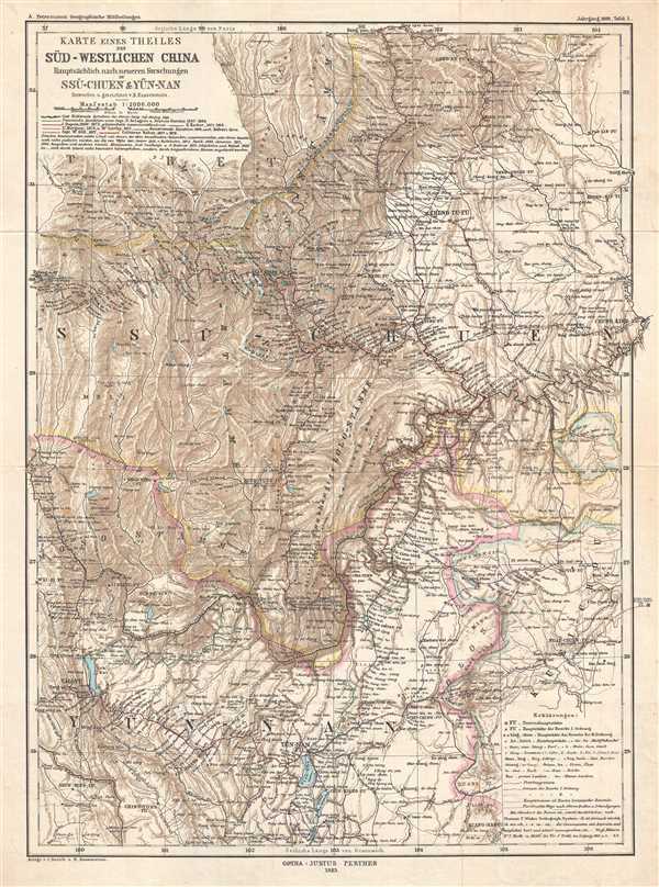
Karte Eines Theiles de Süd-Westlichen China Hauptsächlich nach neueren Forschungen in Ssu-chuen & Yün-nan
1883 (dated) 19.5 x 14.5 in (49.53 x 36.83 cm) 1 : 2000000
1883 (dated) 19.5 x 14.5 in (49.53 x 36.83 cm) 1 : 2000000
Description
This is an 1883 map of Sichuan and Yunnan Provinces in southwestern China by the German cartographer Bruno Hassenstein. The map depicts most both provinces, as well as parts of Tibet and Guizhou Province. The routes taken by several expeditions are illustrated on the map, beginning with Englishman Captain Thomas Wright Blakiston in 1861 and ending with the expeditions of fellow Englishman Edward Colborne Baber in 1877 and 1878. Myriad cities and towns are labeled, along with lakes and rivers. Mountains dominate approximately two thirds of the map. All text is in German.
Published by Petermanns Geographische Mitteilungen in Gotha in 1883.
Published by Petermanns Geographische Mitteilungen in Gotha in 1883.
Cartographer
Bruno Hassenstein (November 23, 1839 - August 27, 1902) was a German cartographer and was born in Ruhla, Thuringia. In 1854, Hassenstein began studying cartography and working under August Petermann in Gotha, founder of Petermanns Geographische Mitteilungen. Over the ensuing years, Hassenstein drew numerous maps for Petermanns Geographische Mitteilungen before relocating to Berlin in 1866 to work for another cartographer, including Karl Klaus von der Decken. He returned to Gotha two years later and works on maps for Henrich Theodor Menke's edition of Spurner's atlas of medieval history. He became editor of the cartography section of the Mittellungen in 1878 and worked on the Atlas von Japan, which was published in 1885. The University of Göttingen awarded him an honorary doctorate in 1878. More by this mapmaker...
Condition
Very good. Minor verso repair of a fold separation and minor closed margin tear professionally repaired on verso. Blank on verso.
References
OCLC 64637700.