This item has been sold, but you can get on the Waitlist to be notified if another example becomes available, or purchase a digital scan.
1659 Jansson Map of Sumatra, Malaya, and the Straits of Malacca (Singapore)
Sumatrae-jansson-1659$500.00

Title
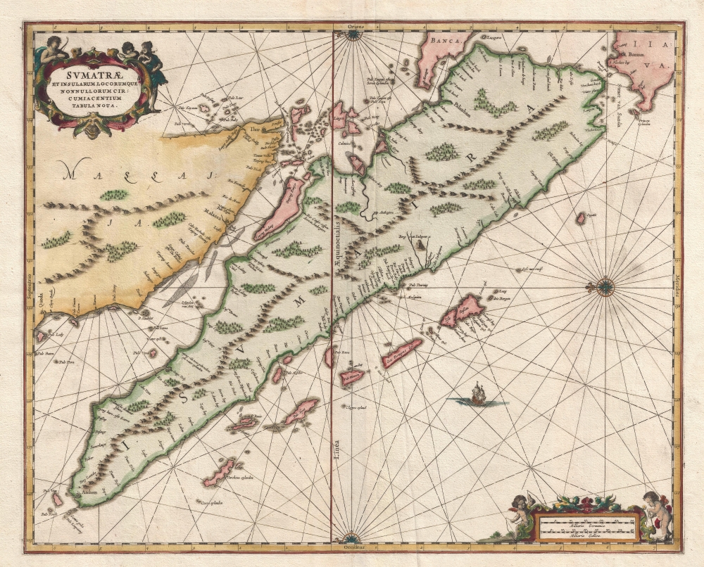
Sumatrae et Insularum Locorumque Nonnullorum Circumiacentium Tabula Nova.
1659 (undated) 17 x 21 in (43.18 x 53.34 cm) 1 : 3000000
1659 (undated) 17 x 21 in (43.18 x 53.34 cm) 1 : 3000000
Description
A stunning 1657 map of Malay, Sumatra, and the Straits of Malacca, including Singapore, prepared by Jan Jansson for the Waterwereld, the first printed Dutch sea atlas.
A Closer Look
Oriented to the East, the map is centered on the island of Sumatra, which it covers in its entirety. Also included are the Straits of Malacca, the southern parts of the Malay Peninsula, and the Strait of Sunda. The map names Senafur, a promontory just south of Ihor (Johor Baharu), which most scholars associate with modern day Singapore. The Strait of Malacca is clearly mapped with shallow areas noted. Several important points on the west coast of Malay, including Malacca and Johor (Ihor) are noted. On Sumatra numerous sites along the southwest coast are mapped but the only city identified is Aceh (Atchem).VOC Takes Malacca from Portugal
In 1644, the Dutch East India Company (VOC) seized control of Malacca, then the largest western port on the Malay Peninsula, from the Portuguese. In addition to the general goal of dominating the East India trade, they VOC planned to seize control of Malayan tin reserves. At the time, the central Malayan tin producing region was a vassal state of the powerful northern Sumatran Sultanate of Aceh. To counter Aceh, the VOC formed an alliance with Johore, a city-state near modern day Singapore. Not only did the alliance successfully wrest the Malayan tin region from Aceh, it also destabilized the Aceh sultanate in general, leading to a loss of political cohesion in Sumatra.Publication History and Census
This map did not appear in the 1650 first issue of Waterwereld. At the time, little was known of this part of the world, and what was known, was jealously guarded by Portuguese merchantmen and the ascendant Dutch East India Company (VOC). By 1657, when Jansson produced the second issue of Waterwereld, the VOC had stabilized their hold on the Straits of Malacca and started to leak geographical information. To accommodate the new geographical information about the East Indies, Jansson added three new maps to the second edition of his sea atlas, the Sumatra and the Malacca Strait (as here), Java, and Borneo. Original Jansson issues of the map from 1867, as here, are rare, but it was reissued by Pieter Schenk and Gerard Valk in 1710.Cartographer
Jan Jansson or Johannes Janssonius (1588 - 1664) was born in Arnhem, Holland. He was the son of a printer and bookseller and in 1612 married into the cartographically prominent Hondius family. Following his marriage he moved to Amsterdam where he worked as a book publisher. It was not until 1616 that Jansson produced his first maps, most of which were heavily influenced by Blaeu. In the mid 1630s Jansson partnered with his brother-in-law, Henricus Hondius, to produce his important work, the eleven volume Atlas Major. About this time, Jansson's name also begins to appear on Hondius reissues of notable Mercator/Hondius atlases. Jansson's last major work was his issue of the 1646 full edition of Jansson's English Country Maps. Following Jansson's death in 1664 the company was taken over by Jansson's brother-in-law Johannes Waesberger. Waesberger adopted the name of Jansonius and published a new Atlas Contractus in two volumes with Jansson's other son-in-law Elizée Weyerstraet with the imprint 'Joannis Janssonii haeredes' in 1666. These maps also refer to the firm of Janssonius-Waesbergius. The name of Moses Pitt, an English map publisher, was added to the Janssonius-Waesbergius imprint for maps printed in England for use in Pitt's English Atlas. More by this mapmaker...
Source
Jansson, J., Waterwereld, (Amsterdam: Jansson) 1657.
Condition
Very good. Original platemark visible.
References
OCLC 861737518. Van der Krogt, P. C. J., Koeman's Atlantes Neerlandici, (3 Vols), 8530:1. Suarez, Thomas, Early mapping of Southeast Asia, (Hong Kong: Periplus) p.207.