1710 Valk and Schenk Map of Sumatra, Malay, and Singapore
Sumatrae-valkschenk-1710$1,300.00

Title
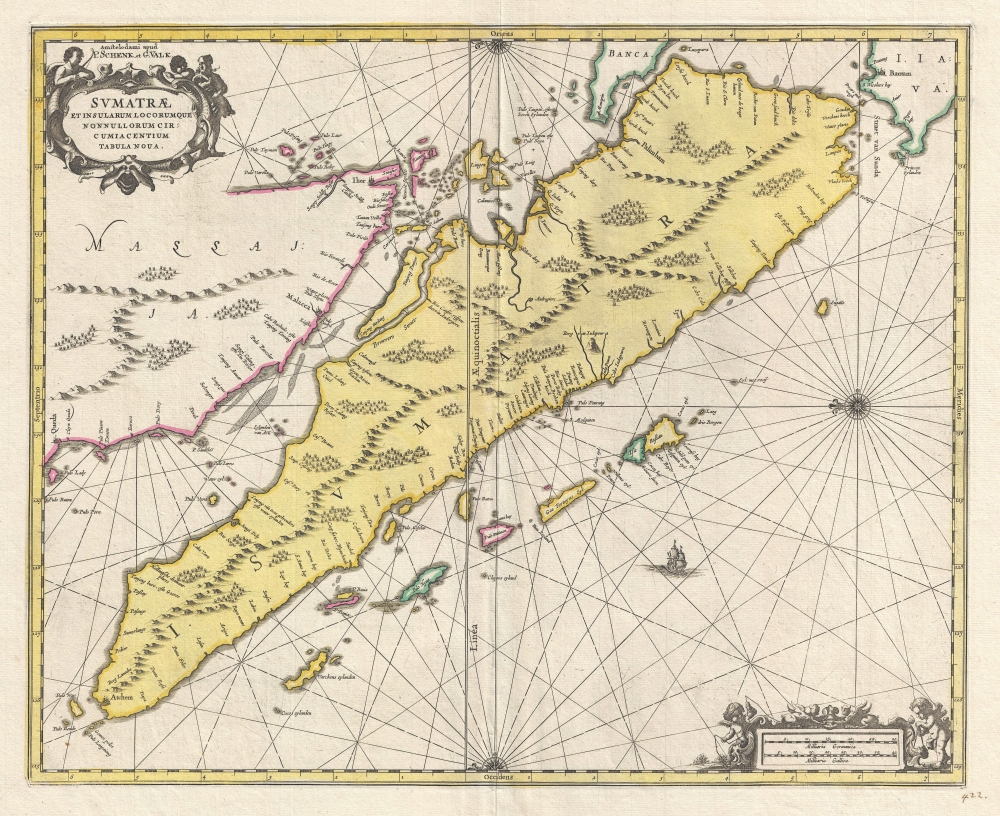
Sumatrae et Insularum Locorum que Nonnull Orum Circumiacentium Tabula Noua.
1710 (undated) 17 x 21 in (43.18 x 53.34 cm) 1 : 3000000
1710 (undated) 17 x 21 in (43.18 x 53.34 cm) 1 : 3000000
Description
A stunning full-color c. 1710 map of Sumatra, Malay, the straits of Malacca, and Singapore by Gerard Valk and Petrus Schenk under the imprint of Valk and Schenk.
A Closer Look
The map is oriented to the east with north on the left. While the map focuses on Sumatra, then an essential stop on the Dutch dominated Pepper Trade, it also depicts much of the surrounding region, including the critical Straits of Malacca, the southern Malay peninsula, and the Straits of Singapore, here identified as 'Nieuwe Straet.' Singapore Island does not appear as such, but a peninsula south of Johore is identified as 'Senasur,' clearly a precursor of 'Singapore'. The Strait of Malacca is mapped with shallow areas noted. Several important locations on the west coast of Malay, including Malacca and Jahore (Ihor), are noted. Numerous points along the southwest coast are mapped on Sumatra, but the only city identified is Aceh (Atchem).Dutch Interest
Around this time, the Netherlands became obsessed with this region. The VOC seized control of Malacca from the Portuguese in 1644 with an eye on Malay's rich tin deposits. The tin region was controlled by the Sultan of Aceh, who was unfriendly to the Dutch. In 1650, the Dutch allied with Johor in an attempt to disrupt shipping in the Straits of Malacca.Publication History
Like most maps by Valk and Schenk, this map is derived from either Joan Blaeu or Jan Jansson. Since both cartographers often issued nearly identical maps, it is hard to know who originated the cartography. Nonetheless, Valk and Schenk maps are derived from the Jansson plates, which the partners acquired in 1694.CartographerS
Gerard Valk (September 30, 1652 - October 21, 1726) (aka. Valck, Walck, Valcke), was a Dutch engraver, globe maker, and map publisher active in Amsterdam in the latter half of the 17th century and early 18th century. Valk was born in Amsterdam where his father, Leendert Gerritsz, was a silversmith. He studied mathematics, navigation, and cartography under Pieter Maasz Smit. Valk and moved to London in 1673, where he studied engraving under Abraham Blooteling (or Bloteling) (1634 - 1690), whose sister he married, and later worked for the map sellers Christopher Browne and David Loggan. Valke and Blooteling returned to Amsterdam in 1680 and applied for a 15-year privilege, a kind of early copyright, from the States General, which was granted in 1684. In 1687, he established his own firm in Amsterdam in partnership with Petrus (Pieter) Schenk, who had just married his sister, Agata. They published under the imprint of Valk and Schenk. Also, curiously in the same year Valk acquired the home of Jochem Bormeester, also engraver and son-in-law of art dealer Clement De Jonghe. Initially Valk and Schenk focused on maps and atlases, acquiring the map plates of Jodocus Hondius and Jan Jansson in 1694. Later, in 1701 they moved into the former Hendrick Hondius (the younger) offices where they began producing globes. Valk and Schenk soon acquired the reputation of producing the finest globes in the Netherlands, a business on which they held a near monopoly for nearly 50 years. In 1702, Valk joined the Bookseller's Guild of which he was promptly elected head. Around the same time, Gerard introduced his son, Leonard, who was married to Maria Schenk, to the business. Leonard spearheaded the acquisition of the map plates of Frederick de Wit in 1709. Nonetheless, Leonard was nowhere near as sophisticated a cartographer or businessman as his father and ultimately, through neglect, lost much the firm's prestige. After his death, the firm was taken over by his widow Maria. More by this mapmaker...
Petrus Schenk (Pieter Schenck) the Elder (December 26, 1660 - 1711) was a Dutch engraver, globe maker, and map publisher active in Amsterdam and Leipzig in the latter half of the 17th century. Schenk, was born in Elberfield, Germany. He moved in Amsterdam in 1675, becoming the apprentice to Gerard Valk (Valck). In 1687, Schenk married Agatha Valk, Gerard Valk's sister and went into partnership with his brother-in-law under the imprint of 'Valk and Schenk'. Initially they focused on maps and atlases, acquiring the map plates of Jan Jansson and Jodocus Hondius in 1694. Later, in 1701 they moved into the former Hondius offices where they began producing globes. Valk and Schenk quickly became known for producing the best globes in the Netherlands, a business on which they held a near monopoly for nearly 50 years. Schenk's three sons, Pieter Schenk the Younger, Jan Schenk, and Leonard Schenk, all became engravers in their own right. Pieter Schenk the Younger inherited the business and ran his father's shop in Leipzig. His daughter, Maria Schenk, married Leonard Valk, the son of Gerard Valk, and continued to run the Valk and Schenk map engraving workshop in Amsterdam. Learn More...
Jan Jansson or Johannes Janssonius (1588 - 1664) was born in Arnhem, Holland. He was the son of a printer and bookseller and in 1612 married into the cartographically prominent Hondius family. Following his marriage he moved to Amsterdam where he worked as a book publisher. It was not until 1616 that Jansson produced his first maps, most of which were heavily influenced by Blaeu. In the mid 1630s Jansson partnered with his brother-in-law, Henricus Hondius, to produce his important work, the eleven volume Atlas Major. About this time, Jansson's name also begins to appear on Hondius reissues of notable Mercator/Hondius atlases. Jansson's last major work was his issue of the 1646 full edition of Jansson's English Country Maps. Following Jansson's death in 1664 the company was taken over by Jansson's brother-in-law Johannes Waesberger. Waesberger adopted the name of Jansonius and published a new Atlas Contractus in two volumes with Jansson's other son-in-law Elizée Weyerstraet with the imprint 'Joannis Janssonii haeredes' in 1666. These maps also refer to the firm of Janssonius-Waesbergius. The name of Moses Pitt, an English map publisher, was added to the Janssonius-Waesbergius imprint for maps printed in England for use in Pitt's English Atlas. Learn More...
Condition
Very good. Original centerfold. Wide original margins. Platemark visible. Old color.
References
Van der Krogt, P. (Atlantes) 8530:1. OCLC 36189613. Suárez, T., Early Mapping of Southeast Asia, p. 207.