1716 Homann Map of Sweden at the End of the Age of Greatness
Sweden-homann-1716$600.00

Title
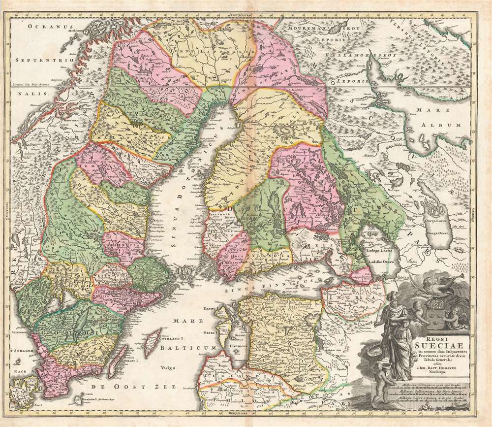
Regni Sueciae in omnes suas Subjacentes Provincias accurate divisi Tabula Generalis edita à Ioh. Bapt. Homanno Noribergae.
1716 (undated) 19.25 x 22.5 in (48.895 x 57.15 cm) 1 : 3200000
1716 (undated) 19.25 x 22.5 in (48.895 x 57.15 cm) 1 : 3200000
Description
This is a richly colored example of Johan Baptist Homann's c. 1716 map of the Kingdom of Sweden, which brought what was the dominant mapping of Sweden and its neighbors up-to-date with the events of the Great Northern War. Homann started - almost certainly - with Frederic de Wit's 1680 Regni Sueciae but added detail and place names that did not exist prior to the 1700–1721 Great Northern War between Sweden and Russia, and particularly before the 1703 capture of the island of Kotlin by Russia from Sweden, the 1703 Russian capture of Nyenskans, and the foundation of the city of St. Petersburg. The city of Oresca, also known as Oreshek, was captured by Russia in 1702 and renamed Schlüsselburg by Peter the Great during his administrative reforms. Here it retained its earlier name.
Moreover, the waters are muddied by the existence of no fewer than five maps, printed from four different plates, all with the same title, all attributed to Homann, although several of these appear to be pirated maps, copying the Homann down to its Imperial Privilege. The earliest credible date we associate with one of these is 1715. The present example conforms to the example in Rumsey dated 1716.
The Great Northern War
This map was produced during the 1700–1721 Great Northern War between Sweden and Russia and captures a period in which Sweden was losing ground in the conflict - particularly in the region of the Gulf of Finland, and the city of St. Petersburg. The dotted, engraved border between Russian and Swedish territory is preserved here from (most likely) De Wit's 1680 Regni Sueciae Tabula Generalis, which showed the extent of Sweden's acquisitions as of 1654 or thereabouts. But the details of the map, particularly in the vicinity of Carelia and Ingra, show little to celebrate on the part of the Swedish. Many of the border areas between Sweden and Russia shown here were, at best, contested - and many were, by the time this map was published, securely Russian. Livonia, Ingria, and Karelia are here no longer Swedish, and the newly founded city of Petersburg is clearly marked.The Allegorical Cartouche
In the lower right is an attractive cartouche. Two putti display the Swedish three-crowned arms, and a winged victory, or fame, blows her horn overhead. Ares and Minerva look on from the side, having not yet entirely forsaken Sweden (despite Charles XII's crushing 1709 defeat at Poltava, which almost certainly predated this map). We confess bafflement at the child with a plate of fish in the foreground.Publication History and Census
The cataloging of this map is wildly inconsistent in terms of its dating. Many libraries list it with a date of 1702, despite the clear presence of the city of Petersburg. This is not credible: in 1703 Peter and Paul Fortress had only just been laid down. Tsar Peter would move his capital from Moscow to Saint Petersburg in 1712, and the very first plan of the city would not be published until 1717.Moreover, the waters are muddied by the existence of no fewer than five maps, printed from four different plates, all with the same title, all attributed to Homann, although several of these appear to be pirated maps, copying the Homann down to its Imperial Privilege. The earliest credible date we associate with one of these is 1715. The present example conforms to the example in Rumsey dated 1716.
CartographerS
Johann Baptist Homann (March 20, 1664 - July 1, 1724) was the most prominent and prolific map publisher of the 18th century. Homann was born in Oberkammlach, a small town near Kammlach, Bavaria, Germany. As a young man, Homann studied in a Jesuit school and nursed ambitions of becoming a Dominican priest. Nonetheless, he converted to Protestantism in 1687, when he was 23. It is not clear where he mastered engraving, but we believe it may have been in Amsterdam. Homann's earliest work we have identified is about 1689, and already exhibits a high degree of mastery. Around 1691, Homann moved to Nuremberg and registered as a notary. By this time, he was already making maps, and very good ones at that. He produced a map of the environs of Nürnberg in 1691/92, which suggests he was already a master engraver. Around 1693, Homann briefly relocated to Vienna, where he lived and studied printing and copper plate engraving until 1695. Until 1702, he worked in Nuremberg in the map trade under Jacob von Sandrart (1630 - 1708) and then David Funck (1642 - 1709). Afterward, he returned to Nuremberg, where, in 1702, he founded the commercial publishing firm that would bear his name. In the next five years, Homann produced hundreds of maps and developed a distinctive style characterized by heavy, detailed engraving, elaborate allegorical cartouche work, and vivid hand color. Due to the lower cost of printing in Germany, the Homann firm could undercut the dominant French and Dutch publishing houses while matching their diversity and quality. Despite copious output, Homann did not release his first major atlas until the 33-map Neuer Atlas of 1707, followed by a 60-map edition of 1710. By 1715, Homann's rising star caught the attention of the Holy Roman Emperor Charles VI, who appointed him Imperial Cartographer. In the same year, he was also appointed a member of the Royal Academy of Sciences in Berlin. Homann's prestigious title came with several significant advantages, including access to the most up-to-date cartographic information as well as the 'Privilege'. The Privilege was a type of early copyright offered to very few by the Holy Roman Emperor. Though less sophisticated than modern copyright legislation, the Privilege offered limited protection for several years. Most all J. B. Homann maps printed between 1715 and 1730 bear the inscription 'Cum Priviligio' or some variation. Following Homann's death in 1724, the firm's map plates and management passed to his son, Johann Christoph Homann (1703 - 1730). J. C. Homann, perhaps realizing that he would not long survive his father, stipulated in his will that the company would be inherited by his two head managers, Johann Georg Ebersberger (1695 - 1760) and Johann Michael Franz (1700 - 1761), and that it would publish only under the name 'Homann Heirs'. This designation, in various forms (Homannsche Heirs, Heritiers de Homann, Lat Homannianos Herod, Homannschen Erben, etc.) appears on maps from about 1731 onwards. The firm continued to publish maps in ever-diminishing quantities until the death of its last owner, Christoph Franz Fembo (1781 - 1848). More by this mapmaker...
Anders Bure (August 14, 1571 - February 4, 1646) was a Swedish mathematician and cartographer. He is considered the father of Swedish cartography. He was the son of the parish priest Engelbertus Laurentii and Elisabeth Andersdotter Burea, descendant of the long-established Bureätten family. His immediate family included diplomats and government officials. His education is obscure, though he is mentioned as an office clerk in 1602. His duties in the following years involved recording royal genealogical and historical works, involving him in the highest echelons of Swedish society. He also participated in diplomatic assignments, including missions to both Russia and Finland. His cartographic contributions improved the mapping both of the northern parts of Sweden, and the kingdom as a whole. His six-sheet 1626 Orbis Arctoi represented the first real improvement to the mapping of the northern parts of Europe since the Olaus Magnus map of the previous century: this map would provide the basis for virtually every European map of Scandinavia to follow in the 17th century. In addition to these achievements, he was the first person recorded to use the decimal system in Sweden. Learn More...
Source
Homann, J. B., Neuer Atlas bestehend in einig curieusen Astronomischen Kuppren und vielen auserlesenen accuratensten Land-Charten über die Gantze Welt, (Nuremberg: Homann), 1716.
Homann's Neuer Atlas bestehend in einig curieusen Astronomischen Kuppren und vielen auserlesenen accuratensten Land-Charten über die Gantze Welt was first publihsed in 1707 with 33 maps. A second edition followed in 1710 with 60 maps. Subsequent editions followed until about 1730. The title page notes proudly that the atlas features measurements based on the 'Copernican principle of the moving sky', a truly state-of-the-art innovation for the period. Regardless of editions, collations of the atlas are inconsistent, with some examples having less, while others have more maps - a consequence of the fact that the map sheets were delivered loose, to be bound at the buyer's discretion, and so some buyers chose to omit maps they did not consider relevant, or add others they did. Between editions, the constituent maps, particularly of European regions, were regularly updated to reflect the most recent political events. The atlas continued to be published by Homann's son, J. C. Homann (1703 - 1730), and then by Homann Heirs. Most examples also feature a fine allegorical frontispiece with the title Atlas Novus Terrarum Orbis Imperia, regna et Status, which was used for multiple Homann atlases, including the Neuer Atlas and the Atlas Minor.
Condition
Very good. Bright and attractive original hand color. toning along centerfold, else excellent.
References
cf. Rumsey 12499.181. OCLC 165631355.