This item has been sold, but you can get on the Waitlist to be notified if another example becomes available, or purchase a digital scan.
1938 Swiss Tourism Office View of Switzerland
SwitzerlandView-tourismoffice-1938$125.00


Title
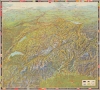
Mapa de Suíza a vista de pájaro.
1938 (dated) 23.5 x 21 in (59.69 x 53.34 cm)
1938 (dated) 23.5 x 21 in (59.69 x 53.34 cm)
Description
A gorgeous 1938 bird's-eye view map of Switzerland, designed by Otto Betschmann and published by the Swiss National Tourism Office. It contains many interesting features, not least of which are blotted out German and Austrian flags along those countries' borders with Switzerland.
Interestingly, German and Austrian flags at border crossings have been obscured, which may easily have been a reflection of the makers' political leanings; there was very little support for Nazism in Switzerland and the country was fiercely committed to protecting its independence. It may also reflect uncertainty over the future status of Austria given the Anschluss in March 1938. One wonders if the German edition of the map also obscures these flags.
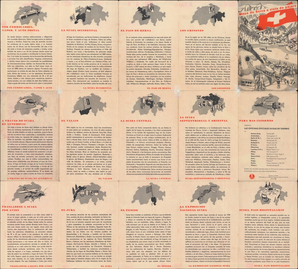
The border of the map includes flags of various countries with the name of Switzerland in that county's language written out. Text on the verso in Spanish discusses the history of Switzerland and its various regions, information on transportation, locations of offices of the National Tourism Office, and a title panel with an illustration. The design of the view allowed for the text on the verso to be changed out to different languages and distributed to different office locations accordingly (at least a French and German edition existed, in addition to the present Spanish one).
A Closer Look
Oriented towards the north, this remarkable view takes in the entire Western Alps region, from Lac Léman (Lake Geneva) and Lac de Neuchâtel on the French-Swiss border in the west to Lake Constance (Bodensee) and Trentino-Alto Adige in the east. In the foreground lies Milan and the relatively flat lands of northern Italy, while the horizon stretches to include Bavaria, the Rhine Valley, and even Berlin, Paris, Brussels, and London. Numerous towns, mountains, and lakes are labelled. A minimalist legend at bottom right indicates the means of representing railways, roads, ferries, airports, and border crossings.Interestingly, German and Austrian flags at border crossings have been obscured, which may easily have been a reflection of the makers' political leanings; there was very little support for Nazism in Switzerland and the country was fiercely committed to protecting its independence. It may also reflect uncertainty over the future status of Austria given the Anschluss in March 1938. One wonders if the German edition of the map also obscures these flags.
The border of the map includes flags of various countries with the name of Switzerland in that county's language written out. Text on the verso in Spanish discusses the history of Switzerland and its various regions, information on transportation, locations of offices of the National Tourism Office, and a title panel with an illustration. The design of the view allowed for the text on the verso to be changed out to different languages and distributed to different office locations accordingly (at least a French and German edition existed, in addition to the present Spanish one).
Publication History and Census
This view was published by the Swiss National Tourism Office (Oficina Nacional Suíza de Turismo) in 1938. It was designed by Otto Betschmann and printed by Kümmerly and Frey in Bern. The only known examples of this view in institutional collections are a French edition ('Carte de la Suisse a vol d'oiseau') held by the Zentralbibliothek Zürich and a German edition ('Vogelschaukarte der Schweiz') held by the Library of Congress and the Staatsbibliothek zu Berlin.CartographerS
Otto Betschmann (1884 - 1959) was a Swiss artist and painted known for his bird's eye views known as Aerovue-Karten, which combined a 'normal' orthogonal map projection with three-dimensional topographic features, an approach well-suited to depicting the mountainous terrain of Switzerland. Most of his works dealt with his native country and locales therein. More by this mapmaker...
Hermann Kümmerly (September 6, 1857 - April 29, 1905) was a Swiss painter, lithographer, and cartographer. Kümmerly was born in Bern. He apprenticed as a lithographer under his father Gottfried, and also studied as a painter. He worked for a time for the Swiss Confederation's Topographic Bureau, which did not have its own printing company. In conjunction with Rudolf Leuzinger, the Kümmerly printing office gradually specialized in map printing. His maps became renowned for their vivid and accurate presentation of topography and in his naturalistic use of color in maps. He became particularly well known for his large school wall map of Switzerland, which has been hanging in virtually every school in Switzerland from 1903 until today. In 1898, his brother-in-law Otto Julius Frey joined the company as cartographer and co-owner, who now took the name Kümmerly and Frey. In 1931, Walter Kümmerly and Max Frey, the sons of the two predecessors, took over the management and skillfully steered the company through the years of crisis and World War II, despite the prohibition on map printing. In the post-war period, production shifted back to map production and book production with geographic themes. Since 1980, the fourth generation has been represented in the company management with Barbara Elisabeth Peters. Learn More...
Condition
Very good. Wear along fold lines with 'pinholes' at fold intersections professionally repaired on verso.
References
OCLC 1393276962 (French edition), 5500281 (German edition).