
This item below is out of stock, but another example (left) is available. To view the available item, click "Details."
Details
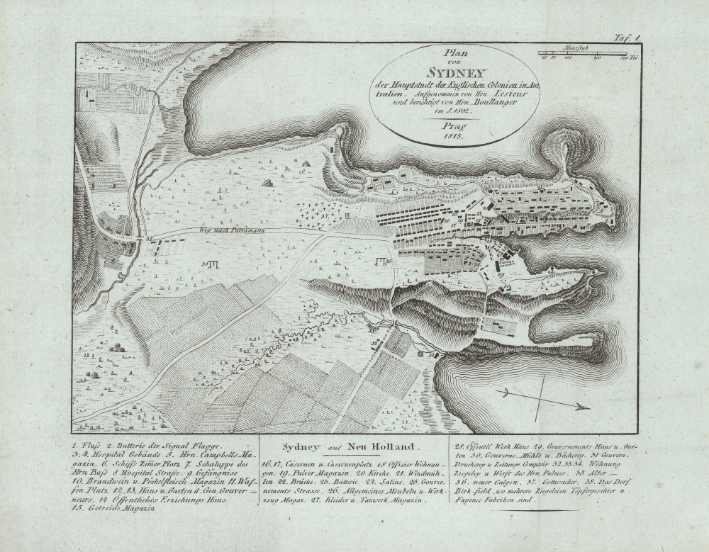
1815 Lesueur / Boullanger Map of Sydney, New South Wales, Australia
$950.00
1815 Lesueur / Boullanger Map of Sydney, New South Wales, Australia
Sydney-lesueur-1815-2$475.00

Title
Plan von Sydney der Hauptstadt der Englischen Colonien in Australien. Aufgenommen von Hrn. Lesueur; und berichtigt von Hrn Boullanger i. J. 1802.
1815 (dated) 7 x 9 in (17.78 x 22.86 cm) 1 : 18000
1815 (dated) 7 x 9 in (17.78 x 22.86 cm) 1 : 18000
Description
One of the earliest obtainable maps of the city of Sydney, Australia, this is an 1815 German edition of an 1802 manuscript map by Charles-Alexandre Lesueur. The map covers from Darling Harbour to Dawes Batter and from Woolloomooloo to Brickfields. At the bottom of the plan there is a numbered index identifying thirty-eight important buildings. In addition, the map note roads, buildings, windmills, gardens, orchards, gallows, brickfields, and the cemetery.
A Closer Look
The manuscript on which this map is based survives in the collections of the Museum d'Histoire Naturelle, in Le Havre, France. Lesueur accompanied the Napoleon sponsored expedition of Nicolas Baudin, which sailed from Le Havre on October 19, 1800. Initially he signed on as an assistant gunner, but his skills at drawing, mathematics, and scientific observation were promptly recognized leading him to be reassigned as the ship's 'artist' and 'assistant naturalist.' Although Lesueur is commonly credited with the authorship of this map, he more likely simply assisted in the illustration of a map prepared by Charles Pierre Boullanger, a midshipman on the same vessel. In this example's title area, Boullanger is credited with 'correcting' the map, but we suspect this ghosts over his actual deeper involvement. The French and English were at this time in the midst of the Napoleonic Wars, and we can only imagine that the British must have felt considerable trepidation as their militarily sensitive harbor was mapped by a government sponsored French expedition.Publication History and Census
The map was first engraved by Jean Baptiste Antoine Cloquet and printed in the 1802 French edition of Francois Peron's Voyage de decouvertes aux terres Australes. The work proved popular and subsequent editions followed in French, English, and German. The present example is the 1815 German edition. It was published by Geographischen Institutes of Weimer and is one of that organization's earliest and most significant publications.CartographerS
Charles Alexandre Lesueur (January 1, 1778 - December 12, 1846) was a French naturalist, artist, and explorer active in the early 19th century. In 1801 Lesueur signed on as a gunner in the Napoleon sponsored expedition of Nicolas Baudin. Early in the voyage Lesueur was recognized as a fine artist and keen observer and, after the death of the expedition's zoologist Rene Mauge, he was promoted to 'assistant naturalist' under Francois Peron. Most of the important sketches surviving from the Baudin expedition are the work of Lesueur. Cartographically he is known for two important plans of Sydney, Australia, among the first made. Following the expedition he relocated to New Harmony, Indiana, United States where he lived from 1815 to 1833. He was in New Harmony when Prince Maximilian, Prince of Wied-Neuweid, Germany, and artist Karl Bodmer came to spend five months there in 1832–1833. Prince Maximilian said of Lesueur "He had explored the country in many directions, was acquainted with everything remarkable, collected and prepared all interesting objects and had already sent considerable collections to France" (Elliott & Johansen, p. 6). In 1837 Lesueur returned to his home town of La Harve, France, where he was appointed curator of the Musee d'Histoire Naturelle du Havre. There he died in 1846. More by this mapmaker...
Geographisches Institut, Weimar (fl. 1804 - c. 1903) was a German map and globe publishing house and geographical research institute based in Weimar. The organization primarily focused on republishing and improving upon the works of earlier cartographers, including Kitchin, Jefferys, Carey, and others. In general, its publications are known for their fine engraving, attention to detail, historical accuracy, and overall high quality. The firm was founded in 1804 by Friedrich Justin Bertuch (???? - c. 1845) and, on his death, passed to his son Robert Froreip (???? - 1855), then to Louis Denicks of Luneberg, then in 1859 to Voigt & Günther, in 1883 to F. Arnd, from 1890 - 1893 to Julius Kettler, and in 1903 to Max Wedekind. During the institute's height in the early 19th century, most of its cartographic publication was overseen by Carl Ferdinand Weiland (1782 - 1847). The firm also employed the cartographers Franz Xaver von Zach, Adam Christian Gaspari, Heinrich Kiepert, Karl (or Carl) and Adolf Graef, Julius Kettler, Carl Riemer and Karl Christian Bruhns. Weimar was a logical place for a collective like the Geographisches Institut to arise; it was a cultural mecca in the German-speaking world in the late 18th and 19th centuries because of its liberal atmosphere and associations with figures like Schiller, Herder, and, above all, Goethe, who spent most of his adult life in the city. Learn More...
Condition
Very good. Minor wear and verso reinforcement along original fold lines. Light soiling.
References
Perry, T and Prescott, J. F., A Guide to Maps of Australia in Books Published 1780 - 1830, 1808.3. Bonnemains, J., Forsyth, E., Smith, B., Baudin in Australian Waters, 16074.3. McCormick, Tim, First Views of Australia, 1788- 1825: A history of early Sydney, no. 62.