This item has been sold, but you can get on the Waitlist to be notified if another example becomes available, or purchase a digital scan.
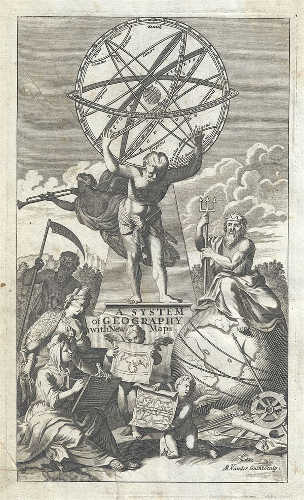
1701 Moll Title Page for a System of Geography (showing armillary sphere)
SystemOfGeography-moll-1701$75.00

Title
A System of Geography with New Maps.
1701 (undated) 10 x 6 in (25.4 x 15.24 cm)
1701 (undated) 10 x 6 in (25.4 x 15.24 cm)
Description
This is a beautiful diagram of an Armillary Sphere which appears as the title page to Herman Moll's System of Geography. It depicts Atlas, the titan of astronomy and navigation in Greek mythology, holding the armillary sphere. Neptune, the God of the Sea is shown sitting on a globe, while other Gods and Goddesses look on. Two cherubs are seen holding up world maps. The Armillary Sphere is an old astronomical observation device used to differentiate between the Ptolemaic system and the Copernican system, by displaying the relationship between the various objects in the sky. The illustration here depicts the central terrestrial globe with rings representing the main celestial circles. This beautiful title page was engraved by M. Vander Gucht and issued as the title page to Herman Moll's 1701 edition of A System of Geography.
Cartographer
Herman Moll (1654 - 1732) was an important 18th century map publisher and engraver based in London and Holland. Moll's origins are disputed with some suggesting he was born in the Netherlands and others Germany - the Moll name was common in both countries during this period. Most likely Moll was a German from Bremen, as his will, friends, and contemporaries suggest. What is known for certain is that he moved to London in 1678, possibly fleeing the Scanian War, where he worked as an engraver for Moses Pitt and other London map publishers. Around the turn of the century, Moll set up his own shop where he produced a large corpus of work known for its high quality and decorative flair. As a new émigré to England, Moll made himself more English than the English, and through his cartography proved a fierce advocate for his adopted nation. Most of Moll's early maps were issued as loose sheets that would be bound to order, however, he did publish several important atlases late in his career. Moll is said to have made the bold claim that without a doubt "California is an Island" and that he "had in [his] office mariners who have sailed round it." While California may not be an island (yet), it is true that Moll had talent for attracting interesting friends and acquaintances. He frequented London's first stock exchange, Jonathan's Coffeehouse at Number 20 Exchange Alley, Cornhill. At the time Jonathan's was known as "a place of very considerable concourse for Merchants, sea faring Men and other traders" (Erleigh, The Viscount, The South Sea Bubble, Manchester: Peter Davies, Ltd., 1933, 21). Eventually this activity attracted the interest of stock brokers, who inspired by sailor's tales, sponsored the ill-fated South Sea Company, the world's first stock bubble. Moll's close circle, mostly from the Coffee House, included scientist Robert Hooke, the writers Daniel Defoe (Robinson Crusoe) and Jonathan Swift (Gulliver's Travels), the pirates William Dampier, William Hacke and Woodes Rogers, and the archeologist William Stukeley. Herman Moll's work was highly regarded for its decorative beauty and was pirated, most notably by the Irish publisher George Grierson, both in his lifetime and after his 1732 death at St. Clement Danes, London. More by this mapmaker...
Source
Moll, H., A System of Geography: Or, A New and Accurate Description of the Earth In all its Empires, Kingdoms and States (London), 1701.
Condition
Very good. Minor creasing and toning with some spotting at places. Original platemark visible. Pasted on paper, as issued.