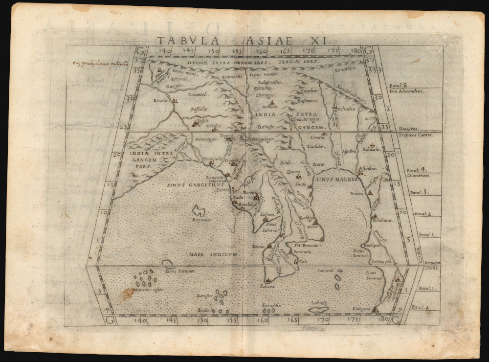
1561 Ruscelli/ Ptolemy Map of Southeast Asia
TabulaAxiaeXI-ruscelli-1561$350.00

Title
Tabula Asiae XI.
1561 (undated) 7.25 x 9.25 in (18.415 x 23.495 cm) 1 : 32000000
1561 (undated) 7.25 x 9.25 in (18.415 x 23.495 cm) 1 : 32000000
Description
This is a handsome example of Girolamo Ruscelli's 1561 / 1574 map of Southeast Asia and the Malay Peninsula. The region was known to ancient geographers as 'India Extra Gangem,' or 'India Beyond the Ganges'.
A Closer Look
The map thus embraces Thailand, Burma, and Vietnam, reaching from the tip of the Malay Peninsula to the Himalayas in the north. The Ganges River is clearly shown and named. The Aurea chersonensis (the Malay Peninsula, possibly inclusive of Sumatra) and Aurea regio (Burma, generally) speak to the allure the region held to European armchair explorers (Aurea = Golden.). The map portrays two bodies of water, both with an array of named islands: the Indian Ocean (Mare Indicum) and the Sinus Magnus (the Great Bay). Beyond the Great Bay to the east is another coastline. This, according to Ptolemy's geography, was China.Cartographic Context
Ptolemy considered the Indian Ocean to be an inland sea, with the southern part of Africa continuing eastward to meet China beyond the Malay peninsula. The Sinus Magnus was the body of water enclosed by Malay Peninsula and the landmass encircling the whole of the Indian Ocean. Certainly, the modern maps included in the editions of Ptolemy produced by Ruscelli and his contemporaries showed that by this time it was well understood that such a 'land bridge' between Africa and China did not exist - although some early mapmakers speculated that the eastern shore of the Sinus Magnus might actually have been the newly-discovered American Pacific coastline. The city of Cattigara, appearing in the extreme southeast of the present map, can be found on the South American coastline on the 1540 Münster America and the Oronce Fine world map produced the same year.Ancient Cartography Revisited
Ruscelli's La geografia di Claudio Tolomeo Alessandrino was firstly a definitive edition of Ptolemy's ancient geographical text, and so Ruscelli's 16th-century maps shared a binding with maps like this one which reflected 2nd-century geographical knowledge. Ruscelli was not the only late Renaissance geographer to publish Ptolemy's work. The ancient maps in this edition were largely derived from the works issued by Giacomo Gastaldi in 1548, which in turn was much derived from Sebastian Münster's work of 1540.Publication History and Census
The map was engraved by Giulio Sanuto for inclusion in Ruscelli's 1561 La geografia di Claudio Tolomeo Alessandrino, and the plate appeared in all editions of that work. The separate map is cataloged in 9 institutional collections, although it does appear on the market from time to time. The maps of the 1561 edition were engraved two-to-a-plate, and consequently, the platemark runs off the edge of the sheet at top for the 1561, 1562 and 1564 printings. Afterward, the plates were divided, and examples from 1574 onwards, as here, exhibit a platemark all around the map; furthermore, the plate shows considerable evidence of reworking, in many cases simplifying the form of the mountains to improve clarity. In 1599, letterpress was added to the upper border. The present example conforms typographically to the 1574 edition. We see about ten examples of this separate map cataloged in OCLC, in various editions.CartographerS
Girolamo Ruscelli (1500 - 1566) was an Italian polymath, humanist, editor, and cartographer active in Venice during the early 16th century. Born in Viterbo, Ruscelli lived in Aquileia, Padua, Rome and Naples before relocating to Venice, where he spent much of his life. Cartographically, Ruscelli is best known for his important revision of Ptolemy's Geographia, which was published posthumously in 1574. Ruscelli, basing his work on Gastaldi's 1548 expansion of Ptolemy, added some 37 new "Ptolemaic" maps to his Italian translation of the Geographia. Ruscelli is also listed as the editor to such important works as Boccaccio's Decameron, Petrarch's verse, Ariosto's Orlando Furioso, and various other works. In addition to his well-known cartographic work many scholars associate Ruscelli with Alexius Pedemontanus, author of the popular De' Secreti del R. D. Alessio Piemontese. This well-known work, or "Book of Secrets" was a compilation of scientific and quasi-scientific medical recipes, household advice, and technical commentary on a range of topics that included metallurgy, alchemy, dyeing, perfume making. Ruscelli, as Alexius, founded a "Academy of Secrets," a group of noblemen and humanists dedicated to unearthing "forbidden" scientific knowledge. This was the first known experimental scientific society and was later imitated by a number of other groups throughout Europe, including the Accademia dei Secreti of Naples. More by this mapmaker...
Claudius Ptolemy (83 - 161 AD) is considered to be the father of cartography. A native of Alexandria living at the height of the Roman Empire, Ptolemy was renowned as a student of Astronomy and Geography. His work as an astronomer, as published in his Almagest, held considerable influence over western thought until Isaac Newton. His cartographic influence remains to this day. Ptolemy was the first to introduce projection techniques and to publish an atlas, the Geographiae. Ptolemy based his geographical and historical information on the "Geographiae" of Strabo, the cartographic materials assembled by Marinus of Tyre, and contemporary accounts provided by the many traders and navigators passing through Alexandria. Ptolemy's Geographiae was a groundbreaking achievement far in advance of any known pre-existent cartography, not for any accuracy in its data, but in his method. His projection of a conic portion of the globe on a grid, and his meticulous tabulation of the known cities and geographical features of his world, allowed scholars for the first time to produce a mathematical model of the world's surface. In this, Ptolemy's work provided the foundation for all mapmaking to follow. His errors in the estimation of the size of the globe (more than twenty percent too small) resulted in Columbus's fateful expedition to India in 1492.
Ptolemy's text was lost to Western Europe in the middle ages, but survived in the Arab world and was passed along to the Greek world. Although the original text almost certainly did not include maps, the instructions contained in the text of Ptolemy's Geographiae allowed the execution of such maps. When vellum and paper books became available, manuscript examples of Ptolemy began to include maps. The earliest known manuscript Geographias survive from the fourteenth century; of Ptolemies that have come down to us today are based upon the manuscript editions produced in the mid 15th century by Donnus Nicolaus Germanus, who provided the basis for all but one of the printed fifteenth century editions of the work. Learn More...
Giulio Sanuto (fl. 1540 – 1580) was a Venetian engraver. He was born the illegitimate son of Cavaliere Francesco di Angelo Sanuto; With his brother, the cartographer and scientific instrument maker Livio Sanuto (1520 – 1576) he produced an array of some of the most important geographical works produced in Venice during the second half of the sixteenth century. These included a 27-inch globe and the 1588 12-sheet atlas, Geografia della Africa. Giulio's career is singluar among Venice's engraves in that it appears to have been equally based on artistic, figurative work as well as his cartographic works. Giulio is more broadly known for a small but sought-after selection of decorative engravings; no more than twelve of these can be attributed confidently to him, including the monumental Apollo and Marsyas, measuring over 1.30 meters wide. Whilst Sanuto's engravings were generally based upon the designs of other artists, his work was both ambitious and grand, and he often signed these works. Learn More...
Source
Ruscelli, G., La Geografia di Claudio Tolomeo Alessandrino…, (Venice: Giordano Ziletti) 1574.
Beginning in 1561, Girolamo Ruscelli published this important, expanded edition of Giacomo Gastaldi's 1548 Ptolemy. Its maps, engraved in Venice by Giulio Sanuto, were in the main based directly upon those in Gastaldi's 1548 work. The maps were larger format than Gastaldi's, however, and Sanuto's engraving was far clearer and more legible than those appearing in the 1548 work. There are some important additions that distinguish Ruscell's Ptolemy from Gastaldi's. Ruscelli's work contained a map of the habitable world according to Ptolemy, which the Gastaldi lacked; also, the double-hemisphere map appearing in the Ruscelli was new and did not appear in the Gastaldi. Ruscelli's modern map of England was based on the work of George Lily, rather than the Waldseemüller-derived map appearing in the Gastaldi; the Ruscelli is the earliest generally acquirable map of England based on knowledge from someone who lived there. In a fateful innovation, Ruscelli's work included Septentrionalium partium nova tabula,the first copy of Nicolo Zeno's 1558 fraud Carta da Navegar, which introduced a novel mapping of the north parts of the world, including the phantom islands of Frisland, Icaria, Drogeo and Estotiland. Had Ruscelli not copied the Zeno - which had a narrow, brief publication - this preposterous geography would have probably not taken hold. Its inclusion in Ruscelli's beautiful, authoritative and popular work would lead to the adoption of the Zeno map by Mercator, Ortelius, Plancius and their successors, baffling scholars for centuries. Ruscelli's Ptolemy had a long publication history, cementing the influence of the work. It appeared both in Italian and Latin editions, all printed in Venice, throughout the latter 16th century:
- 1561 La Geographia di Claudio Tolomeo Alessandrino, Italian. Venice, Vincenzo Valgrisi.
- 1562 Geographia Cl. Ptolemaei Alexandrini, Latin. Venice, Vincenzo Valgrisi.
- 1564 La Geographia di Claudio Tolomeo Alessandrino, Italian. Venice, Giordano Ziletti.
- 1564 Geographia Cl. Ptolemaei Alexandrini, Latin. Venice, Giordano Ziletti.
- 1574 La Geographia di Claudio Tolomeo Alessandrino, Italian. Venice, Giordano Ziletti.
- 1598 Geographia di Claudio Tolomeo Alessandrino, Italian. Venice, heirs of Melchoir Sessa.
- 1599 Geographia di Claudio Tolomeo Alessandrino, Italian. Venice, heirs of Melchoir Sessa.
Condition
Very good. Soiling to margins and faint offsetting. Neat manuscript notation and embellishment of cities in an old hand.
References
OCLC 7470062. Rumsey 11311.058. Curtis, R. and Durand, Fr. Maps of Malaysia and Borneo: Discovery, Statehood and Progress, no. 2.