This item has been sold, but you can get on the Waitlist to be notified if another example becomes available, or purchase a digital scan.
1652 Jansson Peutinger Map / Castorius Stage Map / Theodosian Table of the Roman World
TabulaPeutingerorum-jansson-1652$1,500.00

Title
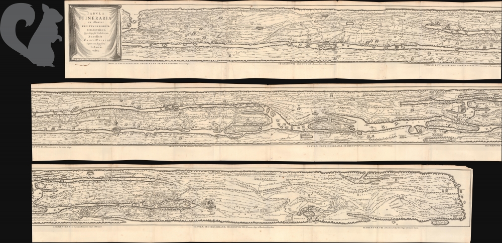
Tabula Itineraria ex illustri Peutingerorum Bibliotcheca Quae Augustae Vindelicorum Beneficio Marci Velseri Setpem-viri Augustani In lucem edita.
1652 (undated) 7.5 x 159.5 in (19.05 x 405.13 cm)
1652 (undated) 7.5 x 159.5 in (19.05 x 405.13 cm)
Description
This is Jan Jansson's c. 1662 map of the Peutinger Table or Peutinger Map, an ancient Roman road map of the known world. It is here presented in an unusual long format. Also known as the Castorius Stage Map or Theodosian Table, this is the only surviving representation of the Roman Empire's vast road network, offering a unique glimpse into how space, travel, and imperial infrastructure were conceptualized in antiquity.
An Ancient Roman Map
The Peutinger Table, or Tabula Peutingeriana, is a unique medieval copy of an ancient Roman road map that visually represents the network of imperial roads (viae) stretching across the Roman Empire, from the British Isles and Spain in the west to India in the east. Thought to be based on a 4th or 5th-century Roman original, the surviving version was produced in the 13th century and named after Konrad Peutinger, a Renaissance humanist. Unlike modern geographic maps, the Peutinger Table is highly schematic, laid out as a long, narrow scroll designed for itinerarium-style reference rather than accurate scale or spatial orientation. It features cities, waystations, rivers, and notable landmarks like Rome and Constantinople, as well as mythical and symbolic elements. Though distorted in shape, it offers invaluable insight into Roman imperial infrastructure, administrative geography, and how travel and communication were conceived in antiquity. Today, the original Peutinger manuscript is preserved in the Austrian National Library in Vienna.From Agrippa to Ortelius to Jansson
The Peutinger Table is a descendant of a Roman map originally commissioned by Marcus Vipsanius Agrippa (63 BCE - 12 BCE), later cut into marble and displayed in Rome. There is some debate about its dates, but the inclusion of Pompeii, destroyed in 79 CE, supports the Julio-Claudian Period (27 BCE - 68 CE). Later additions like Constantinople and Ravenna suggest a revision in the 4th or 5th century. The surviving version, a 13th-century manuscript missing its westernmost portion, was rediscovered in 1494 by the Humanist Conrad Celtes (1459 - 1508), supposedly in a library in Worms, and passed to Konrad Peutinger (1465 - 1547), for whom it is named. Even in his own time, it was widely believed that Celtes stole the map on behalf of Holy Roman Emperor Maximilian I (1495 - 1519). In 1591, Marcus Welser (Marci Velseri; 1558 - 1614), a relative of Peutinger, published the first printed edition in Venice. Abraham Ortelius, from whom the Peutinger Map was a subject of deep fascination, was dissatisfied with Welser's edition and produced his own from manuscript copies. Ortelius's edition was published posthumously in 1598 by Moretus and later included in Bertius's Theatrum Geographiae Veteris (1619) and in the Parergon (1624). In 1652, Jan Jansson issued his own version of Ortelius's Peutinger map in his Accuratissima Orbis Antiqui Delineatio, a historical atlas modeled on the Parergon.Publication History and Census
Like the Ortelius model, the Jansson edition of the Itineraria Peutingeria was divided into 4 sheets, each featuring 2 sections, for a total of 8. The Jansson edition appeared in several of his atlases, but also separately, as here. This is not simply the atlas-edition dissected and joined long-wise. Instead, it is a separate printing from the original plates )obvious from the large lower margins), which suggests that part of the 2-map plates were masked out for each strike. We note at least 3 examples the map thus, either folded or in scroll format, having entered the market in the last 20 years, all adhering to the 1652 date.Cartographer
Jan Jansson or Johannes Janssonius (1588 - 1664) was born in Arnhem, Holland. He was the son of a printer and bookseller and in 1612 married into the cartographically prominent Hondius family. Following his marriage he moved to Amsterdam where he worked as a book publisher. It was not until 1616 that Jansson produced his first maps, most of which were heavily influenced by Blaeu. In the mid 1630s Jansson partnered with his brother-in-law, Henricus Hondius, to produce his important work, the eleven volume Atlas Major. About this time, Jansson's name also begins to appear on Hondius reissues of notable Mercator/Hondius atlases. Jansson's last major work was his issue of the 1646 full edition of Jansson's English Country Maps. Following Jansson's death in 1664 the company was taken over by Jansson's brother-in-law Johannes Waesberger. Waesberger adopted the name of Jansonius and published a new Atlas Contractus in two volumes with Jansson's other son-in-law Elizée Weyerstraet with the imprint 'Joannis Janssonii haeredes' in 1666. These maps also refer to the firm of Janssonius-Waesbergius. The name of Moses Pitt, an English map publisher, was added to the Janssonius-Waesbergius imprint for maps printed in England for use in Pitt's English Atlas. More by this mapmaker...
Condition
Very good. Some edge wear and wear along old fold lines. Slight splitting at a few folds not affected printed map.
References
Shirley, Rodney W., The Mapping of the World: Early Printed World Maps 1472-1700, #393. Van der Krogt, P. C. J., Koeman's Atlantes Neerlandici, (3 Vols), #940/1:1-4:1.