This item has been sold, but you can get on the Waitlist to be notified if another example becomes available, or purchase a digital scan.
1707 Homann and Doppelmayr Map of the Moon
TabulaSelenographicaMoon-doppelmayr-1707$1,375.00

Title
Tabula Selenographica in qua Lunarium Macularum exacta Descriptio secundum Nomenclaturam Praestantissimorum Astronomorum tam Hevelii quam Riccioli Curiosis Rei Sidereae Cultoribus exhibetur Joh. Babr. Doppelmajero Math. P.P. upera Joh. Baptistae Homanni Norinbergae.
1707 or 1742 (undated) 20 x 23 in (50.8 x 58.42 cm)
1707 or 1742 (undated) 20 x 23 in (50.8 x 58.42 cm)
Description
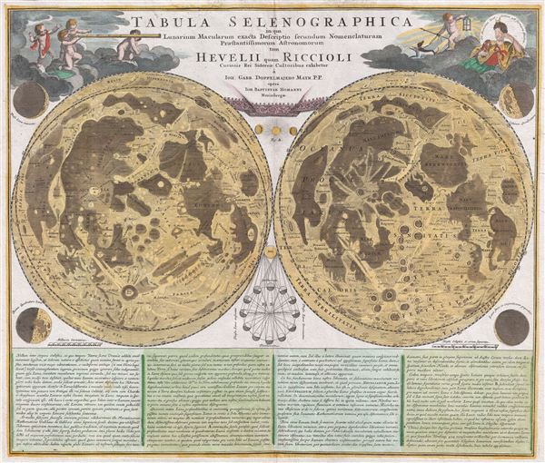
A stunning full color example of J. B. Homann and Johann Gabriel Doppelmayr's important c. 1742 map of the Moon. Essentially a comparative chart, Doppelmayer constructed this map to illustrate the lunar mapping of Johannes Hevelius (left) and Giovanni Battista Riccioli (right).
The left hand lunar map, composed by Hevelius, is a considered a foundational map in the science of selenography – or lunar cartography. This map first appeared in Hevelius' 1647 work Selenographia which laid the groundwork for most subsequent lunar cartographic studies. Here the moon is presented as it can never be seen from Earth, at a greater than 360 degrees and with all visible features given equal weight. In this map Hevelius also establishes the convention of mapping the lunar surface as if illuminated from a single source – in this case morning light. The naming conventions he set forth, which associate lunar features with terrestrial locations such as 'Asia Minor,' 'Persia,' 'Sicilia,' and etcetera were popular until the middle of the 18th century when Riccioli's nomenclature took precedence.
The Riccioli map, on the right, is more properly known as the Riccioli-Grimaldi map, for the fellow Jesuit Francesco Grimaldi with whom Riccioli composed the chart. This map first appeared in Riccioli and Grimaldi's 1651 Almagestum Novum. This was a significant lunar chart and offered an entirely new nomenclature which, for the most part, is still in use today. Curiously, though Riccioli, as a devout Jesuit, composed several treatises denouncing Copernican theory, he chose to name one of the Moon's most notable features after the astronomer – perhaps suggesting that he was a secret Copernicus sympathizer? Other well-known lunar features named by Riccioli include the Sea of Tranquility where Apollo 11 landed and where Neil Armstrong became the first human to set foot on the moon's surface.
The upper left and right hand quadrants feature decorative allegorical cartouche work that include images of angelic children looking through a telescope and a representation of the ancient Greek Moon goddess Selene. Additional mini-maps show the moon in various phases of its monthly cycle. Below the map proper extensive Latin text discusses Selenography.
This map first appeared in J. B. Homann's 1707 Neuer Atlas and was later reissued as plate no. 11 in Doppelmayr's important 1742 Atlas Coelestis, which was also published by the Nuremburg firm of Johann Baptist Homann. There is no discernible difference between the two issues and it is all but impossible to know in which of the two publications this map was drawn from.
CartographerS
Johann Gabriel Doppelmayr (September 27, 1677 - December 1, 1750) was a German mathematician and astronomer active in the first half of the 18th century. Doppelmayr was born in Nuremberg to a merchant family. He attended the Aegidien-Gymnasium and the University of Altdorf where he studied mathematics, physics, and law. His graduating dissertation, a study of the Sun, suggests an early interest in Astronomy. Following his studies in Altdorf, Doppelmayr traveled extensively in Europe and is known to have spent time at the University of Halle, as well as in Utrecht, Leiden, Oxford, and London. He returned to Nuremburg in 1704 to take up a mathematics professorship at his alma mater, the Aegidien-Gymnasium. It may have been here that he developed a relationship with the prominent Nuremburg map publisher J. B. Homann, with whom he prepared a number of important astronomical maps and atlases. The collaboration of over 20 years eventually led to the publication of the Atlas Novus Coelestis in 1742. This astounding work was the most elaborate and detailed astronomical atlas yet published and is today much admired for its rich beautifully engraved plates. Doppelmayr died on 1 December 1750 in Nuremberg, and many later sources claim that his death was caused by the fatal effects of a powerful electrical shock which he had received shortly before while experimenting with a battery of electric capacitors. Other sources, however, suggest that Doppelmayr's electrical experiments were performed several years earlier and were not the cause of his death. Today the Lunar crater Doppelmayr and a minor planetoid are named in his honor. More by this mapmaker...
Johannes Hevelius (January 28, 1611 - January 28, 1687) was a Polish politician, brewer, and astronomer. Hevelius was born into a prominent Danzig brewing family of Bohemian origins. Supported by Jopenbier fortunes Hevelius received an excellent education at the hands astronomer and polymath Peter Cruger. Following his primary education Hevelius moved to Leiden where he studied law and befriended such luminaries as Pierre Gassendi, Marin Marsenne, and Athanasius Kircher. On his return to Danzig he married his neighbor Katharine Rebeschke. Hevelius had a lifelong interest in politics, which, along with his family name, eventually earned him a number of important positions including councilor and mayor of Danzig. Nonetheless, his most significant achievements were in astronomy. Hevelius is considered 'the founder of lunar topography. His important book, Selenographia, sive Lunae descriptio laid the foundations for lunar cartography that are still in general use today. Hevelius established the conventions of naming lunar landforms after terrestrial features such as seas and political regions. He also formalized the idea of presenting the moon from a singular temporal perspective - in his case, the morning, though modern lunar maps tend to use evening light. In addition to his lunar work, Hevelius named a number of constellations that are still recognized today - including the sextant. Though known to have owned the world's largest tubular telescope, a monster of some 45 meters, Hevelius did most of his astronomical observations with a sextant and, as such, is considered one of the last astronomers to work without a telescope. His second wife, Elisabeth Koopmann, assisted in much of Hevelius' research and published two of Hevelius' astronomical texts after Hevelius' 1687 death. She is considered the world's first female astronomer. Learn More...
Giovanni Battista Riccioli (April 17, 1598 - June 25, 1671) was a Jesuit priest and astronomer active in Italy and Bologna during the early 17th century. Riccioli is most famous as the first person to accurately measure the rate of acceleration of a free falling body. However, his most substantial work is the Lunar measurement and mapping that he completed with Francesco Maria Grimaldi. Riccioli and Grimaldi's map of the moon established many of the planetary and lunar mapping conventions that are still in effect today including the nomenclature for most lunar topography. As a Jesuit and in much of his work, most specifically the 1651 Almagestum Novum which was written to that purpose, Riccioli expresses a clear rejection of Copernicus's heliocentric theories. Which makes it all the more curious that he chose to name one of the Moon's most prominent craters after the great Astronomer. Perhaps a tacit sympathy for Copernican theory? Riccioli died in Bologna in 1671. Learn More...
Source
Homann, J. B., Neuer Atlas bestehend in auserlesenen und allerneusten Land-Charten ueber die gantze Welt, und zwar erstlich nach Astronomischer Betrachtung der Bewegung des Himmels in dem Systemate Copernico-Hugeniano, dann auch nach der nturlichen Beschaffenheit und geographischen Eintheilung der mit Wasser umgebenen allgemeinen Erd-Kugeln in ihre besondere Monarchien, Koenigreiche, Staaten und Laender, (Nuremberg), 1707. Also in: Doppelmayr, J. G., Atlas Coelestis in quo Mundus Spectabilis et in eodem Stellarum omnium Phoenomena notabilia, circa ipsarum Lumen, Figuram, Faciem, Motum, Eclipses, Occultationes, Transitus, Magnitudines, Distantias, aliaque secundum Nic. Copernici et ex parte Tychonis de Brahe Hipothesin. Nostri intuitu, specialiter, respectu vero ad apparentias planetarum indagatu possibiles e planetis primariis, et e luna habito, generaliter e celeberrimorum astronomorum observationibus graphice descripta exhibentur, cum tabulis majoribus, (Homann, Nurenburg) 1742.
Condition
Very good. Original centerfold. Platemark visible. Blank on verso.
References
Warner, D. J., 'The Geography of Heaven and Earth', Rittenhouse: Journal of the American Scientific Instrument Enterprise, 1988, p. 64-66. Whitfiled, P., The Mapping of the Heavens, p. 93, 96-97.