
1932 Showa 7 Murasaki City Plan or Map of Taipei, Taiwan

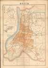

Full State Administration Map of Taipei. / Taipei City Street Map. / 臺北州管内全圖 / 臺北市街圖
Modernization of Taipai as jewel of a colonial empire.
- Digital Map Information
- Suitable for large format printing
- File Size: 28.77 MB
- File Type: ZIP / TIFF
- ICC color profile embedded
- Delivered instantly via download link
Modernization of Taipai as jewel of a colonial empire.
This is an elegant Showa 7 or 1932 map of Taipei, Taiwan, issued by Murasaki Chōei (村崎長昶) for sale in his Xin Gaotang Bookstore (新高堂書店). The map captures Taipei’s breakneck modernization as the political and administrative center of Japanese-dominated colonial Taiwan.A Closer Look
The map covers all of Colonial Era Taipei, but is centered on the old walled city - despite the fact that here the walls have been replaced with major roads, trams, and rail lines. The map offers expanded coverage over earlier maps, encapsulating the full urban development of Taipei at the time, with new development areas to the north, east, and south. It is further is coded to illustrate developed areas (shaded orange), railroad lines, roads, and trams. An inset map in the upper left covers all of Taipei County / Taihoku Prefecture. Numbers fill the map. While most are unique, some are repetitive, and increase to about 900. It is unclear what these represent, but they may be coded to a key that has today been lost.A Colonial Darling
Around 1932, Taipei was the political and administrative heart of Japan’s Taiwan colony, a showcase for imperial modernization and a laboratory for assimilationist policy. The city’s urban fabric reflected this duality: broad boulevards, concrete commercial blocks, and monumental civic buildings framed by Shinto shrines and police stations, while traditional Taiwanese neighborhoods persisted in markets and temple districts. Japanese investment brought electrified streetcars, rail connections, port improvements at nearby Keelung, and expanded public health and education systems intended both to pacify and to transform the local population. Economic development surged on the back of sugar, rice, and camphor industries, tying Taiwan into Japan’s industrial sphere and wartime provisioning. At the same time, cultural and political tensions simmered - Taiwanese elites sought space within the colonial bureaucracy and pressed for greater representation, even as the state tightened control through surveillance and censorship. The result was a city simultaneously modern, orderly, and outwardly cosmopolitan, yet unmistakably colonial, its progress inseparable from the hierarchies and ambitions of the Japanese empire.Publication History and Census
This map was published by Murasaki Chōei (村崎長昶) for sale in his Xin Gaotang Bookstore (新高堂書店). It was printed on May 20, 1932, and released on May 25 of the same year. We have identified an example at the Library of Congress, the University of Chicago, and the University of Wisconsin. We assume there are others in Japanese and Taiwanese collections, but we have been unable to trace them. No market history.Cartographer
Murasaki Chōei (村崎長昶; 1870 - 1960) was a Japanese book publisher active in Taipei, Taiwan. Murasaki is considered the founder of the Taiwan bookselling industry and was the largest bookseller in Taiwan during the Japanese Occupation (1895 - 1945). He studied at a private school in Japan before relocating to Okinawa in July of 1893. After the Japanese annexation of Taiwan following the First Sino-Japanese War (1894 - 1895), he was sent to Taipei with the Ministry of the Army. He initially handled engineering regulation and real estate sales for the Ministry. Later in 1895, he resigned to set up his own business, Muasaki Office, negotiating legal contracts and real estate sales. This business was apparently not very successful and Murasaki fell into heavy drinking. Despite this, in 1898, he founded another business, the Xin Gaotang Bookstore (新高堂書店). Initially a small stationer, the business grew rapidly. In 1915, he constructed a large three-story bookstore in Taipei's Changjing Village, at the modern intersection of Hengyang Road and Chongqing South Road. Other publishers and booksellers followed, transforming the area into an industry hub. By the time World War II broke out, Xin Goatang was the largest bookseller in Taiwan. After the war, Murasaki returned to Japan, where he died shortly thereafter. His bookstore, under new management, was renamed the Oriental Publishing House. The original brick building survived until the 1980s, when it was demolished and replaced with a modern mall known as the 'Oriental Building.' Further Details...
Condition
Very good. Some wear and toning on old fold lines. Reinforced archivally on verso were necessary.
References
Library of Congress, G7914.T5 1932. OCLC 861356230.