This item has been sold, but you can get on the Waitlist to be notified if another example becomes available, or purchase a digital scan.
1774 Cook Nautical Map of New Zealand Harbors
TamiseTolaga-cook-1774$200.00

Title
Riviere Tamise de Baye Mercure a la Nle. Zélande/ Baye des Isles dans la Nle. Zélande. / Baye de Tolaga dans la Nle. Zélande.
1774 (undated) 11.5 x 13 in (29.21 x 33.02 cm) 1 : 2400000
1774 (undated) 11.5 x 13 in (29.21 x 33.02 cm) 1 : 2400000
Description
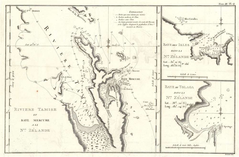
This is the 1774 first French edition of the first map of New Zealand's North Island, navigated by then-Lieutenant James Cook during his first voyage of discovery aboard the H.M.S. Endeavor. Rock with a hole pierced thro' it like the Arch of a Bridge... and this was one reason why I gave the Cape the above name, because Piercy seem'd very proper for that of the Island. Despite his sense of humor, the navy would continue to give Cook command of ships.
Coromandel Peninsula
The main chart shows Cook's track up the east coast of North Island to the Endeavour's November 9, 1769 anchorage at Mercury Bay. Topography is shown pictorially; anchorages both in Mercury Bay and around the peninsula in the Firth of Thames are marked. Navigational threats, such as underwater rocks, are shown; coastlines that are presumed to exist (but that Cook did not explore) are sketched in with faint hachure.Bay of Isles
The second chart on the sheet focuses on the Bay of Isles, near the northern extent of the Coromandel Peninsula. Point Pocock (now Wiwiki) is named, as are Piercy Island and Cape Brett. The latter were named as the result of a visual pun, inflicted by Cook at the expense of Senior Naval Lord Sir Piercy Brett. Cook chose the name because the island featured aTolaga Bay
The third chart is of Tolaga Bay, Cook's October 24 anchorage, and site of one of the expedition's important longitudinal calculations. (These were vital for confirming the positions of the various coastal formations plotted at sea.)Publication History and Census
This map was engraved by Robert Bénard for the 1774 French edition of James Hawkesworth's 1773 account of Cook's voyages. It follows the 1772-1773 English edition engraved by William Whitchurch and published in 1773. While Hawkesworth's book is well represented in institutional collections, this separate map appears catalogued only in the National Library of Australia.CartographerS
Captain James Cook (7 November 1728 - 14 February 1779) is a seminal figure in the history of cartography for which we can offer only a cursory treatment here. Cook began sailing as a teenager in the British Merchant Navy before joining the Royal Navy in 1755. He was posted in America for a time where he worked Samuel Holland, William Bligh, and others in the mapping of the St. Lawrence River and Newfoundland. In 1766 Cook was commissioned to explore the Pacific and given a Captaincy with command of the Endeavour. What followed were three historic voyages of discovery, the highlights of which include the first European contact with eastern Australia, the discovery of the Hawaiian Islands (among many other Polynesian groups), the first circumnavigation of New Zealand, some of the first sightings of Antarctica, the first accurate mapping of the Pacific Northwest, and ultimately his own untimely death at the hands of angry Hawaiians in 1779. The influence of Cook work on the mapping and exploration of the Pacific cannot be understated. More by this mapmaker...
John Hawkesworth (c. 1715 - November 16, 1773) was an English born writer and editor born London. Hawkesworth, who is said to have been self educated, succeeded Samuel Johnson as the parliamentary debate compiler for "Gentleman's Magazine". He was a deeply religious and moral map who brilliant defense of morality earned him an LL. D degree from the Archbishop of Canterbury. Hawkesworth went on to publish a series of scholarly books and essays including a 12 volume edition of Jonathan Swift's work. In 1772 Hawkesworth was commissioned by the Admiralty to compile and edit James Cook's journals. The resultant work An Account of the Voyages undertaken ... for making discoveries in the Southern Hemisphere was one of the first ethnographic account of the South Seas and was widely published in England and abroad. Though highly influential, Hawkesworth's work received heavy criticism from scholars who claim that he liberally altered much of the text in the name of morality. Learn More...
Robert Bénard (1734 - c. 1785) was a French engraver. Born in Paris, Bénard is best known for supplying a significant number of plates (at least 1,800) for the Encyclopédie published by Diderot and Alembert. He also is remembered for his work with the Académie des Sciences, most notably the Descriptions des Arts et Métiers Learn More...
Source
Hawkesworth, J., Relation des voyages entrepris par ordre de Sa Majeste britannique, actuellement regnante; pour faire des decouvertes dans l'hemisphere meridional ..., (Paris: Chez Saillant et Nyon ... Chez Panckoucke, Hotel de Thou) 1774.
Condition
Very good condition. Two mended wormholes at centerfold not affecting printed image, some faint offsetting, else excellent condition with full margins.
References
OCLC 535498480.