1780 Bonne Map of Tartary or Central Asia: Iraq, Afghanistan, Iran, Tibet
Tartary-bonne-1780-2$175.00

Title
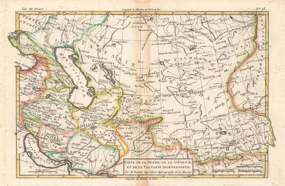
Carte de la Perse, de la Georgie, et de la Tartarie Independante.
1780 (undated) 8 x 12.25 in (20.32 x 31.115 cm) 1 : 15900000
1780 (undated) 8 x 12.25 in (20.32 x 31.115 cm) 1 : 15900000
Description
This map of Tartary, or Central Asia, from the Black Sea to Tibet was issued in 1780 by Rigobert Bonne. It covers much of the Middle East and Central Asia, including 'Independent Tartary,' which was gradually incorporated into the Russian Empire in the 19th century.
A Closer Look
This map is small but detailed and beautifully crafted. Towns, religious structures, cities, and mountains are depicted in miniature representations. An impressive, if somewhat imprecise, level of detail greets the viewer. As is reflected here, the territories historically considered as Persia were disunified at this time. The long-reigning Safavid Dynasty was in decline and under attack from multiple directions, including at the hands of the Ottomans, Russians, and Afghans. In the mid-1730s, the brilliant military commander Nader Shah established a new Afsharid Dynasty, expelled the invading forces, and even staged a raid on Mughal Delhi that brought back tremendous riches to Persia. However, in his later years, Nader became cruel and megalomaniacal, inciting revolts and eventually his own assassination in 1747. Afterwards, Persia descended into a chaotic situation with further foreign invasions, until relative calm was restored by Karim Khan of the Zand Dynasty based at Shiraz (here as Shiras).Publication History and Census
This map was drawn by Bonne for Guillame Raynal's Atlas de Toutes les Parties Connues du Globe Terrestre, Dressé pour l'Histoire Philosophique et Politique des Établissemens et du Commerce des Européens dans les Deux Indes. Both the map itself and the entire atlas in this edition are held by a handful of libraries in North America and Europe.CartographerS
Rigobert Bonne (October 6, 1727 - September 2, 1794) was one of the most important French cartographers of the late 18th century. Bonne was born in Ardennes à Raucourt, France. He taught himself mathematics and by eighteen was a working engineer. During the War of the Austrian Succession (1740 - 1748) he served as a military engineer at Berg-op-Zoom. It the subsequent years Bonne became one of the most respected masters of mathematics, physics, and geography in Paris. In 1773, Bonne succeeded Jacques-Nicolas Bellin as Royal Cartographer to France in the office of the Hydrographer at the Depôt de la Marine. Working in his official capacity, Bonne compiled some of the most detailed and accurate maps of the period - most on an equal-area projection known erroneously as the 'Bonne Projection.' Bonne's work represents an important step in the evolution of the cartographic ideology away from the decorative work of the 17th and early 18th century towards a more scientific and practical aesthetic. While mostly focusing on coastal regions, the work of Bonne is highly regarded for its detail, historical importance, and overall aesthetic appeal. Bonne died of edema in 1794, but his son Charles-Marie Rigobert Bonne continued to publish his work well after his death. More by this mapmaker...
Guillaume Thomas Raynal (April 12, 1711 - March 6, 1796) was a French writer, philosopher, and historian active during the Enlightenment. Raynal was educated as a Jesuit, but left the order for unknown reasons, and moved to Paris where he dedicated himself to the production of a number of minor but popular historical works. Raynal's histories opened doors to elite social and artistic circles where he met and befriended various members of the Philosophe Coteries. Raynal's most important work is generally considered to be a 1770 collaboration with Diderot and others entitled, L'Histoire philosophique et politique des établissements et du commerce des Européens dans les deux Indes. Some of the philosophical ideas developed in the book drew negative attention from the authorities who banned the book and posted a notice for the arrest of its authors. Raynal fled to Berlin and later to St. Petersburg, where he lived for a number of years before returning to France in 1787. Though not a cartographer Raynal's name is often attached to several Atlases by Rigobert Bonne, from whom he composed the text. Learn More...
Source
Raynal, G., Atlas de Toutes les Parties Connues du Globe Terrestre, Dressé pour l'Histoire Philosophique et Politique des Établissemens et du Commerce des Européens dans les Deux Indes, (Paris) 1780.
Condition
Good. Some discoloration along fold line and foxing in the margins.
References
Rumsey 3083.034, OCLC 70125567, 837639509.