
This item below is out of stock, but another example (left) is available. To view the available item, click "Details."
Details
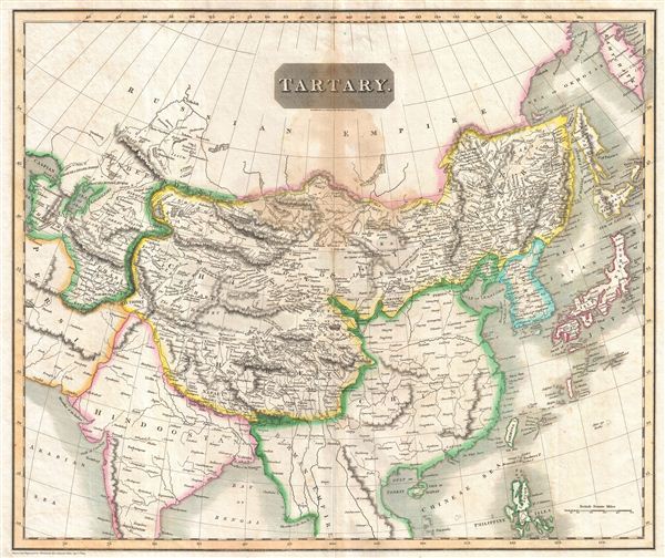
1814 Thomson Map of Tartary (Central and East Asia)
1814 (dated) $300.00
1814 Thomson Map of Tartary (i.e. Mongol Empire of Central and East Asia)
Tartary-thomson-1814$75.00

Title
Tartary.
1814 (dated) 19.75 x 23.5 in (50.165 x 59.69 cm)
1814 (dated) 19.75 x 23.5 in (50.165 x 59.69 cm)
Description
This fascinating hand colored 1814 map of central and east Asia, covering southern Tartary, Tibet (Thibet), Mongolia, and generally the whole of Central Asia. The area is named after the 'Tartars,' the Turkic and Mongol peoples of the Mongol Empire. The region covered extends from the Caspian Sea to Japan and Korea.
Politically this map is configured roughly along the lines of the old Mongol Empire, with the territories controlled by the sons of Kublai Khan, based in Peking, defined as Chinese Tartary, and the territory to the west of Kashgar, modern day Kazakhstan, Uzbekistan, and Turkmenistan, occupied by various independent 'Hordes,' including the Great Horde, the Kirguses Hordes, and the Kharizm. The supposed site of the ancient capital of the Great Khan, Karakum, is noted in the Gobi. A portion of the ancient Silk Route caravan from Lok Nor to China is noted along with various caravan stops along the way. The cities of Bokhara, Kashgar, and Samarkand are also noted. The sea between Japan and Korea, whose historic name is currently a matter of dispute between the two countries, is identified as the Sea of Japan. Magnificent size, beautiful color, and high detail make this one of the finest maps of these central Asian nations to appear in the early 19th century. The whole is beautifully engraved in the minimalist English style pioneered in the early part of the 19th century. Relief is shown by hachure with towns, cities, and major topographical features identified.
This map is a steel plate engraving and was issues as plate no. 31 in Edinburgh cartographer John Thomson's 1817 New General Atlas.
Cartographer
John Thomson (1777 - c. 1841) was a Scottish cartographer, publisher, and bookbinder active in Edinburgh during the early part of the 19th century. Thomson apprenticed under Edinburgh bookbinder Robert Alison. After his apprenticeship, he briefly went into business with Abraham Thomson. Later, the two parted ways, John Thomson segueing into maps and Abraham Thomson taking over the bookbinding portion of the business. Thomson is generally one of the leading publishers in the Edinburgh school of cartography, which flourished from roughly 1800 to 1830. Thomson and his contemporaries (Pinkerton and Cary) redefined European cartography by abandoning typical 18th-century decorative elements such as elaborate title cartouches and fantastic beasts in favor of detail and accuracy. Thomson's principle works include Thomson's New General Atlas, published from 1814 to 1821, the New Classical and Historical Atlas of 1829, and his 1830 Atlas of Scotland. The Atlas of Scotland, a work of groundbreaking detail and dedication, would eventually bankrupt the Thomson firm in 1830, at which time their plates were sequestered by the court. The firm partially recovered in the subsequent year, allowing Thomson to reclaim his printing plates in 1831, but filed again for bankruptcy in 1835, at which time most of his printing plates were sold to A. K. Johnston and Company. There is some suggestion that he continued to work as a bookbinder until 1841. Today, Thomson maps are becoming increasingly rare as they are highly admired for their impressive size, vivid hand coloration, and superb detail. More by this mapmaker...
Source
Thomson, J. A New General Atlas, (Edinburgh) 1814.
Condition
Good condition. Original centerfold exhibits some light toning . Large damstain top center - see image.
References
Rumsey 1007.040. Phillips (Atlases) 731. Newberry Library: Ayer 135 T4 1817.