1814 Thomson Map of Tartary (Central and East Asia)
Tartary-thomson-1814-2$300.00

Title
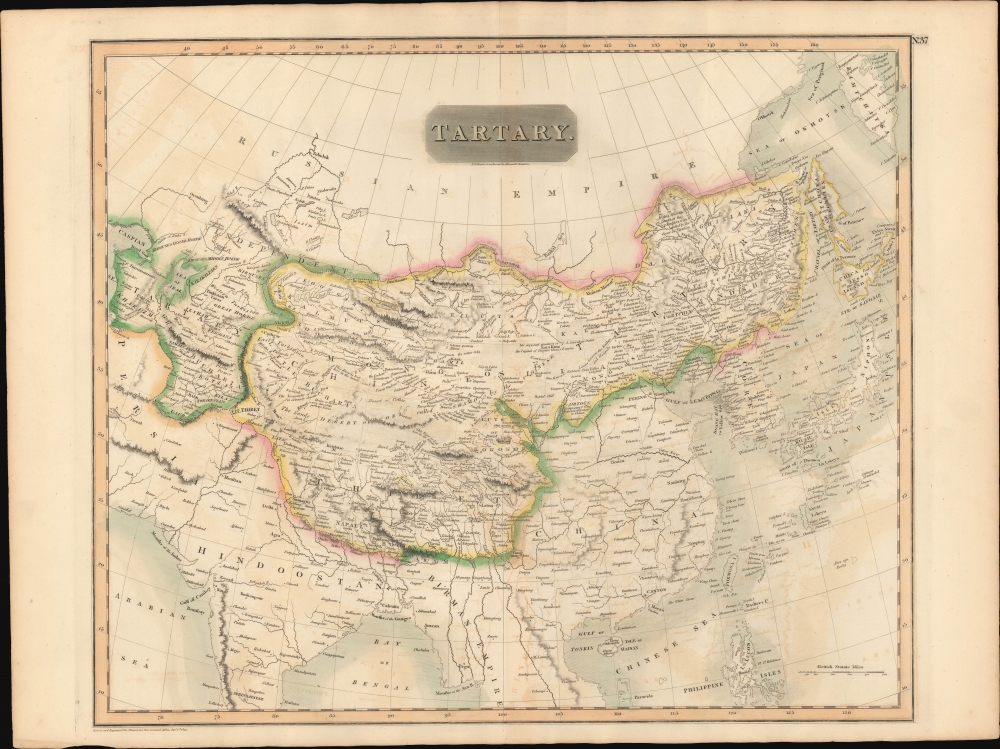
Tartary.
1814 (dated) 19.75 x 23.5 in (50.165 x 59.69 cm) 1 : 13000000
1814 (dated) 19.75 x 23.5 in (50.165 x 59.69 cm) 1 : 13000000
Description
A beautiful large format 1814 John Thomson map of Tartary - a nebulous term that referred to all of Central Asia north of China and India, and South of the Russian Empire, and from the Caspian Sea, to Sakhalin.
A Closer Look
Coverage is expansive, illustrating a broad but then poorly understood swath of Asia. It is divided into Independent Tartary, corresponding loosely to modern day Turkmenistan and Uzbekistan, and Chinese Tartary, embracing lands claimed by the Qing, including Tibet, the Gobi, and most of Mongolia. In essence, the map is configured roughly along the lines of the old Mongol Empire, with the territories controlled by the sons of Kublai Khan, based in Peking, defined as Chinese Tartary, and the territory to the west of Kashgar, modern day Kazakhstan, Uzbekistan, and Turkmenistan, occupied by various independent 'Hordes,' including the Great Horde, the Kirguses Hordes, and the Kharizm. The supposed site of the ancient capital of the Great Khan, Karakum, is noted in the Gobi. A portion of the ancient Silk Road caravan route from Lok Nor to China is recognizable with caravan stops marked, among them the legendary cities of Bokhara, Kashgar, and Samarkand. Within a few years, Russia and England would begin maneuvering to seize control of this area in a decades long conflict known as the 'Great Game'.Publication History and Census
This map was prepared and engraved in 1814 in Edinburgh for inclusion in the 1817 first edition of John Thomson's New General Atlas. Unlike most Thomson maps, no engraver is named. The map is well represented in institutions and appears on the market from time to time.Cartographer
John Thomson (1777 - c. 1841) was a Scottish cartographer, publisher, and bookbinder active in Edinburgh during the early part of the 19th century. Thomson apprenticed under Edinburgh bookbinder Robert Alison. After his apprenticeship, he briefly went into business with Abraham Thomson. Later, the two parted ways, John Thomson segueing into maps and Abraham Thomson taking over the bookbinding portion of the business. Thomson is generally one of the leading publishers in the Edinburgh school of cartography, which flourished from roughly 1800 to 1830. Thomson and his contemporaries (Pinkerton and Cary) redefined European cartography by abandoning typical 18th-century decorative elements such as elaborate title cartouches and fantastic beasts in favor of detail and accuracy. Thomson's principle works include Thomson's New General Atlas, published from 1814 to 1821, the New Classical and Historical Atlas of 1829, and his 1830 Atlas of Scotland. The Atlas of Scotland, a work of groundbreaking detail and dedication, would eventually bankrupt the Thomson firm in 1830, at which time their plates were sequestered by the court. The firm partially recovered in the subsequent year, allowing Thomson to reclaim his printing plates in 1831, but filed again for bankruptcy in 1835, at which time most of his printing plates were sold to A. K. Johnston and Company. There is some suggestion that he continued to work as a bookbinder until 1841. Today, Thomson maps are becoming increasingly rare as they are highly admired for their impressive size, vivid hand coloration, and superb detail. More by this mapmaker...
Source
Thomson, J., A New General Atlas, (Edinburgh: Baldwin, Cradock, Joy) 1817.
Thomson's New General Atlas was first published in 1817 and continued to be published until about 1821. This is the first of Thomson's major cartographic works and the atlas for which is most celebrated. The New General Atlas follows in the Edinburgh School, which eschews excessive decoration in favor of a more minimalistic fact-based cartographic vision, as established by John Pinkerton, Laurie and Whittle, John Cary, and others in the previous decades. The maps are notable for their massive scale, heavy stock, elegant color work, and easy-to-read typefaces. Although the atlas stopped being published after 1821, Thomson continued to offer 'supplementary' maps that could be tipped into the atlas as late as 1830, when he declared bankruptcy. The maps in the Thomson Atlas were engraved by Thomas Clerk, William Dassauville, Nathaniel Rogers Hewitt, James Kirkwood, Robert Kirkwood, John Menzies, George Menzies, Edward Mitchell, John Moffatt, Samuel John Neele, Robert Scott, and James Wyld.
Condition
Very good. Original centerfold.
References
Rumsey 1007.040. Phillips (Atlases) 731. Newberry Library: Ayer 135 T4 1817.