1831 Dower / Teesdale Map of Tasmania
Tasmania-dower-1831$550.00

Title
Van-Diemans Land.
1831 (dated) 15.25 x 12.5 in (38.735 x 31.75 cm) 1 : 1100000
1831 (dated) 15.25 x 12.5 in (38.735 x 31.75 cm) 1 : 1100000
Description
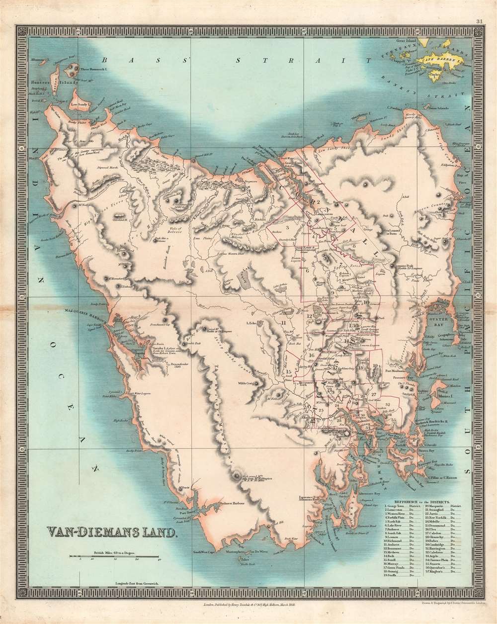
This is a brilliantly colored 1831 Henry Teesdale / John Dower map of Van Diemen's Land (Tasmania) published in their A New General Atlas of the World. It depicts the territory at a time when it primarily served as a British penal colony, gaining it a notorious reputation as an inhospitable and undesirable place.
As is evident here, knowledge of the interior, especially the western half, was limited. Many areas are described simply, such as 'emu plain,' ' peak like a volcano,' 'sandy,' and 'forest.' Two settlements of considerable size developed at Hobart Town (now Hobart) and Launceston, and penal labor was employed to build up public works, such as roads, government buildings, and prisons. In 1853, penal transportation to the island ceased, and soon afterward it adopted a constitution and changed its name to Tasmania.
A Closer Look
This map was made as British colonial presence on Tasmania and surrounding islands was increasing. Beginning from a small military outpost, established in 1803 to prevent the French claims, the island's population grew quickly, including free settlers and thousands of convicts bound for labor in the households of free settlers and in factories, penal stations, and prisons. Some of these prisons were especially desolate and brutal places, where violence was commonplace. If and when they were released, former convicts generally left the island as soon as possible, with most resettling in Victoria. In the meantime, the indigenous population of Tasmania had been drastically reduced by disease and warfare, from several thousand to around 300 by the time this map was published.As is evident here, knowledge of the interior, especially the western half, was limited. Many areas are described simply, such as 'emu plain,' ' peak like a volcano,' 'sandy,' and 'forest.' Two settlements of considerable size developed at Hobart Town (now Hobart) and Launceston, and penal labor was employed to build up public works, such as roads, government buildings, and prisons. In 1853, penal transportation to the island ceased, and soon afterward it adopted a constitution and changed its name to Tasmania.
Publication History and Census
This map was engraved by John Dower for the 1831 edition of A New General Atlas of the World, published by Henry Teesdale. This appears to be an especially rare presentation of this map, as most examples do not show such vivid and full color, only hand-colored outlines of territories (the example held by the National Library of Australia is an exception). The 1831 edition of this map is only independently cataloged in the holdings of six institutions, while the entire atlas is held by roughly a dozen institutions, though as stated above the present map is likely distinct from those examples in coloration.CartographerS
John James Dower (June 1, 1825 - 1901) was a well-respected mapmaker, print seller, and publisher based in London, England. Dower is the heir to the more prominent London engraver and mapmaker John Crane Dower (1791 - 1847). Dower worked with many prominent middle to late 19th century London map publishers including Weller, Cassell, Bacon, Petermann, and others. He was elected to the Royal Geographical Society in 1854. Dower also published on maps his own account including one atlas and various school geographies. In addition to his cartographic work, Dower is well known as an engraver of military scenes. More by this mapmaker...
Henry Teesdale (December 1776 - January 1856) was a British map publisher active in the first half of the 19th century. Teesdale was born in London. He was elected to the Royal Geographical Society in 1830. Teesdale initially partnered with John Hordan and William Colling Hobson as Henry Teesdale and Company, but this partnership was dissolved in 1832. Afterwards Teesdale continued to publish maps and atlases on his own account. He worked with several major British map engravers of the period including John Crane Dower, Christopher Greenwood, and Josiah Henshall, among others. His most prominent work is a large map of the world engraved by Dower. He must have enjoyed considerable commercial success because in 1845 he is registered as a partner in the Royal Bank of Scotland. Teesdale died in January of 1856 and was buried in All Souls, Kensal Green. Learn More...
Source
Dower, John, A New General Atlas of the World, (London: Teesdale) 1831.
Condition
Very good. Some toning and some wear along the central fold line.
References
OCLC 43218176, 221454834.