This item has been sold, but you can get on the Waitlist to be notified if another example becomes available, or purchase a digital scan.
1702 De Fer Map of Northern South America (Brazil, Peru, Columbia, Venezuela)
TerreFermePerou-defer-1702$175.00

Title
La Terre Ferme et le Perou avec le Pays des Amazones et le Bresil dans l'Amerique Meridionale.
1702 (dated) 9.5 x 13.5 in (24.13 x 34.29 cm) 1 : 23000000
1702 (dated) 9.5 x 13.5 in (24.13 x 34.29 cm) 1 : 23000000
Description
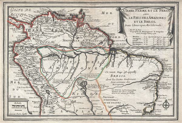
This is a scarce and beautiful example of Nicholas De Fer's 1702 map of northern South America. It covers from Panama to Rio de Janeiro and renders the entire region in extraordinary detail offering both topographical and political information with mountains beautifully rendered in profile.
This map, like most early maps of the area, contrasts a detailed mapping of the coast with a speculative discussion of the interior, particularly the Amazon Basin. It offers a fairly accurate mapping of both the east and west coasts with exceptional detail in the populated Andean regions of Columbia, Ecuador (Labeled Quito), and Peru. Lima, Quito, Valladolid (Valadolid), Arequipa, Trujillo (Truxilla) and other important trading centers of the region are noted. In Portuguese controlled Brazil, Rio de Janeiro, San Salvador and San Sebastian are noted. Lake Maracaibo, in modern day Venezuela, is slightly malformed and elongated.
The interior is where this map gets interesting. De Fer's mapping of South America's interior is full of inaccuracy, curiosities, and ample fodder for the gold hunting European. Our survey of this map begins with De Fer's fairly accurate mapping of the of the Amazon and Orinoco River systems - though he does erroneously connect the two, an understandable error common to maps of the period. He also drops the popular myth of Lake Parima and Eldorado in Guyana, but maintains the apocryphal Lake of Xarayes as the northern terminus of the Paraguay River.
The Xarayes, a corruption of 'Xaraies' meaning 'Masters of the River,' were an indigenous people occupying what are today parts of Brazil's Matte Grosso and the Pantanal. When Spanish and Portuguese explorers first navigated up the Paraguay River, as always in search of El Dorado, they encountered the vast Pantanal flood plain at the height of its annual inundation. Understandably misinterpreting the flood plain as a gigantic inland sea, they named it after the local inhabitants, the Xaraies. The Laguna de Xarayes almost immediately began to appear on early maps of the region and, at the same time, almost immediately took on a legendary aspect as the gateway to El Dorado. To the east and north of this lake, De Fer speculates connections to the Amazon and the St. Francois rivers. He includes two notes, one stating that 'It is believed that the Lake communicates with the Amazon' and the other reads 'The inhabitants of Brazil believe that the Lake discharges in the North Sea.'
Altogether this is a spectacular map of the region. This map was engraved by Charles Inselin and created by Nicholas De Fer for his 1701 Atlas.
CartographerS
Nicholas de Fer (1646 - October 25, 1720) was a French cartographer and publisher, the son of cartographer Antoine de Fer. He apprenticed with the Paris engraver Louis Spirinx, producing his first map, of the Canal du Midi, at 23. When his father died in June of 1673 he took over the family engraving business and established himself on Quai de L'Horloge, Paris, as an engraver, cartographer, and map publisher. De Fer was a prolific cartographer with over 600 maps and atlases to his credit. De Fer's work, though replete with geographical errors, earned a large following because of its considerable decorative appeal. In the late 17th century, De Fer's fame culminated in his appointment as Geographe de le Dauphin, a position that offered him unprecedented access to the most up to date cartographic information. This was a partner position to another simultaneously held by the more scientific geographer Guillaume De L'Isle, Premier Geograph de Roi. Despite very different cartographic approaches, De L'Isle and De Fer seem to have stepped carefully around one another and were rarely publicly at odds. Upon his death of old age in 1720, Nicolas was succeeded by two of his sons-in-law, who also happened to be brothers, Guillaume Danet (who had married his daughter Marguerite-Geneviève De Fer), and Jacques-François Bénard (Besnard) Danet (husband of Marie-Anne De Fer), and their heirs, who continued to publish under the De Fer imprint until about 1760. It is of note that part of the De Fer legacy also passed to the engraver Remi Rircher, who married De Fer's third daughter, but Richer had little interest in the business and sold his share to the Danet brothers in 1721. More by this mapmaker...
Charles Inselin (fl. c. 1700 - 1730) was a prominent French engraver active in Paris during the late 17th and early 18th centuries. Inselin engraved for prominent cartographers ranging from Nicholas Sanson to Eusebio Kino and Nicholas De Fer. He was also a minor publisher of maps and engravings on his own account. Little else is known of his life. Learn More...
Source
Fer, Nicholas de, Cartes et Descriptions Generales et Particulieres pour l'intelligence des affaires du temps, au sujet de la Succession de la Couronne d'Espagne, en Europe, en Asie, Afrique, et Amerique, (Paris) 1701.
Condition
Very good. Minor wear and toning along original centerfold. Original platemark visible.