This item has been sold, but you can get on the Waitlist to be notified if another example becomes available, or purchase a digital scan.
1771 Treskot Map of Russian Siberia and the Siberian Arctic
TerritoriiJakutensis-treskot-1771$600.00

Title
Territorii Jakutensis pars orientalis.
1771 (undated) 19 x 23.5 in (48.26 x 59.69 cm) 1 : 4000000
1771 (undated) 19 x 23.5 in (48.26 x 59.69 cm) 1 : 4000000
Description
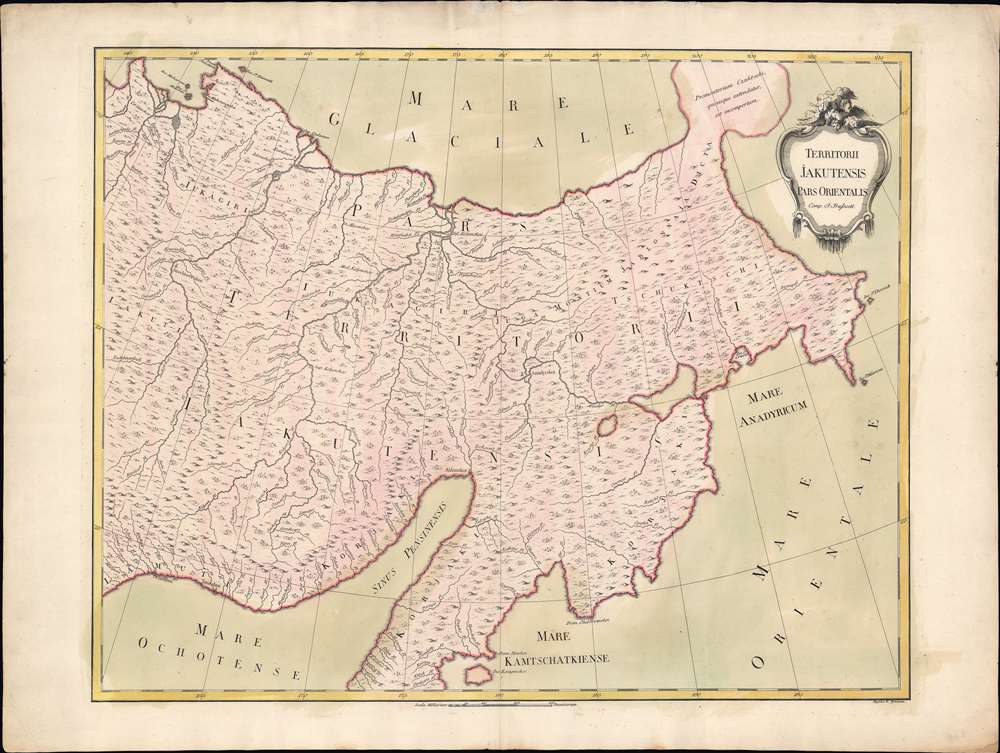
An exceptional separately issued 1771 Ivan Fomic Treskot map of Siberia, part of the Treskot-Schmidt effort to map Siberia between 1770 and 1776. This map represents one of the earliest specific published maps of northeastern Siberia. Coverage extends from the Kolyma River to the Bearing Strait and from the bulbous Tschtuki Peninsula to Penzhin Bay and Shielikhov Gulf (northern Sea of Okhotsk), and northern Kamchatka. The map is a composite of the finest cartographic knowledge then available to the Russian Academy at St. Petersburg. The treatment of the complex inland river systems in particular represents a major step forward in regional cartography.
Dezhnev ultimately proved that there was indeed a nautical route from Russia to East Asia, but at the same time confirmed that it was exceedingly impractical. On his one-year voyage, Dezhnev and his small fleet skirted the Siberian coast in rough conditions, recording only loosely what they saw, but nonetheless described several islands and two large peninsulas. His description of the promontory was subsequently embraced by other cartographers who, lacking serious scientific data from the Dezhnev expedition, surmised the form. Essentially, Witsen's peninsula is a mismapping of the existent Cape Shelagskiy, which Dezhnev rounded, located about 1,000 miles west of the Bering Strait.
The first non-Russian to study this data was Dutchman Nicholaas Witsen, who prepared a map in 1687 based upon Dezhnev's records that he discovered on a 1665 trip to Moscow – hence 'Witsen’s Peninsula' was introduced to western Europe. When European cartographers saw Witsen's map and began to copy it, they did not know of Dezhnev's voyage or Witsen's sources so, by mid-18th century, some speculated that this was not a peninsula, but a land bridge extending all the way to America. Others like Gerhard Friedrich Müller (1705 - 1783), who worked for the Russian Academy, gave Witsen's peninsula a more bulbous form - as here - to conform with other reports of Tschuktschi.
The Dezhnev Anomaly or Witsen's Peninsula
Our eyes are immediately drawn to the the bulbous peninsula extending northeasterly from Siberia in the vicinity of the Kolyma River and identified as 'Promontorium Czutschi'. Today this semi-mythical peninsula is known as Witsen's Peninsula or the Dezhnev Anomaly. Around 1648, the Cossack Semen Ivanovich Dezhnev (1605 - 1673) put together a rough and ready expedition to explore the waterways around northeastern Siberia. His company consisted of Fedot Alekseyev, traveling with the merchants Andreev and Afstaf'iev (representing the Guselnikov merchant house), who provided their own ship, and Gerasim Ankudinov, an experienced sea captain with his own ship and some 30 men. Dezhnev, along with Mikhail Stadukhin, recruited some 19 men of their own and procured a traditional kocha ship. Including escort vessels, a total seven ships sailed from the mouth the Kolyma River, along the Siberian Arctic, to the Anadyr River north of Kamchatka, and in doing so became the first Europeans to sail through the Bering Strait some 80 years before Vitus Bering. Dezhnev described rounding a large mountainous promontory identified as Chukchi, Tschuktschi, or Chukotka Peninsula. Of the seven vessels of the multiple leaders, only three ships, including Dezhnev’s, survived the passage.Dezhnev ultimately proved that there was indeed a nautical route from Russia to East Asia, but at the same time confirmed that it was exceedingly impractical. On his one-year voyage, Dezhnev and his small fleet skirted the Siberian coast in rough conditions, recording only loosely what they saw, but nonetheless described several islands and two large peninsulas. His description of the promontory was subsequently embraced by other cartographers who, lacking serious scientific data from the Dezhnev expedition, surmised the form. Essentially, Witsen's peninsula is a mismapping of the existent Cape Shelagskiy, which Dezhnev rounded, located about 1,000 miles west of the Bering Strait.
The first non-Russian to study this data was Dutchman Nicholaas Witsen, who prepared a map in 1687 based upon Dezhnev's records that he discovered on a 1665 trip to Moscow – hence 'Witsen’s Peninsula' was introduced to western Europe. When European cartographers saw Witsen's map and began to copy it, they did not know of Dezhnev's voyage or Witsen's sources so, by mid-18th century, some speculated that this was not a peninsula, but a land bridge extending all the way to America. Others like Gerhard Friedrich Müller (1705 - 1783), who worked for the Russian Academy, gave Witsen's peninsula a more bulbous form - as here - to conform with other reports of Tschuktschi.
Publication History and Census
This map was prepared by Ivan (Johann) Fomic Treskot (Иван Фомич Трускотт) and engraved in 1771 by Kirill Fedorovich Frolov (Кирилл Федорович Фролов; 1748 - 1810). Examples are extremely scarce. We note one example at the Russian State Library, another at the University Library Göttingen. There are four examples cataloged in OCLC at: Harvard, Biblioteca Nacional de España, Universiteitsbibliotheek Leiden, and Herzogin Anna Amalia Bibliothek / Klassik Stiftung Weimar. Rare.CartographerS
Ivan (Johann) Fomic Treskot (Иван Фомич Трускотт; December 1, 1721 - May 18, 1786), also spelled Treskott, Truscott, or Truskot, was a Russian cartographer active in St. Petersburg in the late 18th century. Treskot was born in St. Peterburg, the son of an English merchant (perhaps the reason his name is sometimes recorded as John Truskott). He studied architecture and cartography at the Russian Academy of Sciences under Joseph-Nicolas De l'isle (April 4, 1688 – September 11, 1768) and Jacob Friedrich Schmidt (Якоб Фридрих Шмидт; 1723 - 1786). In 1746 he was made head of the Cartographic Department at the St. Petersburg Academy of Sciences. They went on to compile a detailed mapping of Siberia, publishing various regional maps from 1770 to 1776. Working with Schmidt, Treskot compiled the 1784 Tabula Geographica Generalis Imperii Russici, the finest general map of the empire since after the 1734 Kirilov. Treskot was active at the Russian Academy's Geographical Department for nearly 50 years, from 1737 to his death in 1786. While he supervised the construction of hundreds of maps, only 11 of which bear his imprint. More by this mapmaker...
Kirill Fedorovich Frolov (Кирилл Федорович Фролов; 1748 - November 18, 1810) was a Russian copper plate engraver serving the Russian Academy of Sciences at St. Petersburg. Frolov studied draftsmanship, painting, and engraving under the well known master engraver Mikhail Ivanovich Makhaev (Михаи́л Ива́нович Маха́ев; 1718 - 172). His two sons Nikolai (1795 - ?) and Semyon, were also engravers. Learn More...
Condition
Very good. Slight wear on old centerfold. Wide clean margins.
References
OCLC 431353366.