This item has been sold, but you can get on the Waitlist to be notified if another example becomes available, or purchase a digital scan.
1909 Berthrong / General Land Office Map of the New Mexico Territory
TerritoryNewMexico-berthrong-1909$150.00

Title
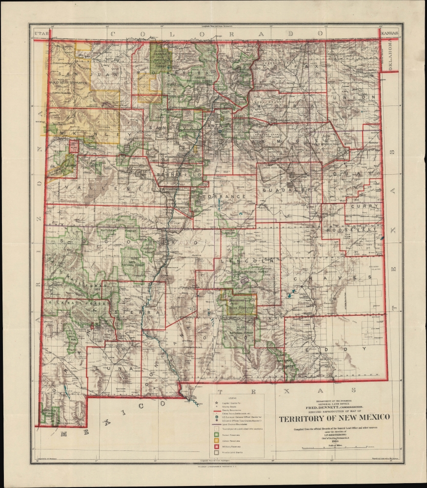
Reduced Reproduction Map of Territory of New Mexico compiled from the official Records of the General Land Office and other sources.
1909 (dated) 21.25 x 18 in (53.975 x 45.72 cm) 1 : 1250000
1909 (dated) 21.25 x 18 in (53.975 x 45.72 cm) 1 : 1250000
Description
An engrossing map of the Territory of New Mexico produced three years before statehood in 1909 by I. P. Berthrong and his colleagues at the U.S. Government's General Land Office. As the title indicates, it is based on an earlier larger-format map of the territory, which was continually updated by the G.L.O. in the late 19th and early 20th century.
A Closer Look
The map highlights private land grants, American Indian reservations (shaded yellow), military bases, forest reserves (shaded green), and the boundaries of land districts (purple outlines). Of greatest interest are the illustrated land grants, including the Tierra Amarilla Grant, the Maxwell Grant, and the Mora Grant. Topographic features are noted throughout, including elevation, waterways, and terrain. Cities and towns, railroads, springs, and archaeological ruins are also indicated.Land Grants in the New Mexico Territory
Before the New Mexico Territory became part of the United States after the Mexican-American War (1846 - 1848), New Mexico (Nuevo México) was a part of the Spanish Empire from 1598 - 1821, and then a territory of independent Mexico from 1821 until the 1846 Treaty of Guadalupe Hidalgo ceded it to the United States. First the Spanish and then the Mexican government granted land concessions to individuals as a reward for meritorious service, as well as communal settlement grants - mostly in an effort to develop the sparsely populated region. More than 150 land grants were awarded by the Spanish and Mexican governments, totaling some 9.3 million acres. After the U.S. gained control of New Mexico, they did not have a process for recognizing the land grants, even though they were guaranteed in the treaty.The Contentious History of the Tierra Amarilla Grant
In 1832, Manuel Martinez petitioned the Governor of New Mexico for a tract of land called Tierra Amarilla, now along the northern border of New Mexico (just east of the 'Jacarilla [Jicarilla] Apache Indian Reservation' here). Situated on the Chama River, Martinez sought the land for agricultural and ranching purposes on behalf of himself, his eight sons, and all who may accompany him. After a dispute between Martinez and the town council of Abiquiu, the closest settlement to the proposed grant, the Provincial Deputation granted the land to Martinez, although the Alcalde of Abiquiu failed to deliver possession of the grant (the paperwork) to Martinez because they feared attacks from the local Native Americans.History Pertaining to the Grant
In 1856, following the annexation of the territory that now makes up New Mexico and Colorado into the United States, Francisco Martinez, one of Manuel Martinez's heirs, filed a petition with the Surveyor General's office seeking confirmation of the Tierra Amarilla Grant. Surveyor General William Pelham investigated Martinez's claim and in a September 25, 1856 decision stated that his office was satisfied thatthe Provincial Deputation had authority under the laws of Mexico to make donations of land to individuals, that the title papers evidencing the grant had been proven to be genuine, and that the Failure of the Alcalde of the Town of Abiquiu to deliver possession to Martinez did not invalidate the grant since such a failure had been satisfactorily explainedand recommended its confirmation by Congress. The grant was confirmed as Private Land Claim No. 3 by an act of Congress approved June 21, 1860.
Land Survey Results
John M. Isaacs, one of the owners of the grant at the time, submitted a request to the Surveyor General on June 30, 1875 that the grant be surveyed in order that a patent might be issued. After another legal battle, the grant was surveyed by Deputy Surveyors Sawyer and McBroom in July 1876. The survey concluded that 594,515.55 acres were contained within the grant and that part of said grant lay within the State of Colorado. On February 21, 1881, the grant was patented to Francisco Martinez.General Land Office Maps of New Mexico
The General Land Office began producing both large and reduced format maps of the New Mexico Territory from as early as 1879 through 1911, just before New Mexico became a state. Numerous editions were published, with each subsequent edition illustrating a greater degree of detail throughout the state. Compared with an 1896 manifestation of the map also sold by us, the present work reduces the focus on private land grants (some of which had still not been well demarcated at the end of the 19th century) and instead reflects the designation of more lands as national forests as well as the greater development of towns and railroads.Publication History and Census
This map was compiled and drawn by Andrew F. Dinsmore and traced and lettered by William Bauman, under the direction of Ithamar P. Berthrong. It was printed by the Eckert Lithographing Co. This map is well represented in institutional collections but is rare on the private market.CartographerS
Ithamar Parsons Berthrong (February 26, 1853 - July 29, 1936) was an American surveyor, inventor, and draftsman active with the General Land Office of the U.S. Department of the Interior. Berthrong was born in Rochester, New York. He was made chief of the drafting division on March 23 of 1907. He is associated with many of the most important early 20th century maps issued by the GLO, among them, important maps of Arizona, Colorado, Wyoming, Oregon, Washington, and more. More by this mapmaker...
Andrew F. Dinsmore (1843 - 1925) was a draughtsman and cartographer who worked for the U.S. Government's General Land Office, working his way up to Principal Draughtsman by the early 20th century. As a result, he was involved in the production of many of the G.L.O.'s hallmark maps of the late 19th and early 20th century. Dinsmore was born in Michigan and served in the U.S. Civil War, achieving the rank of Corporal (he is buried in Arlington National Cemetery). He looks to have resided in Detroit for a period after the war, but by 1868, he had relocated to Washington, D.C. In city directories, his occupation is listed variously as printer, draughtsman, or government clerk, but at any rate began producing maps for the G.L.O. by 1876 and continued to do so until soon before his death. Learn More...
Eckert Lithographing Company (c. 1907 - 1918) was a printer active in Washington D.C. The firm appears to have worked exclusively for the U.S. Government, particularly the General Land Office and the U.S. Geological Survey. Learn More...
The General Land Office (GLO) (1812 - 1946) was an independent agency of the United States government responsible for public domain lands in the United States. Created in 1812, it took over functions previously conducted by the Department of the Treasury. The GLO oversaw the surveying, platting, and sale of public lands in the western United States. It also administered the Preemption Act of 1841, which allowed individuals who were already living on federal land to purchase up to 160 acres of land before it was offered for sale to the general public, if they met certain requirements. Following the passage of the Homestead Act in 1862, which was also administered by the GLO, claims under the Preemption Act sharply decreased. The GLO became a part of the newly-created Department of the Interior in 1849. In 1891 Grover Cleveland and Congress created 17 forest reserves, due to public concern over forest conservation, which were initially managed by the GLO, until they were transferred to the Forest Service in 1905. In 1946 the Government Land Office was merged with the United States Grazing Service to become the Bureau of Land Management. Today the Bureau of Land Management administers the roughly 246 million acres of public land remaining under federal ownership. Learn More...
Condition
Very good. Light wear along original fold lines. Closed margin tear professionally repaired on verso.
References
OCLC 367389133.