This item has been sold, but you can get on the Waitlist to be notified if another example becomes available, or purchase a digital scan.
1838 Hood Map of the Territory of Oregon (Oregon, Washington)
TerritoryOfOregon-hood-1838-2$500.00

Title
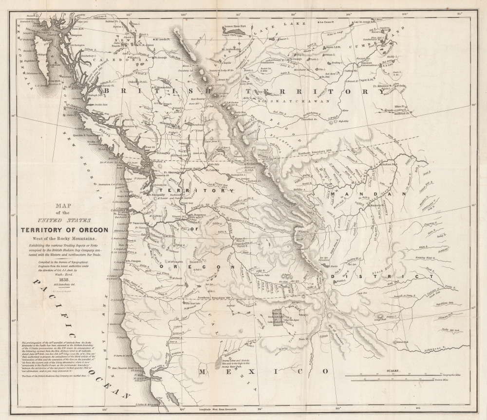
Map of the United States Territory of Oregon West of the Rocky Mountains, Exhibiting the various Trading Depots or Forts occupied by the British Hudson Bay Company, connected with the Western and northwestern Fur Trade.
1838 (dated) 18 x 21 in (45.72 x 53.34 cm) 1 : 1000000
1838 (dated) 18 x 21 in (45.72 x 53.34 cm) 1 : 1000000
Description
This is the landmark 1838 map of the Oregon Territory by Captain Washington Hood, a founding member of the Corps of Topographical Engineers. This map was used for congressional debates of the status of the Oregon Territory, both regarding its position within the United States and in international disputes with Great Britain - the Oregon Question or 54°40′ Debate.
Cartographically, the map features several interesting elements. The Great Salt Lake or the Youta or Lake Bonneville, is curiously oblong in shape. The Gourd River southwest of Salt Lake becomes the Buenaventura River, flowing into 'Swamp Lakes and Islands'. A second Buenaventura River runs north into Monterey Bay. The Buenaventura is the last incarnation of the apocryphal River of the West, a long sought-after speculative alternative to the Northwest Passage. Various posts of the British Hudson's Bay Company as well as the American Fur Company are noted throughout. The map also shows Lewis and Clark's route from Missouri headwaters to 'Canoe Camp' near the Lewis (Snake) River. Of note, the complex river system throughout is illustrated in detail.
A Closer Look
Prepared to 'illustrate the report of Senator Linn on a Bill to authorize the President to occupy the Oregon Territory', this map covers present day Oregon, Washington, Idaho, Montana, Wyoming, California, Utah, Nevada, and British Columbia. Based on Arrowsmith's 1834 map, with relevant updates, it extends from the Dixon Entrance in Canada south along the Pacific coast to Monterey Bay and from the Pacific Ocean eastward to the Rocky Mountains. The map predates the official establishment of the Oregon Territory, and, unlike Arrowsmith's map, sets the northern boundary along the 49th parallel as per the 1818 compromise, while the southern border reflects the boundary settled in Addams-Onis Treaty of 1819.Cartographically, the map features several interesting elements. The Great Salt Lake or the Youta or Lake Bonneville, is curiously oblong in shape. The Gourd River southwest of Salt Lake becomes the Buenaventura River, flowing into 'Swamp Lakes and Islands'. A second Buenaventura River runs north into Monterey Bay. The Buenaventura is the last incarnation of the apocryphal River of the West, a long sought-after speculative alternative to the Northwest Passage. Various posts of the British Hudson's Bay Company as well as the American Fur Company are noted throughout. The map also shows Lewis and Clark's route from Missouri headwaters to 'Canoe Camp' near the Lewis (Snake) River. Of note, the complex river system throughout is illustrated in detail.
Historical Context
In 1818, United States and Britain agreed to joint occupancy of the Oregon Country. Both the British, in the name of the Hudson Bay Company, and the Americans, championed by John Jacob Astor's Pacific Fur Company, were eager to claim monopolistic right over the region. Astor's establishment of Fort Astoria on the Columbia River, identified here, only served to further tensions with the Northwest Company - the Pacific subsidiary of the Hudson Bay Company. The dispute would escalate, giving rise to the Oregon Boundary Dispute and the American expansionist slogan 'Fifty-four Forty or Fight!'. The dispute was not resolved until the 1846 Oregon Treaty which, through concessions on both sides, formally set the boundary at the 49th parallel.54-40 or Fight! American Claims to British Columbia
Following the transcontinental crossing of North America by the British Northwest Company sponsored explorer Alexander MacKenzie (1792 - 1793) and the American expedition of Lewis and Clark up the Missouri to the mouth of the Columbia River (1804 - 1806), it became apparent that control of the fur and resource rich Pacific Northwest would bring great wealth and power to whoever could assert sovereignty. The American tycoon John Jacob Astor, with the permission of President Thomas Jefferson, was the first to attempt a permanent trading colony in the region, founding Astoria on the Columbia River in 1811. This quickly led to a confrontation with the established British-Canadian Northwest Company over this valuable territory. Americans in the 1820s through the 1840s argued that most of the Pacific Northwest should be part of the United States as a legacy of the 1803 Louisiana Purchase. England, on the other hand, argued for residual claims to the region derived from the MacKenzie Expedition and its fur trading empires: The Northwest Company and the Hudson Bay Company. The Oregon Dispute, as it came to be known, became an important geopolitical issue between the British Empire and the United States, especially after the War of 1812. Americans adopted the slogan '54-40 or Fight!' until the Oregon Question was finally resolved roughly along the current border by the 1846 Oregon Treaty.Publication History and Census
This map was compiled in the Bureau of Topographical Engineers from the latest authorities under the direction of Col. J. J. Abert. The engraving was executed by by W. I. Stone after M. H. Stansbury. According to Senator Linn, this map was 'believed to be the most correct and furnishes the most recent and authentic information of any yet published'. The map accompanied the historically important Report of Mr. Linn, Senate Document No. 470, 25th Congress, 2nd Session, dated June 6, 1838, to Accompany Senate Bill No. 206, to authorize the President to occupy the Oregon Territory, and was later re-issued in other reports. Well represented in institutional collections, but scarce on the market.CartographerS
Washington Hood (February 2, 1808 – July 17, 1840) was American army officer in the Corps of Topographical Engineers. Hood was born in Philadelphia, Pennsylvania, the son of John McClellan Hood, a wholesale grocer. Hood attended West Point, from which he was the 500th graduate, matriculating with in the class of 1827. Between 1831 and 1846 he completed various topographical surveys in Missouri and Florida (Seminole Wars?). He next worked with Robert E. Lee measuring the Ohio-Michigan line. In 1836, Hood resigned his military commission to work as a private civil engineer. He spent much of 1837 in Cuba, where he performed railroad work. He rejoined the military as a Captain in 1838 and in that year produced his landmark map of Oregon territory. In 1839, President Van Buren sent him to survey the Oklahoma Shawnee lands between the Arkansas and Missouri River. During this assignment, he contracted an unknown illness from which he died less than a year later. A large archive of his important sketches and manuscripts are preserved at the Winterthur Library in Delaware and Beinecke Rare Book Library, at Yale. More by this mapmaker...
Howard Stansbury (February 8, 1806 - April 13, 1863) was an important surveyor, cartographer, and explorer who did his most important work in Utah during the middle part of the 19th century. Born in New York City, Stansbury trained to be a Civil Engineer. Shorty after getting married to Helen Moody of Detroit in 1827, Stansbury took a position with the United States Topographical Bureau. Under that organization he surveyed the James River in 1836, and the Illinois and Kaskaskia Rivers in 1837. In 1838, he oversaw the construction of a road from Milwaukee to the Mississippi River. Later in 1838, when the U.S Corps of Topographical Engineers was created, he joined as a first Lieutenant. With the Topographical Engineers he surveyed the Great Lakes, the harbor of Portsmouth, New Hampshire, and constructed Florida's Carysfort Reef Lighthouse. During the Mexican-American War he constructed fortification in the Dry Tortugas at the westernmost point on the Florida Keys. Upon achieving the rank of Captain, Stansbury received a commissioned to head a survey of the Great Basin that would ultimately become the crowning achievement of his career. His assignment was to survey the emigrant trails to California, including the Oregon Trail, as well as the Great Salt Lake, and report on the status of the growing Mormon Community in Salt Lake City. Working with J. W. Gunnison and Alfred Carrington, a Mormon scout, Stansbury produced a masterful survey of the region that had a lasting effect not only on the development of the Great Basin, but on the development of the west in general. Upon completion of his survey, Stansbury set out on the road to Washington, completing another important survey in the process. On the way, he fell off his horse, taking an injury from which he never fully recovered. Following the presentation of his report to Congress, Stansbury was charged with additional survey work around the Great Lakes. Upon the outbreak of the American Civil War, he was assigned to recruitment duties in Ohio and later Wisconsin. Shortly after starting work at this post he suffered an abrupt heart attack and passed away. He is buried in St. Paul, Minnesota. Learn More...
William James Stone (c. 1800 - 1865) was an English-born American engraver, lithographer, and sculptor based in Washington D.C. Stone emigrated to the United States in 1804 where he studied engraving under Peter Maverick (1780 - 1831) in New York. Stone started his firm in Washington D.C. in 1815 where he capitalized on the printing of government maps and documents. His most significant accomplishment is his 1823 facsimile of the Declaration of Independence – probably the most exact and iconic version of that document ever printed. Stone is said to have worked three years on his copy of the Declaration of Independence. Among his cartographic works are Emory's map of Texas and Graham's 1836 map of Provincetown. Stone retired from printing to pursue sculpture in the 1840s. He died in 1865. Learn More...
Source
Report of Mr. Linn, Senate Document No. 470, 25th Congress, 2nd Session, dated June 6, 1838, to Accompany Senate Bill No. 206, to authorize the President to occupy the Oregon Territory, (Washington) 1838.
Condition
Very good. Wear and toning along original fold lines. Verso repairs to fold separations. Lower right margin reinstated.
References
Wheat, Carl Irving, Mapping the Transmississippi West, 1540-1861 (5 vols), 434.