
This item below is out of stock, but another example (left) is available. To view the available item, click "Details."
Details
1836 A. A. Parker Narrative of Texan Revolution w/ rare Map of Texas
1836 (dated) $7,500.00
1846 Bradford Map of the Republic of Texas (after Austin)
Texas-bradford-1846$1,250.00

Title
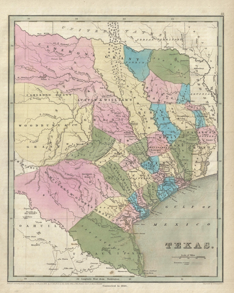
Texas.
1846 (dated) 15 x 12 in (38.1 x 30.48 cm) 1 : 2900000
1846 (dated) 15 x 12 in (38.1 x 30.48 cm) 1 : 2900000
Description
This is Thomas Gamaliel Bradford's important 1846 map of Texas, issued at the end of the Republic of Texas period and of the Mexican American War (1846 - 1848). The map covers the eastern three-fourths of modern Texas, extending from the Red River to the Rio Grande and from Mexico to Lake Sabine and the United States.
Bradford's maps of Texas, published in various sizes and editions from about 1838 to 1847 were regularly updated and, as a whole, offer an overview of Texas from its declaration of independence from Mexico in 1836 to its 1846 decision to join the United States. The present map is late in the series, being issued in the final days of the Republic just prior to being annexed into the United States and the beginning of the Mexican American War.
Bradford's map of Texas closely follows the 1846 final edition of Stephen F. Austin's Map of Texas and is, indeed, the only contemporaneous derivative of the Austin map reasonably obtainable. Like Austin's own map, it occupies a central place in the history of Texas, being widely distributed throughout the United States. With its appended text extolling the virtues and climate of Texas, this readily available map significantly influenced the Anglo-American settlement of Texas and ultimately the Annexation.
Like the Austin map, early editions of Bradford's map illustrate various empresario grants, including Austin's own. These are still apparent on the present map, but have overlaid with the distinguishing characteristics of an increasingly developed country, including the beginnings of a sophisticated county structure, newly established roads, and other features.
A Closer Look
It names both newly established counties and the empresario land grants following Stephen F. Austin's map of Texas issued in the same year.Bradford's maps of Texas, published in various sizes and editions from about 1838 to 1847 were regularly updated and, as a whole, offer an overview of Texas from its declaration of independence from Mexico in 1836 to its 1846 decision to join the United States. The present map is late in the series, being issued in the final days of the Republic just prior to being annexed into the United States and the beginning of the Mexican American War.
Bradford's map of Texas closely follows the 1846 final edition of Stephen F. Austin's Map of Texas and is, indeed, the only contemporaneous derivative of the Austin map reasonably obtainable. Like Austin's own map, it occupies a central place in the history of Texas, being widely distributed throughout the United States. With its appended text extolling the virtues and climate of Texas, this readily available map significantly influenced the Anglo-American settlement of Texas and ultimately the Annexation.
Like the Austin map, early editions of Bradford's map illustrate various empresario grants, including Austin's own. These are still apparent on the present map, but have overlaid with the distinguishing characteristics of an increasingly developed country, including the beginnings of a sophisticated county structure, newly established roads, and other features.
Publication History and Census
The 1838 copyright on this map corresponds to the first edition - as Bradford did not want to invest to update the legal registration despite numerous annual updates. A note under the bottom border identifies this map as being corrected to 1846. It was engraved by George Washington Boynton and published as plate no 42 in the 1846 large format edition of Bradford and Goodrich's A Universal Illustrated Atlas.CartographerS
Thomas Gamaliel Bradford (1802 - 1887) was born in Boston, Massachusetts, where he worked as an assistant editor for the Encyclopedia Americana. Bradford's first major cartographic work was his revision and subsequent republishing of an important French geography by Adrian Balbi, Abrege de Geographie published in America as Atlas Designed to Illustrate the Abridgment of Universal Geography, Modern and Ancient. Afterwards Bradford revised and expanded this work into his own important contributions to American cartography, the 1838 An Illustrated Atlas Geographical, Statistical and Historical of the United States and Adjacent Countries. Bradford's cartographic work is significant as among the first to record Texas as an independent nation. In his long career as a map publisher Bradford worked with William Davis Ticknor of Boston, Freeman Hunt of New York, Charles De Silver of Philadelphia, John Hinton, George Washington Boynton, and others. We have been able to discover little of Bradford's personal life. More by this mapmaker...
George Washington Boynton (fl. c. 1830 - 1850) was a Boston based cartographer and map engraver active in the first half of the 19th century. Boynton engraved and compiled maps for numerous publishers including Thomas Bradford, Nathaniel Dearborn, Daniel Adams, and S. G. Goodrich. His most significant work is most likely his engraving of various maps for Bradford's Illustrated Atlas, Geographical, Statistical, and Historical, of the United States and the Adjacent Countries and Universal Illustrated Atlas. He also engraved for the Boston Almanac. In 1835, Boynton is listed as an employee of the Boston Bewick Company, an engraving, stereotype, and printing concern based at no. 47 Court Street, Boston. Little else is known of his life. Learn More...
Source
Bradford, T. G. and Goodrich, S. G., A Universal Illustrated Atlas, exhibiting a Geographical, Statistical, and Historical view of the World, (Boston: Charles D. Strong) 1846.
Condition
Very good. Even overall toning.
References
OCLC 78745485.