
This item below is out of stock, but another example (left) is available. To view the available item, click "Details."
Details
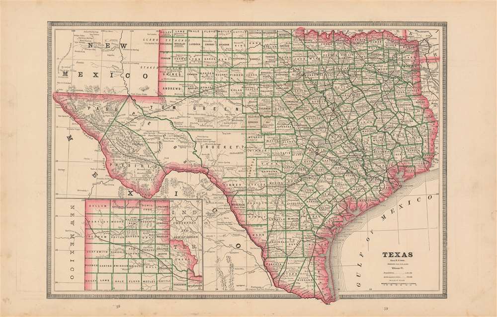
1939 Cram Wall Map of Texas
1939 (dated) $450.00
1883 Cram Map of Texas
Texas-cram-1883$75.00

Title
Texas.
1883 (undated) 11.75 x 17 in (29.845 x 43.18 cm) 1 : 3100000
1883 (undated) 11.75 x 17 in (29.845 x 43.18 cm) 1 : 3100000
Description
This is an 1883 map of Texas, most likely from Cram's 'Unrivaled Family Atlas of the World'. The state is outlined in red: counties are bordered in green. Reeves County is not yet shown. Tom Green, Pecos, Presidio and El Paso Counties are still not subdivided. Topographical features and rivers are shown with hachure. Railroads are clearly noted. Towns, and even major ranches are also located. Interestingly, greer County is shown as part of Texas. (Even an 1896 Supreme Court ruling was insufficient in settling ownership of the land in question.)
Publication History and Census
While examples of Cram's map of Texas appear in a number of institutions, we do not see this one - page numbers 58 and 59, with these particular verso maps - accurately catalogued. Various editions of the map do appear on the market.Cartographer
George Franklin Cram (May 20, 1842 - 1928) was an American map publisher active in the late 19th and early 20th centuries. During the American Civil War, Cram served as a staff cartographer for the Union General Ulysses S. Grant and participated in Sherman's 'March to the Sea'. In 1867, after being discharged from the army, George Cram moved to Chicago, where he founded 'Blanchard and Cram' with his uncle Rufus Blanchard Evanston. Blanchard and Cram was a supply house for the book trade - though they also published a few maps during this period. This short lived business was destroyed in the 1871 by the Great Chicago Fire. After the fire, recognizing a business opportunity in the burgeoning railroad industry, Cram reinvented himself as cartographic publisher, opening the Cram Map Depot. Like fellow Chicago publisher Rand McNally, Cram took advantage of the economical wax engraving processes to inexpensively produce maps in vast quantities. His signature publication, the Unrivaled Atlas of the World became the world's best-selling atlas and was published from the 1880s to 1952. On retiring in 1921, Cram sold his company to Edward A. Peterson of the National Map Company (Scarborough Company). Peterson moved the company to Indianapolis where, following Cram's death, he rebranded the National Map Company as the George F. Cram Company, surely thinking to capitalize on the established identity of the firm. In 1930 he entered the globe market for which the firm was best known from the mid-20th century. In time the firm expanded globally passing becoming a major concern. Loren B. Douthit became company president in 1968 and the Douthit family ran the business until Herff Jones, Inc., bought the company in 2005. More by this mapmaker...
Source
Cram's Unrivaled Family Atlas of the World. Copyright 1883 by Geo. F. Cram. Chi. Ill. A.C. Shewey & Co., 264 Wabash Avenue, Chicago, Rushville, Ind.
Condition
Very good condition. Two maps on verso.
References
Rumsey 0210.000.