This item has been sold, but you can get on the Waitlist to be notified if another example becomes available, or purchase a digital scan.
1841 Day and Haghe Map of the Republic of Texas (Illustrating Conflicting Borders)
Texas-dayhaghe-1841$3,000.00

Title
A New Map of Texas 1841.
1841 (dated) 17.25 x 16.25 in (43.815 x 41.275 cm) 1 : 4600000
1841 (dated) 17.25 x 16.25 in (43.815 x 41.275 cm) 1 : 4600000
Description
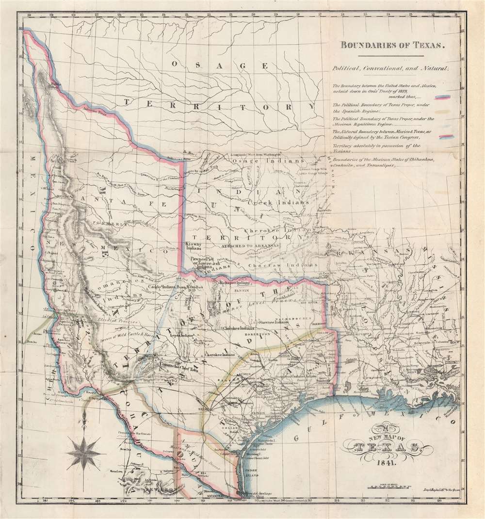
An 1841 map of the Republic of Texas by Nicholas Doran Maillard, who hated Texas and Texans pretty much more than anything. Despite Maillard's feelings toward Texas, the map by Day and Haghe is a truly remarkable work unique in addressing Texas's boundaries and claims. It also notes with detail American Indian settlements throughout and offers notes and annotations on fortifications, terrain, mines, and more. Significantly, and progressively for the time, much of the land beyond coastal Texas is defined as the 'Territory of the Texan Indians'.
Texas Borders Defined
As the subtitle suggests, the map employs color coding to indicate the 'political, conventional, and natural' boundaries. More than any other cartographer, he restricts the 'true' boundaries of Texas to 'Territory absolutely in possession of the Texans', a comparatively narrow strip of land south of Austin and extending along the Gulf Coast from Corpus Christi to the Sabine River. Other color coding defines the line of the Adams-Onís Treaty of 1819, Spanish boundaries, Mexican boundaries, and other boundaries claimed by Mexican states.The Map
This map was compiled by the excellent British firm of William Day and Louis Haghe to accompany Doran's history of the Republic of Texas, a work known more for its vitriol towards Texans than historical facts. Nonetheless, as Streeter pointed out, 'The map is the best feature of the book, for among its classifications shown in colored lines are the political boundaries of Texas under Spain and the territory now 'absolutely in the possession of the Texians'.' And indeed, in the words of Dorothy Sloan, this 'is one of those strange anomalies in today's Texana market, in that the map is probably worth more than the book.'Maillard's Vitriol
Nicholas Doran Maillard was a British barrister who moved to Texas in 1840, settling in Richmond. He immediately began editing the Richmond Telescope. By all reports, Maillard was popular in Richmond, whose citizens, impressed with his education, fine British manners, and mixology skills, welcomed him heartily. It remains unclear what happened to Maillard in Texas, but he left by 1841, apparently bitter with hatred towards all things Texan, feelings that come across clearly in his 1842 book, The History of the Republic of Texas (London: Smith, Elder, and Co.). Some modern commentary on his verbiage we could not resist quoting:- Basic Texas Books, 134: 'The most vitriolic denunciation of the Republic of Texas [comprising] a compendium of everything bad that could be claimed about Texas and Texans of those times.'
- Graff, 2663: 'Texas cut down to size a difficult feat even in 1842.'
- Streeter, 1422: 'Though this account of Texas has little value as a history because of Maillard's extreme bias, it should be included in Texas collections as an example of what can be said about Texas by one who hates it.... What wounded Maillard's ego during the six months in 1839 he spent in Texas is not known, but it has caused him to characterize Texas (p. 206) as 'a country filled with habitual liars, drunkards, blasphemers, and slanderers, sanguinary gamesters and cold-blooded assassins' and more to the same effect. Stephen F. Austin is referred to, at page 30, as 'the prince of hypocrites,' and James Bowie, at page 104, as 'monster'.... Incidentally, at page vi, Maillard speaks of himself as 'an impartial historian.'
Republic of Texas
The Republic of Texas was a short-lived nation established in March of 1836 when it ceded from Mexico. Following the independence of Mexico from Spain, the American Stephen Fuller Austin led a group of 300 Empresarios to settle Texas, near Austin, where they received a grant from the Mexican government. As more Americans moved to Texas, resentment and strife began to build between the American settlers and Mexican authorities. This and other factors ultimately led to the Texan Revolution in 1835 and the declaration of Texan independence in 1836. Texas remained an independent republic until it joined the United States 10 years later in 1846.Texas Borders
The borders of the Republic of Texas were in dispute from the earliest days of the Texan Revolution. The Republic-claimed borders followed the Treaties of Velasco between the newly created Texas Republic and Mexican leader, Antonio López de Santa Anna. The treaties established an eastern boundary following the 1819 Adams-Onís Treaty between the United States and Spain, which established the Sabine River as the eastern boundary of Spanish Texas and western boundary of the Missouri Territory. The Republic's southern and western boundary with Mexico was more nuanced. Texas claimed the Rio Grande del Norte as its western and southernmost border, while Mexico argued for a boundary much further east at the Nueces River. When Texas was annexed into the United States, the agreement followed the Republic claimed boundary, thus absorbing Mexican claimed territory as far west as Santa Fe. This escalated already existing tensions between the United States, the former Republic of Texas, and Mexico, ultimately triggering for the Mexican-American War (1846 -1848).Publication History and Census
This map was drawn and engraved by Louis Haghe (1806 - 1885) and William Day (1797 - 1845) following the first-hand accounts of Nicholas Doran Maillard, who lived in Texas from 1841 - 1842. It was included with copies of, The History of the Republic of Texas (London: Smith, Elder, and Co.). We note no separate examples of the map in the OCLC, but the book is represented in several institutional collections. It is scarce to the market.CartographerS
Day and Haghe (1830 - 1852) was a British lithograph firm founded in 1830 by Louis Haghe (March 17, 1806 - March 9, 1885) and William Day (1797 - 1845). Louis Haghe was born in Tournai, Belgium, the son and grandson of prominent Belgian architects. Haghe had a fondness for watercolor painting and turned his attention to the nascent art of lithography. He set up his first lithographic press in Tournai, but did not truly prosper until he moved to London in 1823. There, in 1830, he partnered with William Day to found 'Day and Haghe.' Day and Haghe engraved and printed lithographs detailing hunting scenes, architecture, topographical views, genre depictions, city views, and more. They pioneered the new techniques for chromolithography as well as issuing hand-tinted lithographs. In 1837, Day and Haghe became the only lithographers to receive the prestigious Royal Warrant wherein they were appointed 'Lithographers to the Queen'. The firm is most famous for producing the 250 images for David Roberts' The Holy Land, Syria, Idumea, Arabia, Egypt, and Nubia, 1842 - 1849. Although Haghe remained with the company, as early as the 1840, he left most of the management to Day. When William Day died in 1845, the firm's management fell to his son, William Day Jr. Haghe formally left the firm to persue art in 1852, after which the imprint changed to 'Day and Son.' Day and Son went into liquidation in 1867 and was acquired by Vincent Brooks (1815 - 1885). Brooks owned the firm outright, but kept the prestigious Day name, publishing under the imprint of 'Vincent Brooks, Day and Son' until the firm went defunct in 1940. More by this mapmaker...
Nicholas Doran Maillard (1810 - July 7, 1880) was an Irish barrister active in Dublin, Texas, and London in the mid-19th century. Maillard was born in Dublin, Ireland to James Nicholas Maillard and Catherine Stubber. He received a fine education as a barrister and practiced briefly before moving to Texas. He lived and worked as a newspaper editor in Richmond, Texas, near modern-day Houston. He may have remained in Texas for as little as six months. He was known in Robinson for his friendly demeanor, fine British manners, education, and skill at mixology. He left Robinson for London, claiming sick relatives. Within two years of return, he published The History of the Republic of Texas, reviling Texas and the Texan Revolution, while praising Mexico. It remains unclear why he so despised Texas, but likely the work was sponsored by British bankers, who leveraged enormous debt over Mexico, much of which was secured by Texan lands. After published his history, he moved back to Dublin, where he was active as a barrister, editorialist, and pamphleteer. At some point in the 1860s, he began going by his mother's maiden name 'Stubber', possibly for legal purposes. He died in Ireland in the 1880s, having never returned to the Texas he so reviled. Learn More...
Source
Maillard, N. D., The History Of The Republic Of Texas, From The Discovery Of The Country to the Present Time; And The Cause Of Her Separation From the Republic of Mexico. (London: Smith, Elder and Co.) 1842.
Condition
Very good. Some wear on old fold lines. Tear from right margin into upper right text professionally repaired. Slight infill on old folds. Manuscript reinstatement of right border.
References
Howes, W., U.S.iana (1650 - 1950): A Selective Bibliography in which are Described 11,620 Uncommon and Significant Books Relating to the Continental Portion of the United States, M255. Storm, Colton, A Catalogue of the Everett D. Graff Collection of Western Americana, 2663. Streeter 1422.