This item has been sold, but you can get on the Waitlist to be notified if another example becomes available, or purchase a digital scan.
1818 Pinkerton Map of the American Southwest ( California, Louisiana, New Mexico, Texas )
Texas-pinkerton-1818$875.00

Title
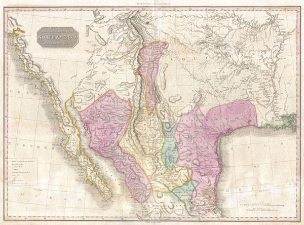
Spanish Dominions in North America Northern Part.
1818 (undated) 20.5 x 28 in (52.07 x 71.12 cm)
1818 (undated) 20.5 x 28 in (52.07 x 71.12 cm)
Description
Possibly the finest commercial map of the American southwest to appear in the early part of the 19th century. Produced by John Pinkerton and based largely on the explorations of Alexander von Humboldt, this map Covers from the San Francisco Bay to the Mississippi Delta and from Lake Timpanagos (Great Salt Lake area) to Veracruz and Guadalajara.
Though ostensibly similar to John Thompson's map of the same region, Pinkerton's map in fact a far different and vastly superior map. The entire map is flush with a level of detail that is nothing short of astounding. Pinkerton utilizes a cleaver engraving technique to represent the vast plains west of the Mississippi. Numerous important Spanish colonial cities and missions are named, including Santa Fe, Albuquerque, and the city of 'Pres del Bejar, Capital of the Province of Texas.' New Mexico is reduced form a formerly vast territory to a relatively narrow strip of land attached to the Rio Norte (now the Colorado River). Much of modern day Texas is part of the Intendancy of San Louis de Potosi. Shows both Lake Timpanagos (Great Salt Lake) and Lake Teguayo (Utah Lake) with some accuracy regarding form. The apocryphal River Buenaventura flows eastward from Utah lake into the Rocky Mountains. In the Great Plains, Pinkerton provides a unusual wealth of detail, some drawn from preliminary accounts of Lewis and Clark, but most derived from other sources. Many of the great rivers systems are shown in considerable detail including notations on portages and navigability. Identifies the hunting grounds of numerous American Indian tribes, including the Apache, Acoma, Pawnee, Delaware, Juma, Comanche, and others. Along the west coast numerous missions are noted including the Mission of San Francisco, the Mission of San Diego, Santa Barbara, San Buenaventura, etc.
All in all a remarkable map and a must for any serious collection focused on the American Southwest. Drawn by L. Herbert and engraved by Samuel Neele under the direction of John Pinkerton. This map comes from the scarce American edition of Pinkerton's Modern Atlas, published by Thomas Dobson & Co. of Philadelphia in 1818.
CartographerS
John Pinkerton (February 17, 1758 - March 10, 1826) was an Scottish writer, historian, and cartographer. Pinkerton was born in Edinburgh, Scotland. He was a studious youth with a passion for the classics. As a young man, he studied at Edinburgh University before apprenticing as a lawyer. Around this time, he began writing, with his first book, Elegy on Craigmillar Castle published in 1776. Pinkerton moved to London in 1781 to pursue his writing career in earnest. He successfully published several works of literature, poetry, and history. Pinkerton proved passionate in his literary and historical writings, but his correspondence with other cartographers has been labeled as aggressive, even insane. In addition to his work as a writer and historian, Pinkerton was one of the leading masters of the Edinburgh school of cartography which flourished from roughly 1800 to 1830. Pinkerton and his contemporaries (Thomson and Cary) redefined European cartography by abandoning typical 18th century decorative elements such as elaborate title cartouches and fantastical beasts in favor of detail and accuracy. Pinkerton's principle work is Pinkerton's Modern Atlas published from 1808 through 1815 with a special American reissue by Dobson and Co. in 1818. Pinkerton relocated to Paris in 1818, where he managed his publishing business until his death in 1826. More by this mapmaker...
Thomas Dobson (1751 - 1823) was an American publisher active in Philadelphia during the late 18th and early 19th centuries. Dobson was born in Edinburgh, Scotland in 1751 and emigrated to Philadelphia c. 1780. In Philadelphia, he established a successful printing business by republishing edited and updated versions of important British reference materials in matching quality but at a much lower price point. He is best known for publishing the first American edition of the Encyclopedia Britannica. He also published America's first Hebrew Bible. Cartographically Dobson's most notable work is 1818 republication of Pinkerton's fantastic Modern Atlas. Learn More...
Source
Pinkerton, J., A Modern Atlas, from the Lates and Best Authorities, Exhibiting the Various Divisions of the World with its chief Empires, Kingdoms, and States; in Sixty Maps, carefully reduced from the Larges and Most Authentic Sources. 1818, Philadelphia, Thomas Dobson Edition.
Condition
Very good condition. Minor discoloration along original centerfold. Minor dampstaining in lower quadrants - see image. Blank on verso.
References
Rumsey 0732.045. Phillips (Atlases) 724. National Maritime Museum, 409.