This item has been sold, but you can get on the Waitlist to be notified if another example becomes available, or purchase a digital scan.
1858 Richardson Map of Texas
Texas-richarson-1859$3,250.00

Title
Richardson's New Map of the State of Texas including Part of Mexico.
1859 (dated) 25.5 x 33.75 in (64.77 x 85.725 cm) 1 : 2300000
1859 (dated) 25.5 x 33.75 in (64.77 x 85.725 cm) 1 : 2300000
Description
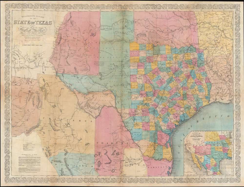
This is the rare 1858 / 59 first edition of the large-format Willard Richardson / Charles DeSilver map of Texas. This is the most influential separately-issued map of Texas on the eve of the American Civil War (1861 - 1865). The map is noteworthy not only for its size and detail, but for its exception breakdown of railroads, both extant and under construction. An inset in the lower right details the proposed route of the Arkansas Railroad.
A Closer Look
The map is derived from the 1857 Bureau of Topographical Engineers survey and to a lesser extent, various railroad surveys, and to a lesser extent Pressler's 1858 Map of the State of Texas. Several important overland routes are noted, including the Apache Trail, the Comanche Trail, and the mail route from San Antonio to San Diego via El Paso. Parts of Mexico are included: Sonora, Chihuahua, Durango, Coahuila, Nueva Leon, and Tamaulipas. Within Texas counties are color coded.Publication History and Census
This map was engraved and copyrighted in 1858, but not released until 1859 when it was offered as separately-sold supplement to Willard Richardson's Texas Almanac. This example features both the 1858 Charles DeSilver copyright and the 1859 date in the title, marking it as the first edition. Subsequent updated and revised editions followed well into the 1870s, with G.W. and C. B. Colton taking over the copyright in 1866. The map is rare, especially in the first edition. Most examples were sold exclusively in Texas, and between harsh frontier conditions and the subsequent American Civil war, most were lost or survive in a poor state. The OCLC notes 3 editions in 9 libraries, but only 2 other examples of the 1859 first edition.CartographerS
Charles Desilver (1815 - May 18, 1876) was an American book and map publisher active during the 19th century in Philadelphia. Desilver, the son of Thomas Desilver of the firm Desilver, Thomas and Co., began is cartographic career as a partner in the firm Thomas, Cowperthwait and Company, the publisher of Samuel Augustus Mitchell's popular New Universal Atlas. Thomas, Cowperthwait and Company was succeeded by Cowperthwait, Desilver and Butler. In 1856, when the previous firm dissolved, Desilver succeeded it by starting his own lithographic firm, acquired Mitchell's copyrights, and began publishing his own variant on the New Universal Atlas. Desilver revised Mitchell's maps with a new grillwork border, his own color scheme, new titles, and some updated political data. Despite a noble pedigree, Desilver's maps did not sell well - possibly because they followed the long and very popular run of Mitchell's own atlases. Desliver continued to publish his atlas until 1859 (though we have heard that he also published an 1862 edition). In 1859 he resold the Mitchell copyrights and printing plates to S. A. Mitchell's son S. A. Mitchell, Jr. The younger Mitchell again updated the plates with his own border and color scheme. He began publishing his own successful atlas in 1860. Desilver continued to operate his firm even after selling the Mitchell copyrights, and his sons Harry and Joseph T., joined the firm in 1875 which was renamed Desilver and Sons. Desilver married Caroline Hill on March 29, 1836, in Philadelphia, with whom he had several children. More by this mapmaker...
Willard Richardson (June 24, 1802 - July 16, 1875) was a Texan newspaperman and publisher active in the mid-19th century. Richards was born in Marblehead, Massachusetts. In 1818, he relocated with his brother to Charleston, South Carolina. Shortly thereafter, his brother died of yellow fever. With the support of a local judge, he attended state collage at Columbia, South Carolina, graduating in 1828. He subsequently moved to Texas in 1837 to work as a surveyor. Within a few years, he returned to teaching, establishing a school in Houston, which he ran for nine years. During this time, he befriended Francis Moore, editor of the Telegraph and Texas Register. Moore traveled to Washington D.C. to cover a presidential campaign, leaving Richardson in charge of the Register. Richardson proved so effective he garnered the attention of the Galveston News owners Wilbur H. Cherry and Benjamin F. Neal, who were looking for a new editor and offered him the position. There he developed a reputation for Whig values and supported the state's rights beliefs of John C. Calhoun. He was also an ardent secessionist. He began publishing the Texas Almanac in 1857. In time he became one of the wealthiest and most powerful newsmen in antebellum Texas. Richardson died in Galveston in 1875. Learn More...
Condition
Good. Professionally restored with some areas of loss along old fold lines reinstated.
References
Rumsey, 5178.000 (1861). Taliferro, H., Cartographic sources in the Rosenberg Library, 322A, 322B. Day, James M., Maps of Texas 1527-1900: the map collection of the Texas State Archives, #1012 (1860 edition) and 428. Winkler 1373x. Phillips (Maps) 846. Library of Congress, G4030 1859 .D4.