This item has been sold, but you can get on the Waitlist to be notified if another example becomes available, or purchase a digital scan.
1970 Civic Education Service Map of Africa
ThreeAfricas-civiceducation-1970$175.00

Title
Africa. Headline-Focus Wall Map 14. The 3 Africas.
1970 (dated) 36.25 x 27 in (92.075 x 68.58 cm) 1 : 11520000
1970 (dated) 36.25 x 27 in (92.075 x 68.58 cm) 1 : 11520000
Description
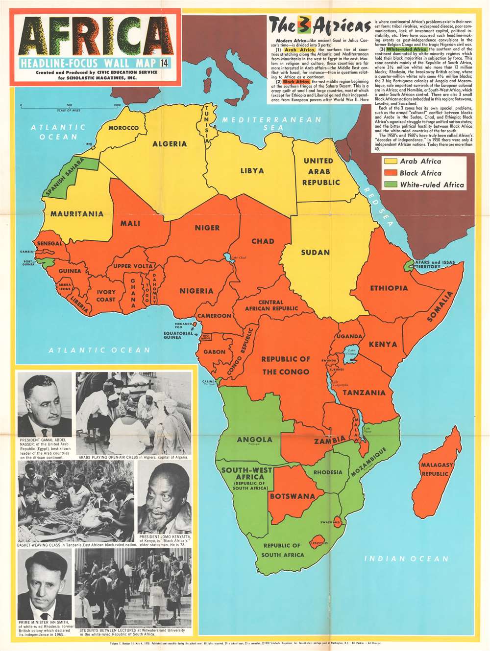
This 1970 Civic Education Service map of Africa divides the continent into three parts: 'modern Africa' is made up of 'Arab Africa', 'Black Africa', and 'White-ruled Africa'. The countries that create each of these regions are shaded either yellow ('Arab Africa'), orange ('Black Africa'), or green ('White-ruled Africa'), and each region is described very succinctly in a text box situated in the upper right corner.
The Three Africas
Arab Africa' is described as the 'northern tier of countries' that are 'far more interested in Arab affairs - the Middle East conflict with Israel, for example - than in questions relating to Africa as a continent', while 'Black Africa' is 'the vast middle region…where continental Africa's problems exist in their rawest forms'. 'White-ruled Africa', the 'southern end of the continent', is run by 'white-minority regimes which hold their black majorities in subjection by force'. It is noted that three small Black African nations are in this region as well: Botswana, Lesotho, and Swaziland. A passing reference is also made to the '[two] big Portuguese colonies of Angola and Mozambique, sole important survivals of the European colonial era in Africa'. Printed images of President Gamal Abdel Nasser of the United Arab Republic, President Jomo Kenyatta of Kenya, and Prime Minister Ian Smith of white-ruled Rhodesia, are situated in the lower left corner amid scenes of life in the Republic of South Africa, Tanzania, and Algeria.A Short Analysis
This system, one based only on race, presents a viewpoint that is contentious today. Colonialism as a phenomenon is only referenced explicitly twice, with a third oblique reference made to Rhodesia being 'the breakaway British colony'. Another glaring omission is the manner in which apartheid in South Africa and Southwest Africa is addressed. References are made to the 'subjection by force' of the black majority populations of the white-ruled countries, but no further details are provided. Race in the United States in 1970, only a few years removed from landmark integration Supreme Court decisions and civil rights legislation, was at the forefront of public thought and debate, and yet here is a map created as an educational piece for students across the country that focuses on racial divisions in Africa providing neither criticism nor insight. Fifty years after this map's original publication these are questions that are still being raised and, sometimes violently, debated.Publication History and Census
This map was created and published by the Civic Education Service in 1970. Examples are scarce and we have traced no other reference to this map.Cartographer
The Civic Education Service (fl. c. 1939 - 1945, 1963 - 1972) was a publishing firm based in Washington, D.C. that produced maps and other visual material for academic purposes. Our research has led us to believe that an organization known as the Civic Education Service existed from c. 1939 - c. 1945 (during World War II) and from c. 1963 - c. 1972. We have been unable to determine if this is the same organization that was closed for almost twenty years, or if the organization that published maps and other educational materials in the 1960s and 1970s was unrelated to the Civic Education Service that published books, maps, and other materials during World War II. More by this mapmaker...
Condition
Good. Wear and toning along original fold lines. Verso repairs to fold separations. Exhibits small areas of loss at fold intersections. Blank on verso.