1908 Survey of India Linguistic Map of Nepal, Tibet, and Environs
TibetanDialects-surveyofindia-1908$650.00

Title
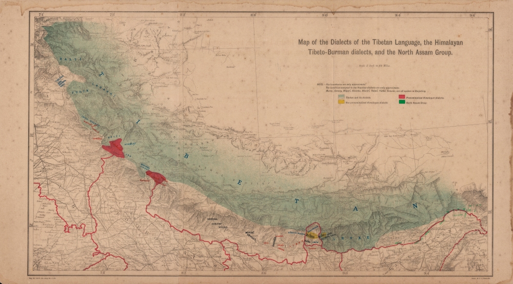
Map of the Dialects of the Tibetan Language, the Himalayan Tibeto-Burman dialects, and the North Assam Group.
1908 (dated) 12.75 x 22.25 in (32.385 x 56.515 cm) 1 : 4055040
1908 (dated) 12.75 x 22.25 in (32.385 x 56.515 cm) 1 : 4055040
Description
A fascinating linguistic map of the Himalayas, focusing on Nepal, Sikkim, Bhutan, and environs produced in 1908 by the Survey of India when Nepal was still closed to foreign visitors. It provides insight on the cultural and linguistic complexity of the Himalayas, which at the time formed the furthest edge of the British Empire's influence in Inner Asia.
This region is notable, even exceptional, both for the variability of languages spoken, even within a small geographic area, and the wide range of language groups which intersect there. Sino-Tibetan (or Trans-Himalayan), Indo-European, Kra–Dai, and Austroasiatic languages are all spoken in the Himalayas. As indicated here, even within a single language family, such as Tibetan, there was wide variation by region and dialect (and this map does not even extend to other subgroups such as Amdo and Khams Tibetan). For example, the Ladakhi–Balti languages seen at left are atonal, while other Tibetic languages and dialects in the Himalayas are tonal.
The difficulties in ensuring uniformity across the culturally diverse and complex subcontinent have led the project to be criticized, while its results have become a tool for various ethno-linguistic groups seeking recognition or territorial modifications. From the 1980s, the Indian government has on several occasions sought to recreate, modify, and otherwise supplement the original survey, but these have all been incomplete (in part because of fears that the survey could stoke intercommunal discrimination and tensions). In 2010, a non-profit organization launched the People's Linguistic Survey of India, a volunteer effort focusing initially on the Himalayas region.
A Closer Look
Ranging from Srinagar and Jaipur in the west to Assam and what is now Arunachal Pradesh in the east, this map takes in the Himalaya region, including Nepal, Bhutan, and Sikkim. Railways, roads, rivers, mountains (with elevation), cities, and towns are indicated, but the main focus is on languages and dialects, which are denoted with color shading and overprint. Many of these languages and dialects are now endangered, spoken by a shrinking number of elderly, rural residents.This region is notable, even exceptional, both for the variability of languages spoken, even within a small geographic area, and the wide range of language groups which intersect there. Sino-Tibetan (or Trans-Himalayan), Indo-European, Kra–Dai, and Austroasiatic languages are all spoken in the Himalayas. As indicated here, even within a single language family, such as Tibetan, there was wide variation by region and dialect (and this map does not even extend to other subgroups such as Amdo and Khams Tibetan). For example, the Ladakhi–Balti languages seen at left are atonal, while other Tibetic languages and dialects in the Himalayas are tonal.
The Linguistic Survey of India
George Abraham Grierson (1851 - 1941) was born near Dublin to a family of printers and publishers. He qualified for the Indian Civil Service while studying at Trinity College, Dublin, where he was a student of Orientalist Robert Atkinson. Grierson proved to be a gifted student of Indian languages, which prepared him well for his career in India. While working for the Indian Civil Service and afterwards, he was an active scholar of Indian languages, regularly attending conferences and publishing research. After years of lobbying, Grierson was able to overcome concerns about cost and feasibility to convince the Government of India to finance the project, which began in 1894 and continued until 1928. In all, eleven massive volumes, most divided into multiple parts, were published, and copious notes, recordings, and other materials have been useful to subsequent researchers.The difficulties in ensuring uniformity across the culturally diverse and complex subcontinent have led the project to be criticized, while its results have become a tool for various ethno-linguistic groups seeking recognition or territorial modifications. From the 1980s, the Indian government has on several occasions sought to recreate, modify, and otherwise supplement the original survey, but these have all been incomplete (in part because of fears that the survey could stoke intercommunal discrimination and tensions). In 2010, a non-profit organization launched the People's Linguistic Survey of India, a volunteer effort focusing initially on the Himalayas region.
Publication History and Census
This map appeared in the Linguistic Survey of India, Vol. III, Part 1, overseen by Grierson and published by the Superintendent of Government Printing in 1909, though the notation at bottom suggests that the map itself was printed in 1908, at the Survey of India Office (S.I.O.) in Calcutta. The map is not independently cataloged with any institution and has no known history on the market, while the entire Linguistic Survey of India and its constituent volumes are held by major research institutions worldwide.Cartographer
Survey of India (1767 - Present) is India's central engineering agency in charge of mapping and surveying the country. It was founded in 1767 by Major James Rennell, who took the post of first Surveyor General, with the mission to map and consolidate the territories of the British East India Company. The Survey undertook the Great Trigonometrical Survey between 1802 and 1852 in an attempt to accurately measure the Indian Subcontinent - considered one of the greatest feats of mapping of all time. It also sponsored clandestine surveys, at times disguised as Buddhist pilgrims, to infiltrate and map Tibet, then a closed country. With India's independence in 1947, the Survey was folded into the new Indian government, which it remains part of to this day. More by this mapmaker...
Source
Grierson, G. A., Linguistic Survey of India, Vol. III, Part 1..., (Calcutta: Superintendent of Government Printing) 1909.
Condition
Average. Dark toned. Foxing throughout with soiling in margins and wear along edge. Major dissections on vertical fold lines repaired on verso, and stabilized.
References
OCLC 491445936 (entire book).