
1561 Ruscelli Map of New England and the Maritimes (A true 1561 First Issue)

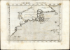
Tierra Nueva.
One of the First Acquirable Maps of the North American East Coast in its earliest issue.
- Digital Map Information
- Suitable for large format printing
- Full resolution TIFF file
- ICC color profile embedded
- Delivered instantly via download link
One of the First Acquirable Maps of the North American East Coast in its earliest issue.
This is the first state, first edition, of Girolamo Ruscelli's 1561 map 'Tierra Nueva', an early and influential map of what would become New England and the Canadian Maritime Provinces. It is among the earliest acquirable maps to cover the eastern coastline of North America. The map spans from upper Florida northwards past Cabo de Santa Maria to Larcadia (Kitty Hawk), Angoulesme (New York Harbor), Nova Scotia, and Labrador. The map is a further development of the 1548 Gastaldi map of the same region. While the Gastaldi was limited entirely to the coastline, Ruscelli's map attempted to show a network of rivers and is among the first regional maps to show mountains in the interior of North America.Discoveries and Place Names
The map represents an attempt to reconcile the discoveries of Giovanni Verrazano with those of Jacques Cartier. The southern placenames tend to derive from Verrazano. 'L'Arcadia', named by Verrazano because of its forested beauty, is now assumed to have been somewhere near Kitty Hawk. In the subsequent decades, the term 'Larcadia' was applied further and further north until it came to refer to the coasts of Maine and the Canadian Maritimes. Angoulesme was the place name Verrazano gave to New York Harbor (although Andre Thevet, writing in 1550, also takes credit for the term). Flora most likely represents the south coast of Long Island. Brisa is almost certainly Block Island. Pt. Refuge is Narragansett Bay. The Chesapeake Bay, Delaware Bay, Cape Cod, and Boston Harbor are notably absent, as Verrazano was forced too far out to sea for fear of reefs to see their entrances.The point where Verrazano left off did not extend far enough north to be easily connected with the discoveries of Cartier, who sailed south from Labrador into the Gulf of the St. Lawrence. Cartier never sailed south of Prince Edward Island. Verrazano barely skirted the southern tip of Nova Scotia. Thus, the map's rapid transition from the southern extent of New England directly to Cape Breton Island and the eastern Maritimes. The map does present one of the earliest representations of the coast of Maine around the Penobscot River, Nova Scotia, Newfoundland, the Gulf of St. Lawrence, and Labrador. Labrador, here thus labeled as 'Tierra del Labrorador', is recognizable as it juts out into the sea. 'Orbellanda', a term derived from Arthurian legend, is arguably recognizable as Newfoundland. Both are based upon Cartier's explorations.
The Rivers
A notable interior feature of this map is its puzzling upstream conjunction of the Hudson River with the St. Lawrence. Though Gastaldi's 1548 map shows the mouths of these rivers, it neither completes nor joins them. So, it is not clear whether the idea that they might do so was actually Gastaldi's. This construction first appears on Giovanni Battista Ramusio's 1556 La Nuova Francia, and it is equally possible that it was part of the map Gastaldi supplied Ramusio, or that Ramusio added the speculation himself. Verrazzano did not venture far up the Hudson, but Cartier's second voyage went as far as Montreal, so the thought that the rivers might have an association may have derived from those reports. After all, today a network of canals do indeed connect the two rivers.Norumbega: the El Dorado of New England
The New York/Connecticut coastline is marked as Tierra de Nurumberg, a variant of the placename 'Norumbega.' This appellation first comes to light on Verrazzano's 1529 manuscript map of America. He used the term, Oranbega, which in Algonquin means something on the order of 'lull in the river.' The first detailed reference to Nurumbeg, or as it is more commonly spelled Norumbega, appeared in the 1542 journals of the French navigator Jean Fonteneau dit Alfonse de Saintonge, or Jean Allefonsce for short. Allefonsce was a well-respected navigator who, in conjunction with the French nobleman Jean-François de la Roque de Roberval's attempt to colonize the region, skirted the coast south of Newfoundland in 1542. He discovered and apparently sailed some distance up the Penobscot River, encountering a fur rich American Indian city named Norumbega - somewhere near modern-day Bangor, Maine. Andre Thevet, writing in 1550, recorded encountering a French trading fort at the site. A few years later in 1562, an English slave ship sank in the Gulf of Mexico. David Ingram, one of the survivors, claimed to have trekked overland from the Gulf Coast to Nova Scotia where he was rescued by a passing French ship. Possibly inspired by Mexican legends of El Dorado, Cibola, and other mythic cities, Ingram returned to Europe to regale his drinking companions with boasts of a fabulous city rich in pearls and built upon pillars of crystal, silver, and gold. The idea caught on in the European popular imagination and expeditions were sent to search for the city - including that of Samuel de Champlain.Publication History and Census
This map was engraved for the 1561 first Ruscelli edition of Claudius Ptolemy'sLa Geografia di Claudio Tolomeo. The maps of this edition were engraved two-to-a-plate, and consequently the platemark runs off the edge of the sheet at top. Later editions saw the plates having been cut, exhibiting a platemark all the way around. Also, the typesetting of the Italian verso text of each edition of this map changes. The 1561 issue, as here, has the page number 'XXXII' and the catch letters 'Ii.' The 1574's verso page number is '31' in Arabic numerals with the catch letters 'Hh.' There exist Latin-text editions of 1562 and 1564 as well. The plate of the 1599 issue is reworked and includes a ship. Its verso is page 129, with the catch letters 'Fff.' We see seven examples of this separate map catalogued as 1561 issues in OCLC.Cartographers
Girolamo Ruscelli (1500 - 1566) was an Italian polymath, humanist, editor, and cartographer active in Venice during the early 16th century. His work as a polygraph - a writer on many subjects, producing, editing, and copying content for the new printing industry - required erudition in a broad array of fields. Born in Viterbo, Ruscelli lived in Aquileia, Padua, Rome, and Naples before relocating to Venice, where he spent much of his life. Cartographically, Ruscelli is best known for his important revision of Ptolemy's Geographia, which he published in 1561, with further editions as late as 1599. Ruscelli's work represented a marked improvement on Gastaldi's 1548 Ptolemy, presenting both the ancient and modern maps in larger, more clearly-engraved examples. His edition also included maps not present in Gastaldi's Ptolemy, including the first double-hemisphere world map to appear in a Geography, the earliest mapping of the British Isles from an English source, and the notorious and influential Zeno map of the North Atlantic. Ruscelli is also listed as the editor of such important works as Boccaccio's Decameron, Petrarch's verse, Ariosto's Orlando Furioso, and various other works. In addition to his well-known cartographic work, many scholars associate Ruscelli with Alexius Pedemontanus, author of the popular De' Secreti del R. D. Alessio Piemontese. This well-known work, or "Book of Secrets," was a compilation of scientific and quasi-scientific medical recipes, household advice, and technical commentary on a range of topics that included metallurgy, alchemy, dyeing, and perfume making. Ruscelli, as Alexius, founded an "Academy of Secrets," a group of noblemen and humanists dedicated to unearthing "forbidden" scientific knowledge. This was the first known experimental scientific society and was later imitated by a number of other groups throughout Europe, including the Accademia dei Secreti of Naples. Further Details...
Giacomo Gastaldi (c. 1500 - October, 1566) was an Italian astronomer, cartographer, and engineer active in the second half of the 16th century. Gastaldi (sometimes referred to as Jacopo or Iacobo) began his career as an engineer, serving the Venetian Republic in that capacity until the fourth decade of the sixteenth century. During this time he traveled extensively, building a large library relating to voyages and exploration. From about 1544 he turned his attention to mapmaking, working extensively with Gextantiovanni Battista Ramusio, Nicolo Bascarini, and Giovanbattista Pedrezano, as well as taking private commissions for, among others, Venice's Council of Ten. He is credited with the fresco maps of Asia and Africa still extant in the map room of the Doge's Palace. Gastaldi was also one of the first cartographers to embrace copper plate over woodblock engraving, marking an important development in the history of cartography. His 1548 edition of Ptolemy's Geographia was the first to be printed in a vernacular; it was the first to be printed in copperplate. As with his Swiss/German contemporary Münster, Gastaldi's work contained many maps depicting newly discovered regions for the first time, including the first map to focus on the East Coast of North America, and the first modern map of the Indian Peninsula. His works provided the source for the vast majority of the Venetian and Roman map publishers of the 1560s and 70s, and would continue to provide an outsize influence on the early maps of Ortelius, De Jode, and Mercator. Further Details...
Source
Ruscelli, G., La Geografia di Claudio Tolomeo Alessandrino…, (Venice: Vincenzo Valgrisi) 1561.
Beginning in 1561, Girolamo Ruscelli published this important, expanded edition of Giacomo Gastaldi's 1548 Ptolemy. Its maps, engraved in Venice by Giulio Sanuto, were in the main based directly upon those in Gastaldi's 1548 work. The maps were larger format than Gastaldi's, however, and Sanuto's engraving was far clearer and more legible than those appearing in the 1548 work. There are some important additions that distinguish Ruscell's Ptolemy from Gastaldi's. Ruscelli's work contained a map of the habitable world according to Ptolemy, which the Gastaldi lacked; also, the double-hemisphere map appearing in the Ruscelli was new and did not appear in the Gastaldi. Ruscelli's modern map of England was based on the work of George Lily, rather than on the Waldseemüller-derived map appearing in the Gastaldi; the Ruscelli map is the earliest generally available map of England based on firsthand knowledge. In a fateful innovation, Ruscelli's work included Septentrionalium partium nova tabula,the first copy of Nicolo Zeno's 1558 fraud Carta da Navegar, which introduced a novel mapping of the northern parts of the world, including the phantom islands of Frisland, Icaria, Drogeo, and Estotiland. Had Ruscelli not copied the Zeno, which had a narrow, brief publication, this preposterous geography would have probably not taken hold. Its inclusion in Ruscelli's beautiful, authoritative, and popular work would lead to the adoption of the Zeno map by Mercator, Ortelius, Plancius, and their successors, baffling scholars for centuries. Ruscelli's Ptolemy had a long publication history, cementing the influence of the work. It appeared both in Italian and Latin editions, all printed in Venice, throughout the latter 16th century:
- 1561 La Geographia di Claudio Tolomeo Alessandrino, Italian. Venice, Vincenzo Valgrisi.
- 1562 Geographia Cl. Ptolemaei Alexandrini, Latin. Venice, Vincenzo Valgrisi.
- 1564 La Geographia di Claudio Tolomeo Alessandrino, Italian. Venice, Giordano Ziletti.
- 1564 Geographia Cl. Ptolemaei Alexandrini, Latin. Venice, Giordano Ziletti.
- 1574 La Geographia di Claudio Tolomeo Alessandrino, Italian. Venice, Giordano Ziletti.
- 1598 Geographia di Claudio Tolomeo Alessandrino, Italian. Venice, heirs of Melchoir Sessa.
- 1599 Geographia di Claudio Tolomeo Alessandrino, Italian. Venice, heirs of Melchoir Sessa.
Maps from the above four editions are distinguishable from later issues by their platemarks, which run off the top of the sheet. (The maps were engraved two-to-a-plate head-to-head, and printed simultaneously. Some examples of the uncut sheets have survived.) There is some evidence that, during the course of the publication of the 1564 Latin edition, Ziletti had begun to divide the plates. The map of the ancient world in the editions above was based on Ptolemy's second, curvilinear projection; the Zeno map appears on its first plate.
Condition
Very good. Text on verso with minimal showthrough. Faint staining to printed borders. Else a bold strike with generous margins.
References
Burden, P., The Mapping of North America, #30. Kershaw, K. A., Early Printed Maps of Canada, pp. 22-23.