
This item below is out of stock, but another example (left) is available. To view the available item, click "Details."
Details
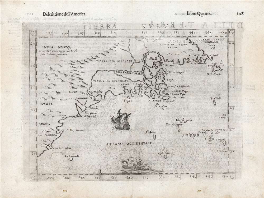
1574 Ruscelli Map of New England and the Maritimes (Norumbega)
1574 (undated) $2,000.00
1598 Ruscelli/ Rosaccio Map of the North American East Coast
TierraNueva-ruscelli-1598$900.00

Title
Tierra Nueva.
1598 (undated) 7.5 x 10.5 in (19.05 x 26.67 cm) 1 : 21000000
1598 (undated) 7.5 x 10.5 in (19.05 x 26.67 cm) 1 : 21000000
Description
This is Girolamo Ruscelli's 1561 map 'Tierra Nueva', in its amended and embellished 1598 Giuseppe Rosaccio edition. In its first issues, this represented an early and influential map of the North American coastline from South Carolina to New England and the Canadian Maritime Provinces. Even in this 1599 edition, this remains one of the earliest acquirable maps to cover the eastern coast of North America.
A Closer Look
The map spans from upper Florida northwards past Cabo de Santa Maria to Larcadia (Kitty Hawk), Angoulesme (New York Harbor), Nova Scotia, and Labrador. Rosaccio, in reissuing Ruscelli's map, adds not only the obvious decorative elements of the mountains, the sea monster and the sailing ship but also adds an array of place names not present on the earlier editions of the map. These were added in response to other maps on the market - notably Ortelius - which revealed new discoveries. The map's topography is the same as Ruscelli's 1561 iteration of the 1548 Gastaldi. The Gastaldi was limited entirely to the coast, while Ruscelli's map attempted to show a network of rivers and is among the first regional maps to illustrate mountains in the interior of North America.Discoveries and Place Names
This 1598 edition is identified by the fine sailing ship and sea monster. Closer observation reveals that new information has been added in addition to these purely decorative features. The main land mass bears a new title - India Nuova - along with a note crediting its discovery to Columbus in 1492. Many of the newly-added place names derive from Ortelius' map of America. These include the placement of New France (Nova Francia) to the west of New York Harbor, the inclusion of the territory 'Avagal' (Avacal), and the nearby 'Mocosa'. Ortelius is not the only supplemental source. The English colony of Virginia is named, possibly from the 1590 White/De Bry map. Most of the names appearing in the Canadian Maritimes derive from Ortelius, such as C. de Laborador, and C. Fredo, as well as the Atlantic island of Sept Cites. The inclusion of locations from the supposed exploration of the Zeno brothers such as the islands of Icaria and Drogeo de Francesi in the Canadian Maritimes might derive from the 1561 Zeno / Ruscelli map. In the southeast in the vicinity of South Carolina appears the Porto de St. Helena, near an unnamed settlement which may have been La Caroline. A settlement of 'S ioan' (St. John) could refer to the C. de St. John.Deviations from Ortelius
At the mouth of a 'Rio Grande' is noted a 'C. de lagus islas'. Both of these appear on the Ortelius, but on the present map they appear further south and to the west. While Ortelius associates these places with Norumbega, Rosaccio places them in a way which tantalizingly resembles Delaware Bay. Likewise the place name 'Claudia' appears here far to the west of its location on the Ortelius. Rosaccio locates the 'Terra Corte Real' amongst the puzzling network of rivers between Labrador and Nova Francia, while Ortelius' map places these north of the St. Lawrence River. Far to the north, Rosaccio includes an entirely new river and lake, 'Lago de Gusleme,' the derivation of which we have not identified.Publication History and Census
This map was engraved for the 1561 first Ruscelli edition of Claudius Ptolemy's La Geografia di Claudio Tolomeo. In 1598, this work was edited and republished by Giuseppe Rosaccio. Typographically identical editions followed but this map in the 1599 and later editions exhibits a prominent plate crack in the bottom border at 30° longitude not evident in the 1598. While only three separate examples are listed in OCLC, the map does appear on the market from time to time and the volume is reasonably well represented in institutional collections.CartographerS
Girolamo Ruscelli (1500 - 1566) was an Italian polymath, humanist, editor, and cartographer active in Venice during the early 16th century. Born in Viterbo, Ruscelli lived in Aquileia, Padua, Rome and Naples before relocating to Venice, where he spent much of his life. Cartographically, Ruscelli is best known for his important revision of Ptolemy's Geographia, which was published posthumously in 1574. Ruscelli, basing his work on Gastaldi's 1548 expansion of Ptolemy, added some 37 new "Ptolemaic" maps to his Italian translation of the Geographia. Ruscelli is also listed as the editor to such important works as Boccaccio's Decameron, Petrarch's verse, Ariosto's Orlando Furioso, and various other works. In addition to his well-known cartographic work many scholars associate Ruscelli with Alexius Pedemontanus, author of the popular De' Secreti del R. D. Alessio Piemontese. This well-known work, or "Book of Secrets" was a compilation of scientific and quasi-scientific medical recipes, household advice, and technical commentary on a range of topics that included metallurgy, alchemy, dyeing, perfume making. Ruscelli, as Alexius, founded a "Academy of Secrets," a group of noblemen and humanists dedicated to unearthing "forbidden" scientific knowledge. This was the first known experimental scientific society and was later imitated by a number of other groups throughout Europe, including the Accademia dei Secreti of Naples. More by this mapmaker...
Giacomo Gastaldi (c. 1500 - October, 1566) was an Italian astronomer, cartographer, and engineer active in the second half of the 16th century. Gastaldi (sometimes referred to as Jacopo or Iacobo) began his career as an engineer, serving the Venetian Republic in that capacity until the fourth decade of the sixteenth century. During this time he traveled extensively, building a large library relating to voyages and exploration. From about 1544 he turned his attention to mapmaking, working extensively with Gextantiovanni Battista Ramusio, Nicolo Bascarini, and Giovanbattista Pedrezano, as well as taking private commissions for, among others, Venice's Council of Ten. He is credited with the fresco maps of Asia and Africa still extant in the map room of the Doge's Palace. Gastaldi was also one of the first cartographers to embrace copper plate over woodblock engraving, marking an important development in the history of cartography. His 1548 edition of Ptolemy's Geographia was the first to be printed in a vernacular; it was the first to be printed in copperplate. As with his Swiss/German contemporary Münster, Gastaldi's work contained many maps depicting newly discovered regions for the first time, including the first map to focus on the East Coast of North America, and the first modern map of the Indian Peninsula. His works provided the source for the vast majority of the Venetian and Roman map publishers of the 1560s and 70s, and would continue to provide an outsize influence on the early maps of Ortelius, De Jode, and Mercator. Learn More...
Source
Ruscelli, G., La Geografia di Claudio Tolomeo Alessandrino…, (Venice: Heredi di Melchoir Sessa) 1599.
Beginning in 1561, Girolamo Ruscelli published this important, expanded edition of Giacomo Gastaldi's 1548 Ptolemy. Its maps, engraved in Venice by Giulio Sanuto, were in the main based directly upon those in Gastaldi's 1548 work. The maps were larger format than Gastaldi's, however, and Sanuto's engraving was far clearer and more legible than those appearing in the 1548 work. There are some important additions that distinguish Ruscell's Ptolemy from Gastaldi's. Ruscelli's work contained a map of the habitable world according to Ptolemy, which the Gastaldi lacked; also, the double-hemisphere map appearing in the Ruscelli was new and did not appear in the Gastaldi. Ruscelli's modern map of England was based on the work of George Lily, rather than the Waldseemüller-derived map appearing in the Gastaldi; the Ruscelli is the earliest generally acquirable map of England based on knowledge from someone who lived there. In a fateful innovation, Ruscelli's work included Septentrionalium partium nova tabula,the first copy of Nicolo Zeno's 1558 fraud Carta da Navegar, which introduced a novel mapping of the north parts of the world, including the phantom islands of Frisland, Icaria, Drogeo and Estotiland. Had Ruscelli not copied the Zeno - which had a narrow, brief publication - this preposterous geography would have probably not taken hold. Its inclusion in Ruscelli's beautiful, authoritative and popular work would lead to the adoption of the Zeno map by Mercator, Ortelius, Plancius and their successors, baffling scholars for centuries. Ruscelli's Ptolemy had a long publication history, cementing the influence of the work. It appeared both in Italian and Latin editions, all printed in Venice, throughout the latter 16th century:
- 1561 La Geographia di Claudio Tolomeo Alessandrino, Italian. Venice, Vincenzo Valgrisi.
- 1562 Geographia Cl. Ptolemaei Alexandrini, Latin. Venice, Vincenzo Valgrisi.
- 1564 La Geographia di Claudio Tolomeo Alessandrino, Italian. Venice, Giordano Ziletti.
- 1564 Geographia Cl. Ptolemaei Alexandrini, Latin. Venice, Giordano Ziletti.
- 1574 La Geographia di Claudio Tolomeo Alessandrino, Italian. Venice, Giordano Ziletti.
- 1598 Geographia di Claudio Tolomeo Alessandrino, Italian. Venice, heirs of Melchoir Sessa.
- 1599 Geographia di Claudio Tolomeo Alessandrino, Italian. Venice, heirs of Melchoir Sessa.
Condition
Excellent. Text on verso with minimal showthrough. Faint offsetting, overall a bold sharp strike.
References
Burden, P., The Mapping of North America, #30. Kershaw, K. A., Early Printed Maps of Canada, pp. 22-23.