1897 Garcia Cubas Map of Tlaxcala
Tlaxcala-garciacubas-1897$500.00
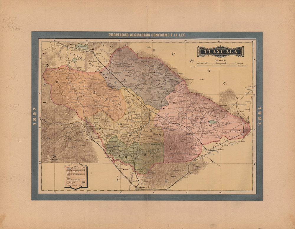

Title
Tlaxcala.
1897 (dated) 15.25 x 21 in (38.735 x 53.34 cm) 1 : 230000
1897 (dated) 15.25 x 21 in (38.735 x 53.34 cm) 1 : 230000
Description
A lovely map of Tlaxcala, Mexico, published in the 1897 edition of Atlas Geográfico de los Estados Unidos Mexicanos. It depicts the state in the midst of an infrastructure drive that included new roads and railways.
A Closer Look
The territory of Tlaxcala, Mexico's smallest state by area, also one of its most densely populated, is displayed in detail. The state's namesake city appears near center, towards bottom, and its districts are distinguished by color shading (the internal administrative divisions of the state today differ considerably from what is seen here). Aside from cities and towns, ranchos and haciendas are indicated, as well as roads, railroads, waterways, and mountains (some with elevations noted). The large number of railroads is notable, in part a result of the state's proximity to Mexico City, and in part due to the developmentalist policies championed by the state's governor Próspero Cahuantzi (1834 - 1915).'El Prosperato'
Historically known for its autonomy and deep connection with indigenous culture, at the time this map was published, Tlaxcala's governor was Próspero Cahuantzi, one of the few leaders in 19th-century Mexico of indigenous heritage. Governing the state for more than 25 years, Cahuantzi was an ally of President Porfirio Díaz, and shared his combination of ambition, heavy-handedness, and affinity for industrial development. Like Diaz's 'Porfiriato,' Cahuantzi was such a towering figure that his name came to be associated with the time period at which he ruled, at least in Tlaxcala. He only lost power due to the Mexican Revolution in 1911; afterwards, he attempted a political comeback, but was arrested by the forces of Francisco 'Pancho' Villa and died in prison.Publication History and Census
This map was published in Mexico City in 1897 by Vega y Cie. It is based on the 1887 work of Antonio García Cubas, and was updated with additional border work for the 1897 issue of the Atlas Geográfico de los Estados Unidos Mexicanos. The atlas is represented in several institutional collections but is extremely scarce on the market. The individual maps, likewise, are scarce to the market.Cartographer
Antonio Garcia y Cubas (July 24, 1832 - February 9, 1912) was a Mexican cartographer, writer, engineer, and geographer active in Mexico City in the second half of the 19th and the early 20th centuries. He is considered Mexico's first great geographer. Garcia y Cubas was born in Mexico City. He was orphaned at birth and was raised by is aunt. When he turned 18, he enrolled in the Dirección General de Industria, a government sponsored technical school. There he studied engineering and geography, which he further pursued at the Colegio de San Gregorio, Colegio de Ingenieros. He graduated with honors in geography and from 1856, became a member of the Sociedad Mexicana de Geografía y Estadística. His geographical work earned him the Order of Guadalupe, a Mexican second empire honorific, directly from the Emperor Maximillian. He published several atlases, including his important Atlas Geográfico, Estadístico e Histórico de la República Mexicana, and multiple decorative chromolithograph Atlas Pintoresco e Históricos covering Mexico, Cuba, Spain, and elsewhere. Today his work is scarce and highly desirable. More by this mapmaker...
Source
García Cubas, Antonio, Atlas Geográfico de los Estados Unidos Mexicanos, (Mexico City: Vega) 1897.
Atlas Geográfico de los Estados Unidos Mexicanos is a grand-format folio atlas of Mexico. It is based largely upon the Atlas Geográfico y Estadístico de los Estados Unidos Mexicanos published in 1887 by Antonio García Cubas and Debray. The present atlas incorporates the same maps, but adds a dramatic silver and gold border, which obscures the 1886 García Cubas imprint. It was issued during Porfirio Díaz's third term as president of Mexico - a period marked by rapid expansion of infrastructure and industry, including railroads, mines, bridges, roads, and broad scale electrification and waterworks. The atlases title page in this 1897 edition, celebrates Diaz with a large portrait and dedication. We have identified at least two editions of this atlas, both bearing the 1897 date: one by Cadena y Cie, features a red title page, another by Vega y Cie, featuring a blue title page. All 1897 editions we have identified have the silver borders, but these seem to be overprinted to cover an earlier gold border, with unidentifiable text and dating behind. We have been unable to find any examples with only the gold border. The atlases in general are showpieces of Mexican lithography in the golden age of the Porfiriato.
Condition
Good. Verso repairs to centerfold separations. Closed margin tears measuring 1 and 3 inches respectively professionally repaired on verso. Wide margins.
References
Rumsey 5758.027 (1886 edition).