This item has been sold, but you can get on the Waitlist to be notified if another example becomes available, or purchase a digital scan.
1880 Hitchcock Map of the White Mountains, New Hampshire
TopoWhiteMountains-hitchcock-1880$187.50

Title
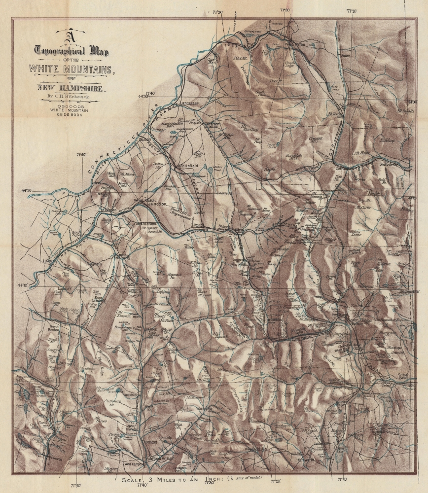
A Topographical Map of the White Mountains, of New Hampshire.
1880 (undated) 21.5 x 18.25 in (54.61 x 46.355 cm) 1 : 190000
1880 (undated) 21.5 x 18.25 in (54.61 x 46.355 cm) 1 : 190000
Description
This is striking c. 1880 Charles H. Hitchcock chromolithograph topographical map of the White Mountains, New Hampshire. This map emerged as the White Mountains were beginning to see widespread railroad connections, making the stunning forested region accessible to urbanites in search of a reprived from stultifying city life.
A Closer Look
Depicting from West Milan south to West Campton and from Lisbon east to Chatham, townships throughout the region are marked by dotted and dashed lines. Hitchcock illustrates the White Mountains in detail, including its towns, lakes, and railroad lines. Towns are identified by bold type, while mountains, hills, rivers, falls, brooks, and ponds are labeled in italics. The Boston, Concord, and Montreal Railroad's route appears, along with that of the Grand Trunk Railroad.Chromolithography
Chromolithography, sometimes called oleography, is a color lithographic technique developed in the mid-19th century. The process uses multiple lithographic stones, one for each color, to yield a rich composite effect. Generally, a chromolithograph begins with a black basecoat upon which subsequent colors are layered. Some chromolithographs used 30 or more separate lithographic stones to achieve the desired effect. Chromolithograph color can be blended for even more dramatic results. The process became extremely popular in the late 19th and early 20th centuries when it emerged as the dominant method of color printing. The vivid color potential of chromolithography made it exceptionally effective for advertising and propaganda.Publication History and Census
This map was created by Charles H. Hitchcock and published in James Osgood's c. 1880 The White Mountains: Handbook for Travelers. We note two examples of the separate map in OCLC: Leventhal Map Center at the Boston Public Library and the Beinecke Library at Yale University. The map rarely appears on the private market.Cartographer
Charles Henry Hitchcock (August 23, 1836-November 5, 1919) was an American geologist. He was born in Amherst, Massachusetts to Edward Hitchcock (1793-1864), himself a professor of geology and natural theology at Amherst College, and Orra White Hitchcock, who illustrated much of his father's work. He was assistant state geologist of Vermont (1857-61), state geologist of Maine (1861-2), and New Hampshire state geologist (1868-78), during which latter tenure he produced the first set of detailed maps of the geology of New Hampshire. He taught at Dartmouth College in from 1868 to1908, holding the Hall Professorship of Geology and Mineralogy. More by this mapmaker...
Condition
Very good. Light toning and soiling.
References
Norman B. Leventhal Map and Education Center at the Boston Public Library Call # G3742.W52 1870 .H5. Beinecke Library at Yale University Call # 762 W588 1880.