1725 Renier and Josue Ottens Map of Transylvania
Transylvania-ottens-1725$1,600.00

Title
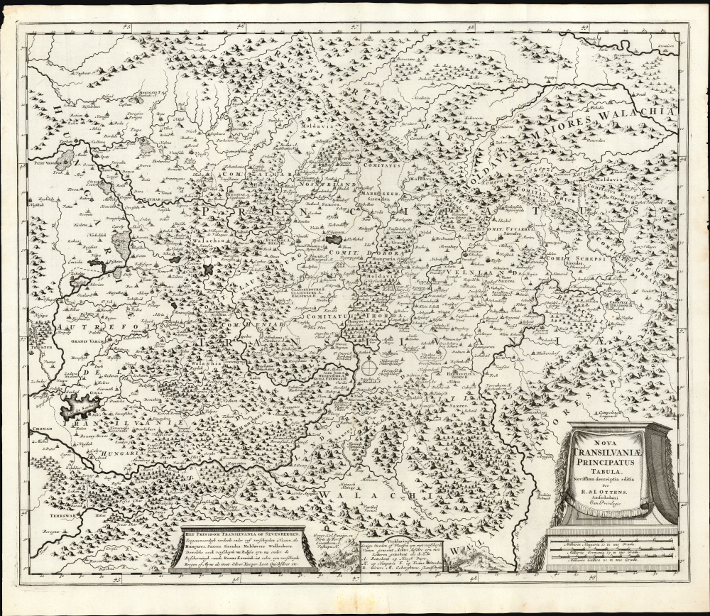
Nova Transilvaniae Principatus Tabula. Novissima descriptia editia Per R. et I. Ottens. Amstelodami Cum Priviligeo.
1725 (undated) 19.5 x 23.5 in (49.53 x 59.69 cm) 1 : 730000
1725 (undated) 19.5 x 23.5 in (49.53 x 59.69 cm) 1 : 730000
Description
This is Josue and Renier Ottens / Danckerts c. 1725 map of Transylvania. The map was published in the wake of the Great Turkish War (1683 - 1699) during a period of German migration into Transylvania and the Banat.
A Closer Look
The map spans from the eastern frontier of Hungary, at the limit of the Kraszna and Eger Rivers, to the Olt River watershed in central Romania. Its northern regions now comprise western Ukraine. The southern border includes Timisoara and part of the Banat of Temeswar. The region's mountainous, forested terrain is evoked pictorially. At the bottom right is a garlanded, plinth-style cartouche including the title, imprint, and scales. Two subordinate, elegant cartouches at the bottom include descriptive and explanatory notations. Between these, armies are illustrated as if pouring into the map from the south: an allusion to the region's status as a frontier between Hungary and the Ottoman Empire.Historical Context
Transylvania at the end of the 17th century was politically complicated, as the mapmaker notes at bottom:The principality of Transylvania, or Sevenbergen, is currently divided among five different nations: Hungarians, Saxons, Sircules, Moldavians, and Wallachians. These, too, of various religions, are now under the protection of the Roman Catholic Church in its various provinces…Many cities on the map are given multiple names, with a letter key identifying the usage as German, Hungarian, or (interestingly) French. The prominent inclusion of Montgats, now Mukachevo in the Ukraine, is suggestive. It is among the small minority of places with a French name. It has variously been considered part of Transylvania and Hungary, regions which, for the most part, had not fallen within the French sphere of influence. Mukachevo was, however, the starting point of several Transylvanian independence movements: the 1678 revolt of Emeric Thököly de Késmárk and the 1703 - 1711 war of independence under Francis II Rákóczi - the seeds of which had been sown in the 1690s. France, wishing to confound their Habsburg rivals, supported both rebellions - perhaps the reason for the French placename here.
Publication History and Census
This plate was engraved around 1696 by Cornelis Danckerts III for inclusion in his family's atlases. The plate was acquired by the Ottens firm, which changed the imprint and continued the publication of the map with no other changes. It is rare; we see only five listings in institutional collections, and we do not see it in auction records after 2004.CartographerS
Ottens (fl. c. 1680 - 1785) was a prominent Amsterdam map publishing family active for nearly 100 years. Joachim Ottens (1663 - 1719) was born in Amsterdam to a family of seafarers and educated in Amsterdam's Evangelical Lutheran community. He likely learned copperplate engraving under Frederick de Wit (1629 - 1706), for whom he worked until about 1710. In 1710, he was admitted to the Sint-Lucasgilde (Guild of St. Luke) and, in 1711, Joachim founded his own firm. Although Joachim died only a few years later, in 1719, his widow continued the business, either publishing as either 'I. Ottens', 'Ottens', or 'In de Wereldcaert' [In the World Map]. In 1726, Joachim Otten's sons, Renier (1698 - 1750) and Joshua (1698 - 1750), established a partnership and generally published as 'R. and I. Ottens'. Although they ran separate shops, on Nieuwendijk and Kalverstraat, they worked jointly as a singular business until Renier's death in 1750, at which point Joshua assumed full control. After Joshua's death in 1765, his widow continued the firm with their son, Renier II, changing the imprint to 'Joshua and Reinier Ottens.' Joshua's widow, Johanna de Lindt, held an auction sale of their engraved plates in 1784. Ottens' work stands out in that all of their maps were separate issues, though often found compiled into special, made-to-order multi-volume composite Atlas factice works, such as the Atlas. Some examples of the Atlas include over 800 separately issued maps. Because they were not uniformly issued in standard atlases, Ottens maps are often of the utmost rarity and are notable for their exceptionally rich engraving. More by this mapmaker...
The Danckerts family (fl. 1628 - 1717) were a Dutch engraving and cartographic publishing firm active in Amsterdam during the latter half of the 17th and early 18th centuries. The firm was founded by Cornelis Dankerts II (1603-1656) and his brother Dancker Danckerts (1614-16?). Cornelius and Dancker published few maps, but did pass the business on to Cornelius' son Justus Danckerts (1635 - 1701) and grandsons Theodorus Danckerts (1663-1727) and Cornelius Danckerts III (1664-1717). The firm was most active in this period between 1680 and 1700 when a number of atlases and maps appeared bearing either the Justus Danckerts or Theodorus Danckerts imprint. At the time, it was in vogue in Amsterdam to leave maps undated, which makes Danckerts maps particularly difficult to ascribe. Similarly, there is a considerable corpus of maps signed as Cornelius Danckerts. When dated we can correctly attribute these to either Cornelius II or Cornelius III, though, typically, most are undated and consequently difficult to attach to the correct Danckerts family member. The Danckerts family is well known for its highly detailed and graphic engraving style. In addition to numerous atlas maps, they also produced a number of spectacular Dutch wall maps. In the early 18th century, the Danckerts map plates were purchased by R. and J. Ottens, who reprinted many of them under their own imprint. (Ref: Keuning, J., "Cornelis Danckerts and his "Niew Aerdsh Pleyn"", Imago Mundi, Vol. 12 (1955), pp. 136-139.) Learn More...
Condition
Excellent.
References
OCLC 1062032013. Koeman, C., Atlantes Neerlandici, volume III, p.86.