
1937 Testoni Map of Lakes Maggiore, Lugano, and Como, Switzerland, Italy

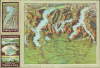
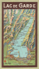
Excursions Carte des Trois Lacs and Lac de Garde.
Gorgeous alpine glacial lakes.
$250.00
Choose a Collection:
- Digital Map Information
- Suitable for large format printing
- DPI: 600
- File Size: 13.61 MB
- File Type: ZIP / TIFF
- ICC color profile embedded
- Delivered instantly via download link
This Item
Enquire
Gorgeous alpine glacial lakes.
A charming 1937 folding relief map of the Italian lake region, including Lake Maggiore, Lake Lugano, and Lake Como. It was produced by Arti Grafiche Testoni and Co., a commercial printer of such foldout maps and brochures catering to tourists, based in Milan and Como.A Closer Look
This view is oriented towards the north with Milan in the foreground and the Alps in the background. The map reaches just as far north as the Swiss town of Bellinzona. The three glacial lakes referred to in the title command the eye visually, but the lower part of the map amply details the roadways connecting the Lake Region with the cities of Milan and Novara. In particular, the new Autostrade connecting Milan with Gallarate, Varese, Como, and Sesto Calende is printed in red. (These routes are now the A8 and A). Aside from lakes and rivers, cities, towns, major roads, minor roads, and mountains with their heights in meters are illustrated. The front cover panel is decorated with three views taken from the lakes featured in the title. The back cover, meanwhile, displays a map of the Lago de Garda.It is notable that the title of the brochure is in French, implying that it was intended for French-speaking tourists from other parts of Switzerland or France.
Publication History and Census
This map was printed by Arti Grafiche Testoni and Co. It is dated 1937; we are aware of other separate editions of 1925, 1934, 1935, and a 1950s edition included in a booklet.Condition
Very good. Some wear along fold lines, mends at few junctures of folds.
References
OCLC 809069634 (1934).