
This item below is out of stock, but another example (left) is available. To view the available item, click "Details."
Details
1851 Black Map of Turkey in Asia
1851 (undated) $125.00
1840 Black Map of Turkey in Asia
TurkeyAsia-black-1840$62.50

Title
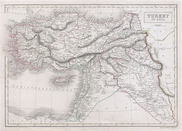
Turkey in Asia.
1840 (undated) 11.5 x 16 in (29.21 x 40.64 cm)
1840 (undated) 11.5 x 16 in (29.21 x 40.64 cm)
Description
A fine example of Adam and Charles Black's 1840 map of Turkey in Asia. The map covers from the Black Sea to Arabia, inclusive Cyprus. Centered on the Holy land (Palestine / Israel), the map covers the modern day countries of Turkey, Cyprus, Iraq, Israel, Palestine, Jordan, Lebanon, and Syria. The map to the last days of the Ottoman empire, whose influence, though rapidly declining, still dominated much of the Middle east. This map was engraved by S. Hall for issue in the 1840 edition of Black's General Atlas.
Cartographer
Charles and Adam Black (fl. 1807 - present) were map and book publishers based in Edinburgh. Charles and his uncle, Adam, both of Edinburgh, Scotland, founded their publishing firm in 1807. They published a series of maps and atlases throughout the 19th century. In addition to an array of atlases, the Black firm is known for their editions of the Encyclopedia Britannica (1817 - 1826) and the first publishing of Sir Walter Scott's novels in 1854. In 1889 the A. & C. Black publishing house moved to London where it remains in operation to this day. More by this mapmaker...
Source
Hall, Sydney, Black's General Atlas: A series of Fifty-Four Maps from the Latest and Most Authentic Sources, Engraved on Steel, In the First Style of the Art, (Edinburgh: Adam and Charles Black) 1840.
Condition
Very good. Blank on verso. Original platemark visible.
References
Rumsey 2305.041 (1854 edition). Philips (atlases) 4334.