This item has been sold, but you can get on the Waitlist to be notified if another example becomes available, or purchase a digital scan.
1762 Jonas Hanway Map of the Caspian Sea and the Aral Sea
Turkmenistan-gibson-1753$375.00

Title
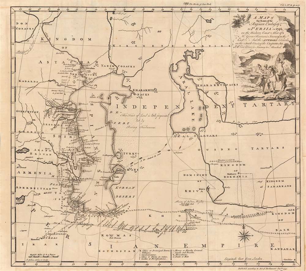
A Map of the Routs of the Russian Embassy to Persia in 1746, also of Mr. George Thompson's journey on the East and the author's travels on the South coast of the Caspian sea, with Mr. Van Mierop's Journey to Mesched.
1753 (dated) 18.25 x 19.75 in (46.355 x 50.165 cm) 1 : 4771290
1753 (dated) 18.25 x 19.75 in (46.355 x 50.165 cm) 1 : 4771290
Description
This is an example of John Gibson's rare map of the Caspian region, engraved in 1753 to accompany Jonas Hanway's account of his journey from Russia to Persia. It represents one of the first and best detailed, maps of the region based on firsthand exploration. The map combines details of Hanway's own journey with reconnaissance from the 1740 journey of British merchant George Thompson, that of Martin Kyck van Mierop, a cloth merchant who traveled the region in 1746, and an abortive 1746 Russian embassy to Persia on behalf of the Tsarina Elizabeth Petrovna. The map shows the area around the Caspian Sea and northern Iran, as well as parts of modern-day Turkmenistan and Uzbekistan.
Iranian Borders after Nadir Shah
Thus, the map shows the northern frontier of Iran as it was known to European travelers in the 1740s, up to and following the death of Nader Shah Afshar (1688 - 1747). One of the most powerful rulers in Iranian History, Nader Shah was assassinated in Quchan in the province of Khorasan (northwest of Mashhad, here spelled Mesched). Quchan is not named, but labeled 'Here Nadir Shah was kill'd.' As a result of Nader Shah's death, the empire shattered and the Uzbek Dominion of Khiva and the Kingdom of Bokhara regained their independence. The map further includes excellent detail for the kingdoms of Astrakhan, Georgia, Armenia and Azerbaijan on the western shore of the Caspian.Traveler's Tracks
The cartographer includes several explorers' tracks, in order to support Hanway's text. These include Thompson's voyage along the west coast of the Aral Sea to the Dominion of Khiva; the 1742 van Mierop journey from Casbin to Mashhad; and the 1746 Russian embassy from Astrakhan south along the west coast of the Caspian via Derbend, Baku, and Reshd. Hanway's own journey, taken from Astrakhan to Astrabad by water, is also marked.The Aral Sea
This is one of the first maps to detail, with any precision, the Aral Sea: then a massive endorheic lake, now an infamous desert. The bed of the semi-legendary River Oxus, once thought to connect the Caspian with the Aral, is also shown. The map's detail extends to cities, towns, caravansaries, fortifications and even tent-cities. Marshy ground, hills and mountains are shown pictorially. In addition to the mortuary note regarding Nadir Shah, the map includes other descriptive detail: 'This Tract of Land is little frequented but by Roving Turkumans' and, 'Mountains in which the Persians pretend are Gold Mines.'Elegantly Presented
Gibson's map is beautifully engraved and embellished with a fine compass rose. It includes an attractive pictorial cartouche, featuring a mountainous scene with Turkic soldiers on foot and horseback, a slain soldier with a broken spear on the ground before them. Battle can just be seen in the background.Publication History and Census
The map was engraved by John Gibson in 1753 for inclusion in Jonas Hanway's An Historical Account of the British Trade over the Caspian Sea. We are aware of three editions of the work; this example appeared in the third. It is distinguishable from the early editions only by the typeset pagination in the upper border. We see eight examples of the complete work in institutional collections. We see only one example of this map catalogued in OCLC, in the 1753 issue, at the Bibliotheque National de France.CartographerS
Jonas Hanway (August 12, 1712 - September 5, 1786), was an English philanthropist, traveller, and writer. He was apprenticed in 1729 to a merchant in Lisbon, but in 1743 he became partner to merchant and member of the British Russia Company Robert Dingley (1710 - 1780) who was based in St. Petersburg. This led to the travels in Russia, Central Asia, and Persia which would inform Hanway's (copious) writing on the topic of British trade in the Caspian Sea, which would earn him the attentions of scholar Charles Wilson who hailed him 'one of the most indefatigable and splendid bores of English history.' On his return to London his narrative brought him some fame and success, and thereafter he remained in the city devoted to good causes and good citizenship. He founded The Marine Society in 1756 (a charity supporting inland youths wishing to go to sea.) He was instrumental in the aid of various hospitals; arranged improvements in Londons's birth registration system; and in 1762 he was appointed a commissioner for victualling the navy. Hanway was an eccentric and a gadfly. He protested, voluminously, the English practice of tea drinking, both on the grounds of its effect on the health and on the balance of foreign trade. He was the first male Londoner to carry an umbrella. This shocking move drew the opprobrium of fellow Londoners who objected to the effeminate, French contraption, and the ire of hansom cab drivers who quite correctly identified the invention as a threat to their trade (rainstorms caused Londoners to flock to hansom cabs as a sheltered means of transport.) He died unmarried. A monument to his memory stands in Westminster Abbey, praising his works of charity. It discusses neither umbrellas nor tea. More by this mapmaker...
John Gibson (1724 – 1773) was an English map engraver active in London at the end of the 18th century. Gibson was the son of a locksmith. In 1739 he apprenticed to John Blundell as a stationer of Grub Street. Gibson proved a fine engraver and was much in demand by London map publishers. During his career he produced thousands of maps and was admired as a skilled engraver and sculptor. Among others, he engraved for Emanuel Bowen, Robert Sayer, Jean Palairet, John Rocque, Andrew Dury, and Benjamin Martin. His best known work was prepared in conjunction with Gentleman's Magazine. Gibson, sadly, was not as astute in his fiscal affairs as with the engravers pen and consequently spent much of his life consigned to debtor's prison. Learn More...
Source
Hanway, Jonas, An Historical Account of the British Trade over the Caspian Sea with the Author's Journal of Travels from England through Russia into Persia; and back through Russia, Germany and Holland, (London) 3rd Edition, 1762.
Condition
Very good. Margin reinstated at insertion point, not affecting printed image.
References
OCLC 921702729 (1753).