This item has been sold, but you can get on the Waitlist to be notified if another example becomes available, or purchase a digital scan.
1572 Ortelius Map of the World (first plate, first state)
TypusOrbisTerrarum-ortelius-1570-2$4,250.00

Title
Typus Orbis Terrarum.
1570 (undated) 13.25 x 19.5 in (33.655 x 49.53 cm) 1 : 80000000
1570 (undated) 13.25 x 19.5 in (33.655 x 49.53 cm) 1 : 80000000
Description
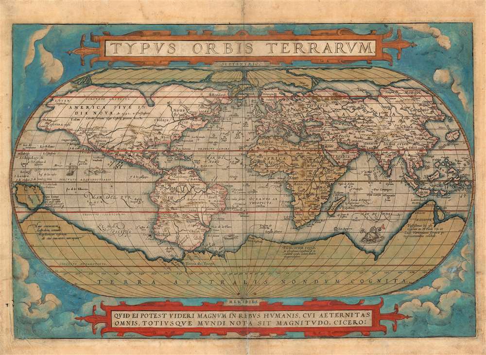
A superbly-colored example of Abraham Ortelius' iconic 1570 map of the world, here in a 1572 edition, still the first state of the first plate. This map is the first map of the world to appear in a standard atlas and is thus of fundamental importance to the history of cartography. It was one of the most widely-seen, and most influential printed maps of the world produced in the sixteenth century.
The Sources
Ortelius' map is centered on the Atlantic Ocean, and shows the entire globe in an oval projection, extending to the poles. While the convention of an oval projection is from earlier maps by Apianus and Bordone, the cartography is derived from the maps of Gerard Mercator (1569), Gastaldi (1561), and Gutierrez. Ortelius, a consummate compiler and synthesizer of data, also consulted earlier maps by such luminaries as Frisius, Fries, and Orontius Fine.North America
Ortelius' depiction of the continent - still mostly unexplored by Europeans - follows the work and forms laid down by Gerard Mercator in 1569. Beyond known colonial centers in central Mexico and the West Indies, the cartography is largely speculative. The eastern seaboard juts noticeably eastward - a product of inaccurate measurements of longitudes and magnetic variation. Several rivers appear on the Gulf Coast, although Hernando de Soto and Moscoso's 1540 discovery of the Mississippi is not among them. Place names north of Mexico generally correspond to American Indian centers discovered by De Soto (east of Texas) and Coronado (west of Texas). In the northeast, the voyages of Verrazano and Cartier are much in evidence, with the St. Lawrence being clearly represented. The mythical kingdom of Norumbega is identified along the Atlantic coast, roughly in the vicinity of the Penobscot River. Of the Great Lakes, there is as yet no trace. Some have suggested that the inlet in the northern Polar Regions, which is derived from Mercator's Lake Conibas, may suggest some knowledge of the great lakes long before their discovery - but this is the purest speculation. The Chesapeake Bay has yet to be discovered. The Pacific Northwest is almost entirely speculative, with the apocryphal kingdoms of Anian (derived from Marco Polo's writings), Quivira (a kingdom of gold associated with Coronado expedition and located near modern day Kansas, but for some reason here relocated to the west coast), and Tolm (again derived from Polo). The curious inclusion of Polo's references in maps of North America underscores the fact that even in the late 16th century, European cartographers remained uncertain regarding the relationship between Asia and North America.South America
South America is most notable for the large bulge that appears on the western coast in the vicinity of modern day Chile. This anomaly appeared in the earliest editions of several Ortelius maps and was corrected in the 1585 second state of this map. Ortelius derived the error from Mercator, who may have had difficulty reconciling conflicting reports from Spanish navigators. At the very tip of South America the Strait of Magellan gives way not to Tierra del Fuego but to the sprawling apocryphal continent of Terra Australis - see below. Further north we can clearly discern the Rio de la Plata and of course the Amazon River - which was tentatively known from the ill-fated Orellana Expedition. Several known centers are mapped including Lima, Quito, Cusco, and Caracas, among others.Terre Australis
The southern Polar Regions are dominated by the vast apocryphal continent of Terra Australis. Terra Australis was a long speculated upon landmass supposedly situated in the southern hemisphere. The theoretical basis for the continent dates to the writings of Aristotle, who taught that the globe must be in balance - so as the Americas counterbalanced Europe and Africa, another undiscovered continent must counterbalance Asia.Australia and the Pacific
While Ortelius' map pre-dates the official discovery of Australia in 1606 by Dutchman Willem Janszoon, a large promontory extending northwards from Terra Australis is highly suggestive of the western coast of the southern continent. The lands of Maletur and Beach (from Polo) are noted along the coast. Most likely Mercator extracted information about Australia from the Dieppe school maps, which were believed to have been derived from secret, now lost, Portuguese maps. A small island just west of the Proto-Australian promontory is identified as Java Minor. Ortelius, working from Mercator, extracted the idea of Java Minor from the cosmographic speculations Marco Polo. Apparently, a scribal error in Book III of Polo's travels substituted Java for Champa (Vietnam), thus locating Java Minor (in fact Sumatra) well into the latitudes of Terra Australis. Attempting to rectify the inconsistencies, Mercator thus added the island of Java Minor to the proto-Australian promontory.Asia
Asia offers much of interest. The Black Sea is oriented to the east-west, a typical error of the period. Japan is mapped as a globular mass with Miaco (Mecao), clearly identified. There is no sign of Korea. Of the Great Wall there is no mention. The Spice Islands appear more accurately than on earlier works. Sumatra is recognizable but Java takes on a bulbous form. Borneo has been elongated and the whole has been absorbed into the Philippine Islands, some of which are recognizable, especially Mindanao.Africa
The continent of Africa shows a well-understood coastline, and a largely imaginary interior typical to the period. It includes the two major river systems, the Nile and the Niger, dominating the continent. The Nile here roughly follows the Ptolemaic model and extends well into southern Africa.Antilla - the Seven Cities
While there are many curious islands scattered throughout, most associated with questionable reports from little-known navigators, two stand out. Situated due east of Florida a tiny island is identified as 'Sept Citez,' but better known as Antilla. It was said that when the Moors invaded Porto in the early 8th century, the city's seven bishops took all of their wealth and fled to sea. They landed on an island in the Atlantic called 'Antilla.' There, each of the seven bishops established a city. The island of Antilla actually appears on many early portolan charts of the Atlantic. It is typically a rectangular island, usually but not always set on a north south axis, with seven deep bays, each of which holds a magnificent city.St. Brenden's Island
Another island of interest, labeled 'Y de S.Bo,' appears just northeast of South America. Better known as St. Brendan's Island, 'Y de S.Bo' appears in texts as early as the 9th century. According to the legend, St. Brenden was and Irish monk who, along with his confederates, sailed westward into the Atlantic in the hopes of evangelizing to undiscovered island peoples. Some claim that Brenden made it all the way to Newfoundland in the 6th century, on the way discovering his namesake island. Traditionally the island is located to the west of the Canaries. Some narratives refer to it as 'Eighth Canary Island,' and note that it appears only to the Blessed, earning it another name, 'The Isle of the Blessed.'Cicero
Along the bottom of the map there is a quote by Cicero, in translation, 'Who can consider human affairs to be great, when he comprehends the eternity and vastness of the entire world?.'Publication History and Census
This map was engraved by Franz Hogenberg for inclusion in the first edition of Ortelius' Theatrum; subsequent plates lack the Hogenberg imprint, and their engraver may not have been the same. This first plate remained in use for the first sixteen editions of the atlas, exhibiting increasing evidence of damage and repair as time went on. Van den Broecke assigns the second state of this plate to the 1574 Latin edition; the cracks which bedeviled the plate would not appear until later. The typesetting on the verso of this example corresponds to the 1572-73 German language edition of the Theatrum, well before those changes. In 1587, the plate was entirely replaced with a new engraving, with still another appearing two years later. Van de Broecke estimates that perhaps 150 examples were printed of the 1572-3 German edition. About twenty-five of this edition are catalogued in institutional collections. Three examples of this separate map are catalogued in this specific edition, although in its many printings it is well represented institutionally.CartographerS
Abraham Ortelius (April 14, 1527 - June 28, 1598) also known as Ortels, was a cartographer, geographer, and cosmographer of Brabant, active in Antwerp. He was the creator of the first modern atlas, Theatrum Orbis Terrarum and is a seminal figure in the history of cartography. Along with Gerard Mercator and Gemma Frisius, he was a founder of the Netherlandish school of cartography. His connections with Spain - culminating in his 1575 appointment as Royal Cartographer to King Phillip II of Spain - gave him unmatched access to Spanish geographical knowledge during a crucial period of the Age of Discovery. Ortelius was born in 1527 in Antwerp. In 1547 he entered the Antwerp Guild of Saint Luke as an illuminator of maps. He began trading in books, prints, and maps, traveling regularly to the Frankfurt book and print fair, where in 1554 he met Mercator. He accompanied Mercator on journeys throughout France in 1560 and it was at this time, under Mercator's influence, that he appears to have chosen his career as a scientific geographer. His first published geographic work appeared in 1564, an eight-sheet cordiform world map. A handful of other maps preceded the 1570 publication of the first edition of the Theatrum Orbis Terrarum, which would prove to be his life work. Appearing with but 53 maps in its first edition, Ortelius' work expanded with new maps added regularly. By 1592, it had 134 maps. Many of Ortelius' maps remained the standard for nearly a century. He traveled extensively, but his genius was as a compiler, locating the best informed maps on which to base his own. His contacts throughout Europe and extending even (via the Portuguese) to the Far East were formidable. Moreover, many of his maps were based on his own scholarship, particularly his historical works. His theories of geography were particularly ahead of his time with respect to the notion of continental drift, the possibility of which he mused on as early as 1596, and which would be proven correct centuries later.
In a sense his greatest achievement was his successful navigation of the religious and political violence endemic to his city throughout his adult life: The Dutch Revolt, or Eighty Years' War (1568 - 1648), fully embroiled Antwerp. Although outwardly and officially recognized as Catholic (Arias Montanus vouched for Ortelius' Catholic orthodoxy prior to his appointment as Royal Geographer), Ortelius was able to separate himself from the religious furor which characterized the war in the low countries. Ortelius showed a glimpse of himself in a letter to a friend, regarding humanist Justus Lipsius: 'I do not know whether he is an adherent of the Pope or a Calvinist, but if he has ears to hear, he will neither be one nor the other, for sins are committed on both sides'. Ortelius' own explorations of Biblical history in his maps, and the Christogram contained in his own motto, suggest him to be a religious man, but his abjuration of political religious authorities mark him as an individualist. His tombstone at St Michael's Præmonstratensian Abbey in Antwerp bears the inscription, Quietis cultor sine lite, uxore, prole. ('served quietly, without accusation, wife, and offspring.') More by this mapmaker...
Franz Hogenberg (1535 - 1590), often called 'Master Franz,' was a Flemish engraver active in the late 16th century. Hogenberg was born in Mechelen, the son of Nicolas Hogenberg, where he trained under the cartographer H. Terbruggen. He later relocated to Antwerp where he achieved success as an engraver, working with Abraham Ortelius, Hieronymus Cock, and others. In 1568, his name appeared on the list of those banned from the Netherlands by the Duke of Alva, forcing his family to flee to London. There he engraved for Christopher Saxon's Atlas of England and Wales. By 1570 he emigrated to Germany settling in Cologne. In Cologne he married his second wife, Agnes Lomar, with whom he had six children. In 1579 the couple were briefly imprisoned for holding illicit secret religious meetings, but were released in short order. Along with German cleric George Braun (1541 – March 10, 1622), Hogenberg issued the highly influential city atlas Civitates Orbis Terrarum. The six volume work, with some 546 views, was published between 1572 and 1617 and intended a companion to Abraham Ortelius' Thatrum Orbis Terrarum - thus certain obvious stylistic similarities. In compiling the Civitates Hogenberg took on the role of engraver while most of the editing was left to Georg Braun. Hogenberg died in Cologne, Germany, before the Civitates was completed. After his death, Hogenberg's work was continued by his son, Abraham Hogenberg, who, under the direction of Agnes, his mother, took over his father's enterprise at just 20. Learn More...
Source
Ortelius, A., Theatrum Orbis Terrarum, (Antwerp) German Edition. 1572-3.
Abraham Ortelius' magnum opus, Theatrum Orbis Terrarum, was the world's first regularly produced atlas, which 'set the standards for later atlases . . . It was the first undertaking of its kind to reduce the best available maps to an uniform format.' (Koeman) A modestly-sized work of fifty-three maps in its first edition of May 1570, it was an immediate success: there were three further editions that year, and the work remained in print for a total of 32 editions, the last of which was 1641, well after its author's 1598 death. Ortelius added to his atlas constantly, and by 1595 the Theatrum contained 147 maps. Ortelius is renowned generally as an editor, and indeed much of the Theatrum is compiled from a variety of sources: in such cases, Ortelius was scrupulous in naming his sources. But Ortelius was also a mapmaker in his own right: many of his maps are a distillation of various sources into his own work, and there were many maps - particularly in his atlas of Biblical and ancient history Parergon - which were entirely Ortelius' work. In his role as an editor, Ortelius followed in the footsteps of Munster, whose Cosmographia was, until Ortelius, the best window on the world for the curious European reader. In terms of the artistry of his maps, Ortelius oversaw the first great flourishing of copperplate engraving in the service of cartography to occur in Northern Europe. Ortelius' work provided the model for the atlases of Mercator, Hondius, Blaeu and all their progeny in the 17th century - many of whom were to produce faithful editions of Ortelius' maps in their own productions.
Condition
Very good. Two small, expert surface mends in cloud areas. reinforcement along original centerfold. Lower centerfold reinforced. Latin text on verso. Original hand color with a beautiful patina.
References
OCLC 846794908. Shirley, Rodney W., The Mapping of the World: Early Printed World Maps 1472-1700, 122. van den Broecke, Ortelius Atlas Maps, Ort1.1.