This item has been sold, but you can get on the Waitlist to be notified if another example becomes available, or purchase a digital scan.
1887 Rand McNally Wall Map of the United States w/ Union Pacific Railroad
UnionPacificRailway-randmcnally-1887$2,125.00

Title
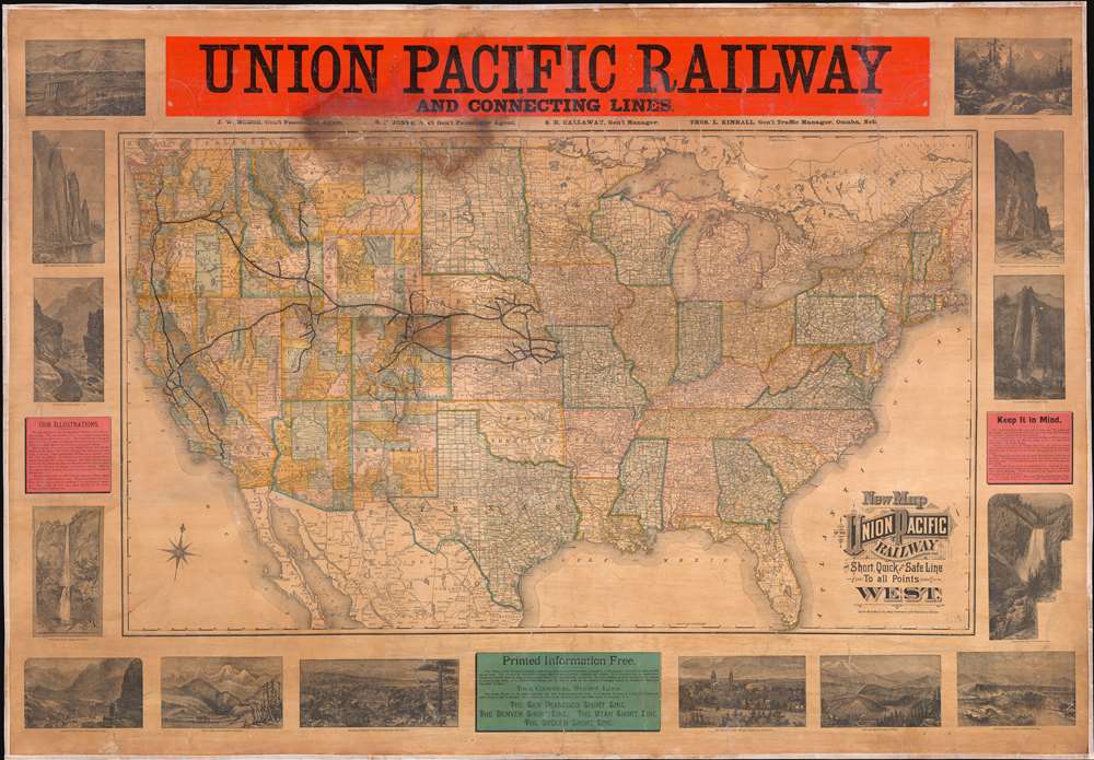
New Map of the Union Pacific Railway, the Short, Quick and Safe Line to all Points West.
1887 (undated) 39.5 x 57 in (100.33 x 144.78 cm) 1 : 4000000
1887 (undated) 39.5 x 57 in (100.33 x 144.78 cm) 1 : 4000000
Description
This rarity is a large format 1887 wall map of the United States issued by Rand McNally and Company on behalf of the Union Pacific Railroad. This scarce railroad map was issued exclusive for company use at larger stations, and was not publicly distributed, hence its extreme rarity. There are no other examples of the current map known, but the Library of Congress does own an earlier 1883 edition. The map embraces the whole of the United Sates, illustrating the routes of the Union Pacific Railroad and its many subsidiaries, as well as, in some cases, important connecting routes operated by competing railroads. The map is surrounded by 14 vignette views engraved by the Matthews Northrup Company illustrating the spectacular sights and geographical oddities to be observed along the Union Pacific routes. Further textual advertisements promote the Union Pacific as the shortest, quickest, and safest route westward.
Promoting the Union Pacific
The map unabashedly promotes the luxury, sophistication, and economy of the Union Pacific Railroad network. Text at right of the map reads,The Union Pacific is the only route to Idaho and Wyoming, and the shortest route to Denver, Leadville, Salt Lake City, San Francisco, Portland, and Pacific Coast Points Generally. The Union Pacific is the only line from the Missouri River to points in the Far West, which can offer its patrons a choice of routes across the prairies to the Rocky Range. The Union Pacific is the Oregon Short Line, the California Short Line, the Colorado Short Line, in fact it is the Central Route and hence the Short Line to all pointes in the Rocky Mountains and on the Pacific Coast … When you go to Denver, Salt Lake, Helena, San Francisco, Portland, or anywhere West, be sure your tickets read via Union Pacific.And of course, they were correct. There were competing routes, but none offered the size and flexibility of the Union Pacific. By the early 20the century the Union Pacific had absorbed most competing lines and is today one of the world's largest railroad concerns.
The Mathews Northrup Views
The Union Pacific turned to the Buffalo, New York, publishing and engraving firm of Matthews Northrup to provide the 14 vignette views surrounding the map proper. The engraved views were intended to encourage tourism on the Union Pacific by illustrating the natural wonders to be seen along the way, among them Devil's Gate, Weber Canyon (Utah), Multnomah Falls (Oregon), Cape Horn Columbia River (Washington), Ogden (Utah), the Tetons (Wyoming), and Devil's Slide (Utah), among others.Changes to from the LOC 1883 Edition
We have noticed certain disparities between this and the 1883 LOC edition, most focusing on railroad development in Colorado, Nebraska, Washington, Oregon, and Kansas. These include the addition of the Belleville line in Kansas, which opened for operation in 1884. Also, in Custer county, Nebraska, the city of Broken Bow appears for the first time as the terminus of a railroad route. This route is present on the 1883 LOC map as well, despite the fact that it was not complete and operational until 1886, but Broken Bow is there identified as 'New Saint Helena' (perhaps an alternate name choice?). While our map is slightly more detailed, as one would expect form a later edition, the LOC map identifies more stops on the Union Pacific's Broken Bow line, while our map offers a more sophisticated layout of the 'Ord' line. In Colorado, our map exhibits significantly increased development to the south west of Denver, particularly in the vicinity of Gunnison. It also notes the narrow gage Denver and Rio Grande Western Railroad extending westward to meet with the Union Pacific a Provo City, Utah. There is a completely revised track configuration in Idaho and Montana in the vicinity of Missoula, Helena, and Virginia City. The most significant difference between editions is the addition of the Oregon and California Railroad, which was completed in 1887 and absorbed into the Southern Pacific system, finally directly connecting San Francisco with the Pacific Northwest.Publication History and Census
This map is rare and likely issued in small quantities for use only in large railway stations. The only other example we have been able to identify is located in the Library of Congress. That example has a secondary title, lacking here, and an 1883 copyright, also lacking here. However, a study of the routes updated on our map (see above) allows us to firmly date this map to 1887.CartographerS
Rand, McNally and Co. (fl. 1856 - present) is an American publisher of maps, atlases and globes. The company was founded in 1856 when William H. Rand, a native of Quincy, Massachusetts, opened a print shop in Chicago. Rand hired the recent Irish immigrant Andrew McNally to assist in the shop giving him a wage of 9 USD per week. The duo landed several important contracts, including the Tribune's (later renamed the Chicago Tribune) printing operation. In 1872, Rand McNally produced its first map, a railroad guide, using a new cost effective printing technique known as wax process engraving. As Chicago developed as a railway hub, the Rand firm, now incorporated as Rand McNally, began producing a wide array of railroad maps and guides. Over time, the firm expanded into atlases, globes, educational material, and general literature. By embracing the wax engraving process, Rand McNally was able to dominate the map and atlas market, pushing more traditional American lithographic publishers like Colton, Johnson, and Mitchell out of business. Eventually Rand McNally opened an annex office in New York City headed by Caleb S. Hammond, whose name is today synonymous with maps and atlases, and who later started his own map company, C. S. Hammond & Co. Both firms remain in business. More by this mapmaker...
Matthews-Northrup Works (fl. c. 1895 - 1930) were a Buffalo, New York based, in their own words, "writing, designing, engraving, printing, [and] binding" firm. The firm was founded by James Newson Matthews (November 21, 1828 - December 20, 1888) as the J. N. Matthews Company. William Phelps Northrup (April 2, 1850 - February 2, 1929) later joined the company as an apprentice and then partner, at which point the firm was reincorporated as the Matthews-Northrup Works. The Matthews-Northrup Works rose to prominence as publishers and printers of railroad maps, with dozens to their credit. When James died, his shares were inhered by George Edward Matthews (1855 - 1910), who ran the business until his death in 1910. Also in 1910, they famously redesigned the cover of National Geographic Magazine. Despite some six previous cover changes in just 21 years, the Matthews-Northrup layout proved so popular that it was used for nearly 50 years. The firm can also take credit for the Winchell typeface, designed in 1903 under E. E. Winchell's tenure as art director. Curiously, the partners of Matthews-Northrup maintained an unusual affectation in which only the officers of the company could wear beards or mustaches. In this same spirit, the firm also had its own private social club, the Fellowcraft Club, where the all-male employees could relax, play pool, drink and dine. Matthews-Northrup maintained offices on Washington Street, Buffalo, where they were based, as well as Madison Square, New York City, Garden Tower, Boston, and the Citizens Building in Cleveland. Learn More...
Condition
Good. Full professional restoration Cracking. Large discoloration top center. Backed on fresh linen.
References
Library of Congress,G3701.P3 1883 .R36. Library of Congress, Railroad maps, #595.