This item has been sold, but you can get on the Waitlist to be notified if another example becomes available, or purchase a digital scan.
1849 Atwood Gold Rush Map of the United States
UnitedStates-atwood-1849$1,750.00

Title
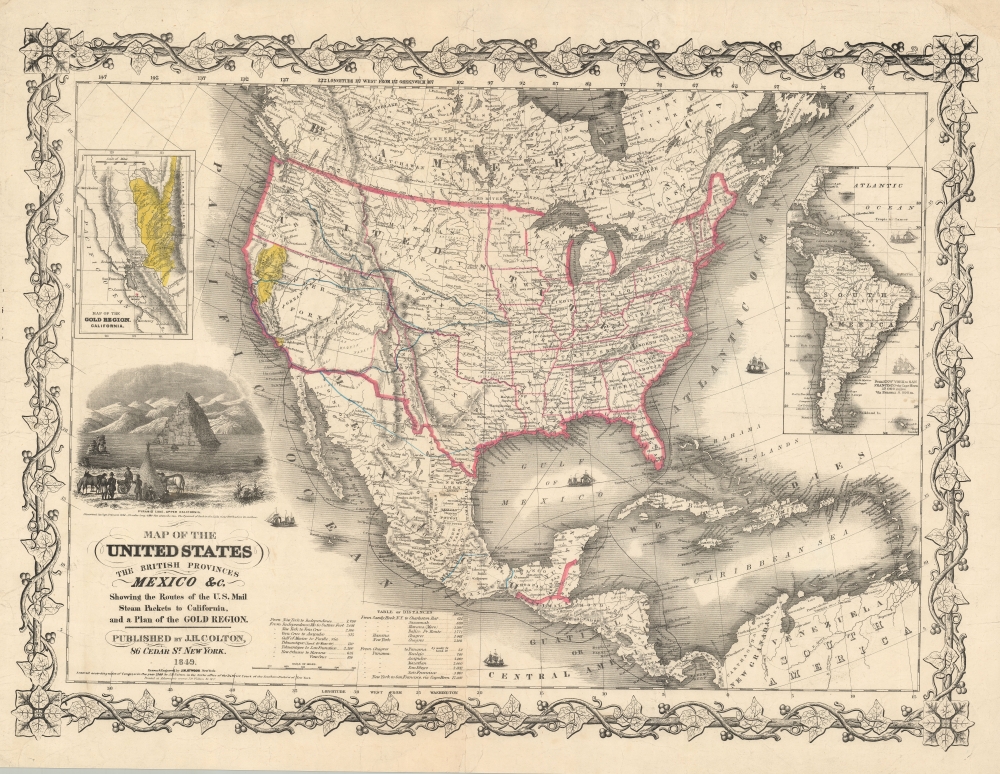
Map of the United States The British Provinces Mexico and c. Showing the Routes of the U.S. Mail Steam Packets to California and a Plan of the Gold Region.
1849 (dated) 19.5 x 25.5 in (49.53 x 64.77 cm) 1 : 14000000
1849 (dated) 19.5 x 25.5 in (49.53 x 64.77 cm) 1 : 14000000
Description
This is J. H. Colton and J. M. Atwood's 1849 map of the United States, issued to illustrate routes to the newly discovered gold fields in California. Issued immediately in the wake of the gold discovery at Sutter's Mill, this is the first Colton map to illustrate the California Gold Fields. It also Texas in its largest configuration, immediately after the Treaty of Guadalupe Hidalgo.
A Closer Look
This map is loosely based on the North American inset map on the huge Smith/Colton 1844 Map of the United States and the Canadas. It has been amended significantly to reflect new discoveries, the gold rush, and transportation routes. The map illustrates four overland routes to the gold fields, as well as several maritime routes illustrating passages through Mexico, Nicaragua, and Panama. Texas is illustrated with extensive boundaries according to its original 'Republic of Texas' claims, but tentative borders also suggest ongoing legislations regarding the creation of a 'Santa Fe or New Mexico' territory. Various American Indian nations are noted throughout with populations statistics - potentially valuable information for anyone headed overland to California. A large inset at rights detail the maritime route to the from New York, around Cape Horn, to San Francisco. Another inset, at left, highlights the gold Region, naming New Helvetia (Sutter's Fort) and the quicksilver mines near San Jose.The California Gold Rush
The discovery of gold at John Sutter's mill by James Wilson Marshall (1810 - 1885) in January of 1848 was one of the most definitive moments in American history. Coming at the end of the Mexican-American War (1846 - 1848), the timing of the discovery could not have been more propitious. The combination of new seemly unlimited territory and the lure of gold led to a stampede of adventurers, prospectors, merchants, and homesteaders eager for a new life on the frontier. The Gold Rush was not limited to Americans crossing the Great Plains. European, Australian, and even Chinese immigrants rushed into California hungry for their part of the great strike. This Great Migration transformed the United States in the span of just a few years from a former colony into an expansive transcontinental nation on the cusp of becoming a world power.Texas Borders
The borders of the Republic of Texas were in dispute from the earliest days of the Texan Revolution. The Republic-claimed borders followed the Treaties of Velasco between the newly created Texas Republic and Mexican leader, Antonio López de Santa Anna. The treaties established an eastern boundary following the 1819 Adams-Onís Treaty between the United States and Spain, which established the Sabine River as the eastern boundary of Spanish Texas and the western boundary of the Missouri Territory. The Republic's southern and western boundary with Mexico was more nuanced. Texas claimed the Rio Grande del Norte as its western and southernmost border, while Mexico argued for a boundary much further east at the Nueces River. When Texas was annexed into the United States, the agreement followed the Republic claimed boundary, thus absorbing Mexican claimed territory as far west as Santa Fe. This escalated already existing tensions between the United States, the former Republic of Texas, and Mexico, ultimately triggering the Mexican-American War (1846 - 1848).Pyramid Lake
The map features an engraved view of Pyramid Lake with travelers in the foreground. Pyramid Lake, located in present-day Nevada, was discovered in 1844 by the John C. Fremont Expedition. Named for the limestone tufa formations that resemble pyramids, this ancient lake, located in the state of Nevada, intrigued the expedition with its unique beauty and stark contrast to the surrounding desert landscape. In subsequent decades it became a significant landmark for emigrants heading west for the Gold Rush.Publication History and Census
This map was issued in two editions, both 1849. The first appeared in Fayette Robinson's California and its Gold Regions. It was later issued both separately and as a pocket map to accompany Colton's emigrant guide to California - one of the first. It was printed by Ackerman This is the second issue, distinguished by:- The addition of 'Printed at Ackerman's rooms 120 Fulton St. N.Y.' under copyright statement.
- The addition of 'New Orleans to Havana' and '[ditto] to Vera Cruz' with milage and removes those miles on the lines in the Gulf of Mexico linking those ports.
- On the inset map of the Gold Region, ' 'Quicksilver' below San Jose is changed to 'Quicksilver Mines'. The Stanislaus, Towalumnes, and Acumnes Rivers are added.
- Multiple minor changes to the vine border.
CartographerS
John M. Atwood (1817 - October 12, 1884) was an American engraver based in Philadelphia and New York City during the middle part of the 19th century. Atwood was born in Georgetown, near Washington D.C. Little is known of Atwood's life but most of his work was completed in conjunction with the publishing firms of Horace Thayer and J. H. Colton. A review of Atwood's work suggests that he was a highly accomplished, stylistically distinct, and detail oriented engraver. Colton seems to have turned to Atwood to engrave some of his most important as well as decorative maps. His most influential map is most likely the 1856 De Cordova pocket map of Texas, however, he also engraved the Colton's well known and highly decorative Thirty Three Miles Around New York and Colton's important 1849 Map of the United States. More by this mapmaker...
Joseph Hutchins Colton (July 5, 1800 - July 29, 1893), often publishing as J. H. Colton, was an important American map and atlas publisher active from 1833 to 1897. Colton's firm arose from humble beginnings when he moved to New York in 1831 and befriended the established engraver, Samuel Stiles. He worked under Stiles as the 'Co.' in Stiles and Co. from 1833 to 1836. Colton quickly recognized an emerging market in railroad maps and immigrant guides. Not a cartographer or engraver himself, Colton's initial business practice mostly involved purchasing the copyrights of other cartographers, most notably David H. Burr, and reissuing them with updated engraving and border work. His first maps, produced in 1833, were based on earlier Burr maps and depicted New York State and New York City. Between 1833 and 1855, Colton proceeded to publish a large corpus of guidebooks and railroad maps, which proved popular. In the early 1850s, Colton brought his two sons, George Woolworth Colton (1827 - 1901) and Charles B. Colton (1832 - 1916), into the map business. G. W. Colton, trained as a cartographer and engraver, was particularly inspired by the idea of creating a large and detailed world atlas to compete with established European firms for the U.S. market. In 1855, G.W. Colton issued volume one of the impressive two-volume Colton's Atlas of the World. Volume two followed a year later. Possibly because of the expense of purchasing a two-volume atlas set, the sales of the Atlas of the World did not meet Colton's expectations, and so, in 1856, the firm also issued the atlas as a single volume. The maps contained in this superb work were all original engravings, and most bear an 1855 copyright. All of the maps were surrounded by an attractive spiral motif border that would become a hallmark of Colton's atlas maps well into the 1880s. In 1857, the slightly smaller Colton's General Atlas replaced the Atlas of the World. Most early editions of the General Atlas published from 1857 to 1859 do not have the trademark Colton spiral border, which was removed to allow the maps to fit into a smaller format volume. Their customers must have missed the border because it was reinstated in 1860 and remained in all subsequent publications of the atlas. There were also darker times ahead; in 1858, Colton was commissioned at a sum of 25,000 USD by the government of Bolivia to produce and deliver 10,000 copies of a large format map of that country. Although Colton completed the contract in good faith, delivering the maps at his own expense, he was never paid by Bolivia, which was at the time in the midst of a series of national revolutions. Colton would spend the remainder of his days fighting with the Bolivian and Peruvian governments over this payment, and in the end, after a congressional intervention, he received as much as 100,000 USD in compensation. Nonetheless, at the time, it was a disastrous blow. J. H. Colton and Company is listed as one of New York's failed companies in the postal record of 1859. This led Colton into the arms of Alvin Jewett Johnson and Ross C. Browning. The 1859 edition of Colton's General Atlas lists Johnson and Browning as the 'Successor's to J. H. Colton' suggesting an outright buyout, but given that both companies continued to publish separately, the reality is likely more complex. Whatever the case may have been, this arrangement gave Johnson and Browning access to many of Colton's map plates and gave birth to Johnson's New Illustrated (Steel Plate) Family Atlas. The Johnson's Atlas was published parallel to Colton's atlases well into the 1880s. The Colton firm itself subsequently published several other atlases including an Atlas of America, the Illustrated Cabinet Atlas, the Octavo Atlas of the Union, and Colton's Quarto Atlas of the World. They also published a large corpus of wall maps, pocket maps, and guides. The last known publications of the Colton firm date to 1897 and include a map and a view, both issued in association with the Merchant's Association of New York. Alice M. Colton married August R. Ohman (May 3, 1859 - April 22, 1934) on January 5, 1897. In 1898, Ohman joined the Colton firm, which continued to publish as Colton, Ohman & Co. until 1901. Learn More...
James Ackerman (1816 - March 24, 1864) was an American painter, engraver, and lithographer active in New York City in the mid-19th century. Ackerman was born in New York. He rose to prominence as a lithographer and painter - best known for his floral prints, some of which were favorably lauded by none other than Edgar Allen Poe. He was also associated with the banner and sign painting firm of Ackerman and Miller until his death. His offices were at 120 Fulton Street and later at 379 Broadway. He frequently printed for the U.S. government, including work for the U.S. Coast Survey and the General Land Office. I have found few references to what happened to Ackerman later in life, but his residence at death is identified as the Bloomingdale Insane Asylum. Ackerman is interred in Brooklyn at Greenwood Cemetery. Learn More...
Condition
Good. Overall toning. Laid down on archival tissue. Slight infill on centerfold.
References
Library of Congress, G3700 1849 .A72 TIL. Boston Public Library, G3700 1849 .C65x. Rumsey 0170.001.