This item has been sold, but you can get on the Waitlist to be notified if another example becomes available, or purchase a digital scan.
1786 Sayer and Dunn Map of the United States
UnitedStates-dunn-1786$700.00

Title
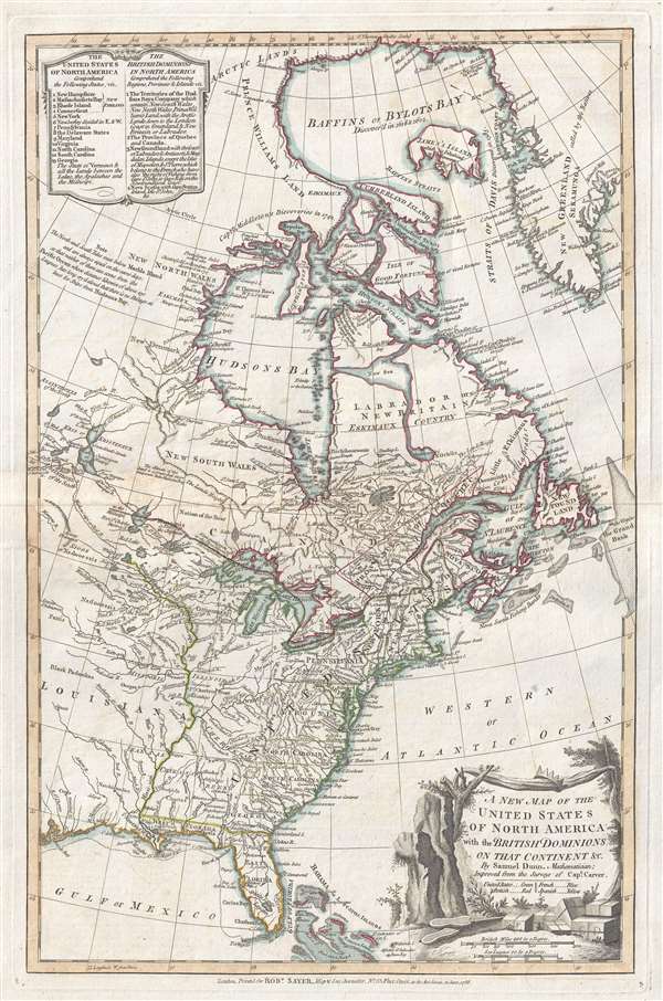
A New Map of the United States of North America with the British Dominions on that Continent…
1786 (dated) 20 x 13 in (50.8 x 33.02 cm) 1 : 14500000
1786 (dated) 20 x 13 in (50.8 x 33.02 cm) 1 : 14500000
Description
This rare 1786 map of the United States by Samuel Dun and Robert Sayer is one of the earliest obtainable English maps to embrace the term 'United Sates.' The map was prepared by Samuel Dunn, a British mathematician, based upon earlier maps by Sayer and significantly updated by the explorations of Jonathan Carver. Centered on the Great Lakes, it covers from Baffin Bay to Florida and the Gulf of Mexico, and from Lake Winnipeg to Greenland, the Atlantic seaboard, and the Grand Banks.
One of the Earliest British Maps to Name the United States
This map reflects a changing British perspective on the United States. Published shortly after the Treaty of Paris formally ended the American Revolutionary War, the British were forced to concede the existence of a large and powerful new country. British mapmakers were slow to respond to the new geography, with the present map being one of the earliest British commercial maps to embrace the newly forged United States.The cartographer, nonetheless, leaves a fair amount of ambiguity with regard to the borders. The Western border of the United States, in the vicinity of modern day Minnesota, is left unmarked while to the south and north borders with Spanish Louisiana and British Canada are clearly defined. It is noteworthy that all of Lake Michigan then, as now, falls within the United States.
Indistinct State Borders and Conflict
The individual states themselves also exhibit ambiguous borders west of the Appalachian Mountains. The new states that would eventually emerge in this region, Tennessee, Kentucky, Illinois, Alabama, and Ohio, are as yet almost exclusively American Indian territories. Notably the coast to coast grants originally offered to North Carolina, South Carolina, and Georgia, are clearly rejected. Some of these ambiguous boundaries would eventually lead to disputes between the states such as the Third Pennamite War (1774), fought over the Wyoming Valley and the northern boundary of Pennsylvania.
A Denial of the Northwest Passage
The British, Americans, and French all realized the potential profit of a Northwest Passage. Expedition after expedition was launched into the Artic, discovering Hudson and Baffin Bay – but no route to the Pacific. In the late 18th century, it was long hoped that a passage might be still be found from the Hudson Bay leading westward to the Pacific and, thus, the rich markets of Asia. Dunn here boldly rejects the notion,
This map drawn by Samuel Dunn and engraved by Robert Sayer. A variant was originally published under the imprint of Sayer and Bennett with the title A Map of the British Empire in North America. A second issue was published in 1776 to in British wartime interest in maps of America. The plate was altered in 1783 to reflect the Treaty of Paris. This fourth issue is as the third issue, but with Sayer's 1786 imprint in the lower margin. It is reasonably scarce and appears on the market infrequently.
One of the Earliest British Maps to Name the United States
This map reflects a changing British perspective on the United States. Published shortly after the Treaty of Paris formally ended the American Revolutionary War, the British were forced to concede the existence of a large and powerful new country. British mapmakers were slow to respond to the new geography, with the present map being one of the earliest British commercial maps to embrace the newly forged United States.
Indistinct State Borders and Conflict
The individual states themselves also exhibit ambiguous borders west of the Appalachian Mountains. The new states that would eventually emerge in this region, Tennessee, Kentucky, Illinois, Alabama, and Ohio, are as yet almost exclusively American Indian territories. Notably the coast to coast grants originally offered to North Carolina, South Carolina, and Georgia, are clearly rejected. Some of these ambiguous boundaries would eventually lead to disputes between the states such as the Third Pennamite War (1774), fought over the Wyoming Valley and the northern boundary of Pennsylvania.
A Denial of the Northwest Passage
The British, Americans, and French all realized the potential profit of a Northwest Passage. Expedition after expedition was launched into the Artic, discovering Hudson and Baffin Bay – but no route to the Pacific. In the late 18th century, it was long hoped that a passage might be still be found from the Hudson Bay leading westward to the Pacific and, thus, the rich markets of Asia. Dunn here boldly rejects the notion,
The North and South Tides meet below Marble Island and are always equal on the same days; so that neither of them can come from the Pacific Ocean whose distance likewise of above 430 leagues, has long cry'd aloud that there is no Passage at least for Ships from Hudson Bay.He does, nonetheless, embrace the cartography of Carver, who believed he had discovered an inland river passage to the Pacific. This he suggestively illustrates via a vast network of rivers extending from Lakes Superior, past the Lake of the Woods, as far as Lake Winnipeg, with additional unexplored rivers extending further west. This cartography, he believed, would eventually load to the Pacific. Ultimately, French Canadian coureurs des bois would discover the westward river passage, but not until the early 19th century.
This map drawn by Samuel Dunn and engraved by Robert Sayer. A variant was originally published under the imprint of Sayer and Bennett with the title A Map of the British Empire in North America. A second issue was published in 1776 to in British wartime interest in maps of America. The plate was altered in 1783 to reflect the Treaty of Paris. This fourth issue is as the third issue, but with Sayer's 1786 imprint in the lower margin. It is reasonably scarce and appears on the market infrequently.
CartographerS
Samuel Dunn (1723 - January 1794) was a teacher of mathematics, navigation, and astronomy, an engraver, and a publisher active in London, England, during the second half of the 18th century. Dunn was born in Crediton, Devonshire, England. He was active as a teacher of navigation, running his own school, as early as 1742, when he was just 19. In 1758 Dunn became master of an academy at Ormond House, Paradise Row, Chelsea, London. He is credited with observing the transit of a comet in January of 1760 and the thrust of Venus in 1761. Dunn was a member of the Commission for the Discovery of the Longitude at Sea. As such he was one of the few teachers appointed to issued ship masters with 'Certificates of Competence' for the Board of Longitude. Dunn was also an official teacher of navigation for the East India Company and succeeded William Herbert as the editor of the New Directory for the East Indies. He published a number of scientific and astronomical texts as well as several important maps and charts. He lived until his death at No. 1 Boar's Head Court, Fleet Street, London, England. More by this mapmaker...
Robert Sayer (1725 - January 29, 1794) was an important English map publisher and engraver active from the mid to late 18th century. Sayer was born in Sunderland, England, in 1725. He may have clerked as a young man with the Bank of England, but this is unclear. His brother, James Sayer, married Mary Overton, daughter-in-law of John Overton and widow of Philip Overton. Sayer initially worked under Mary Overton, but by December of 1748 was managing the Overton enterprise and gradually took it over, transitioning the plates to his own name. When Thomas Jefferys went bankrupt in 1766, Sayer offered financial assistance to help him stay in business and, in this way, acquired rights to many of the important Jefferys map plates as well as his unpublished research. From about 1774, he began publishing with his apprentice, John Bennett (fl. 1770 - 1784), as Sayer and Bennett, but the partnership was not formalized until 1777. Bennett retired in 1784 following a mental collapse and the imprint reverted to Robert Sayer. From 1790, Sayer added Robert Laurie and James Whittle to his enterprise, renaming the firm Robert Sayer and Company. Ultimately, Laurie and Whittle partnered to take over his firm. Sayer retired to Bath, where, after a long illness, he died. During most of his career, Sayer was based at 53 Fleet Street, London. His work is particularly significant for its publication of many British maps relating to the American Revolutionary War. Unlike many map makers of his generation, Sayer was a good businessman and left a personal fortune and great estate to his son, James Sayer, who never worked in the publishing business. Learn More...
Jonathan Carver (April 13, 1710 - January 31, 1780) was an American explorer, cartographer, and writer active during the colonial period. He was born in Weymouth, Massachusetts and, During the French and Indian War (1754 - 1763), saw action with the famous 'Roger's Rangers'. During the war, he was able to learn mathematics and military surveying. He was elevated to captain and given charge of a regiment in 1761. When the war ended, Carver was determined to explore the new British territories ceded by the Treaty of Paris. In 1766, he was hired by the leader of Robert's Rangers, frontiersman and Royal Governor Robert Rogers (1731 - 1795), to join an expedition in search of an interior water route between the Mississippi and the Pacific. With Rogers, he explored parts of the Upper Mississippi basin in modern-day Wisconsin, Minnesota, and Iowa. In 1769, the expedition ended with significant new cartography. Carver believed he may have found a water route to the Pacific - likely the Missouri. In the meantime, Rogers, his patron, was arrested and court-martialed for treason. Carver was caught in the fallout from Rogers' court-martial, and his discoveries were never formally recognized. Seeking redress from the crown, Carver traveled to England, where his requests were heard, though he never received his hoped-for reward for discovering the Northwest Passage. Carver's cartographic information was passed to Robert Sayer, who incorporated some of it into his maps. While in England, Carver also completed his memoirs, published in 1778 as Travels through the Interior Parts of North America, in the Years 1766, 1767 and 1768. He died one year later in 1780. In 1804, several of Carver's descendants portioned the U.S. Congress for ownership of an extensive land grant in Wisconsin Territory - the Carver Grant - apparently ceded to him by the Sioux in exchange for 'many gifts'. The U.S. Congress denied the (probably) fraudulent claims, and the grant was voided despite appearing on maps well into the 1840s. Learn More...
Source
Dunn, S., A New Atlas of the Mundane System, (London: Robert Sayer) 1786.
Condition
Very good. Light transference.
References
OCLC 852833294.