This item has been sold, but you can get on the Waitlist to be notified if another example becomes available, or purchase a digital scan.
1899 National Publishing Company Wall Map of the United States
UnitedStates-nationalpublishing-1899$312.50


Title
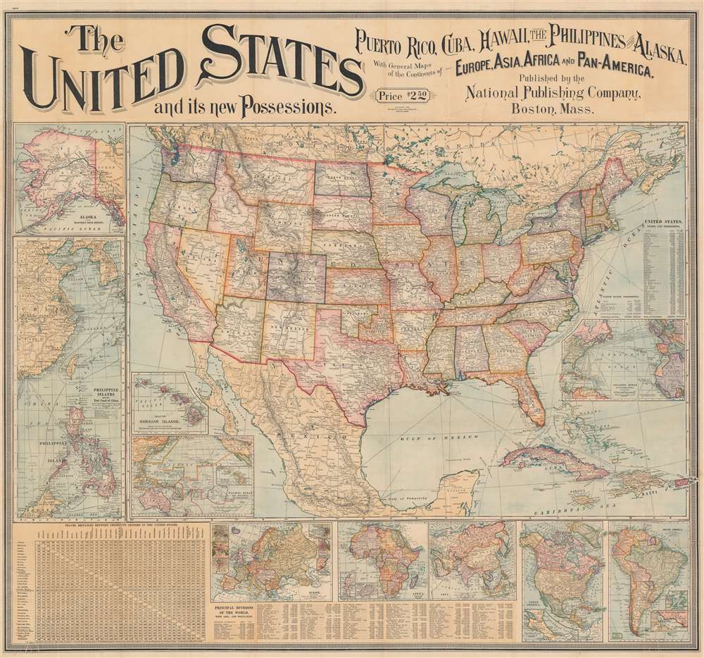
The United States and its new Possessions. Puerto Rico, Cuba, Hawaii, the Philippines and Alaska, With General Maps of the Continents of Europe, Asia, Africa, and Pan-America.
1899 (dated) 34.75 x 37.75 in (88.265 x 95.885 cm) 1 : 7100000
1899 (dated) 34.75 x 37.75 in (88.265 x 95.885 cm) 1 : 7100000
Description
This is an 1899 National Publishing Company wall map of the United States published shortly after the Spanish-American War. The map of the United States dominates the sheet, with the country's railroad network, river systems, and mountain ranges all appearing. However, given the recent victory over Spain during the war and the acquisition of Puerto Rico, the Philippines, and Guam, along with Cuba as a protectorate, the Caribbean islands and the insets likely would have commanded just as much, if not more, attention from a contemporary audience. Dashed lines trace Plant Steamship Lines and Florida East Coast Steam Ship Lines routes in the Caribbean from Florida, informing viewers how Americans could visit their newly acquired overseas 'empire'. Cuba's rail network is illustrated as well.
The Insets
Insets appear along the left and bottom borders. Perhaps the most intriguing is the inset of the Philippines, which situates the archipelago in relation to China, Taiwan (Formosa), Korea, and Borneo. Shipping lanes are marked here as well, underscoring the Philippines importance in regional trade. An inset of Alaska (acquired from Russia in 1867) occupies the upper left corner. An inset of Hawaii (annexed in 1898) appears to the right of the inset of the Philippines and China just above an inset of the Pacific Ocean. The Pacific Ocean map situated the Philippines and Hawaii with relation to the U.S. West Coast, although it does not necessarily convey just how vast the distances are between these islands. Insets of Europe, Africa, Asia, and the Americas occupy the bottom border with a table of distances within the United States in the lower left corner.The Spanish-American War
The Spanish-American War was fought between Spain and the United States between April 21, 1898, and August 13, 1898. The war started after the USS Maine suffered a massive explosion and sank in Havana Harbor. Tensions had been rising between the two countries for some time, with the U.S. showing support for Cuban independence while Spain claimed Cuba to be a province of Spain. After the fighting ended, the U.S. received the Philippines, Guam, and Puerto Rico along with Cuba as a U.S. protectorate.Publication History and Census
This map was created and published by the National Publishing Company in 1899. We note two cataloged examples in OCLC which are part of the collections at the University of Michigan and Harvard University.Cartographer
National Publishing Company (1897 - 1902) was an American map publishing firm founded in Portland, Maine in 1897. The founders, brothers Walter C. Scarborough (June 4, 1862 - May 9, 1904) and Howard G. Scarborough (December 23, 1867 - June 10, 1905), were also proprietors of the Scarborough Company and the Dominion Publishing Company. The National Publishing Company was intended to be managed by Howard, with Walter serving as treasurer. By 1901, the firm had relocated to Boston, where it published and sold large scale brilliantly printed road maps. In 1902, the Scarborough brothers merged their three concerns into the Boston based Scarborough Company and opened an office in Indianapolis, Indiana. Walter and Howard died in 1904 and 1905, both from tuberculous, but the Scarborough Company continued, transferring its offices to Indianapolis. In 1913 it became the Scarborough Motor Guide Company (c. 1913 - c. 1933). It does not appear to be related to the more prominent general publisher of the same name based out of Philadelphia. More by this mapmaker...
Condition
Good. Light wear along original fold lines. Verso repairs at nearly every fold intersection. Small areas of infill at many fold intersections.
References
OCLC 1291410800, 61184106.