This item has been sold, but you can get on the Waitlist to be notified if another example becomes available, or purchase a digital scan.
1848 Phelps National Map of the United States (Pocket Map)
UnitedStates-phelps-1848$400.00

Title
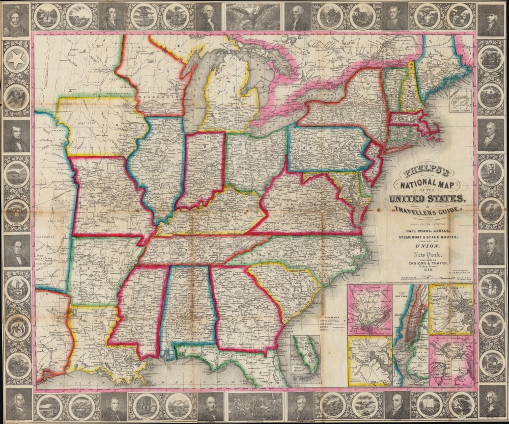
Phelps’s National Map of the United States, A Travellers Guide. Embracing the Principal Rail Roads, Canals, Steam Boat and Stage Routes throughout the Union.
1848 (dated) 21.25 x 25.5 in (53.975 x 64.77 cm) 1 : 4500000
1848 (dated) 21.25 x 25.5 in (53.975 x 64.77 cm) 1 : 4500000
Description
This is the 1848 issue of the first state of Phelps's map of the United States. The map was issued during the Mexican-American War (1846 - 1848), and as such captures an ephemeral moment in American history: after Texas joined the Union, but before the Treaty of Guadeloupe-Hidalgo and the annexation of Upper California.
A Closer Look
Coverage embraces the United States as far west as Texas and the Missouri Territory. Cities, towns, and villages are labeled, along with the nation's roads and a fast growing network of railroads. Inset maps in the lower right illustrate seven important cities: New York, Philadelphia, Baltimore, Boston, Birmingham, Cincinnati, St. Louis, and Chicago. Two smaller inset maps focus on southern Florida and Northern Maine respectively, the extremes of both of which extend beyond the map's borders. The whole is surrounded by a fine decorative border depicting 30 alternating state seals and portraits of 16 historical figure, many of whom are American Presidents. The state seal of Texas appears in the upper left. The 'Trader's Route to Santa Fe' is illustrated passing through Missouri and the territory to the west. Numerous American Indian tribes are identified throughout, as well as Indian Burial Grounds, and trading depots.Phelps's Traveller's Guide
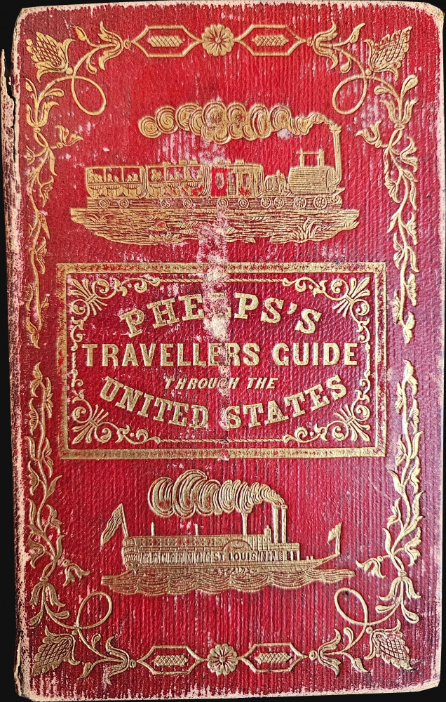
This map was issued to accompany Phelps's Travellers' Guide through the United States; containing Upwards of seven hundred Rail-road, Canal, and Stage and Steam-boat Routes, accompanied with a New Map of the United States. This 70-page booklet features an index of place names as well as mileage charts between important cities on rail and stage routes.Publication History and Census
This map was drawn and engraved by J. M Atwood of New York and the portraits and state seals were engraved by William D. Smith. It was published by Ensigns and Thayer in 1848. We note 7 examples cataloged in OCLC which are part of the collections at Yale University, Harvard University, the Indiana State Library, the University of Chicago, the Tennessee State Library and Archives, and the University of Minnesota Twin Cities. A few similar editions were published. Ensign and Thayer issued a similar map in the same year that differs from this one only in that a map of Pittsburgh is substituted for the Philadelphia inset. Later editions (published after 1849) replace all seven city plans with a mini map of the western United States. There is also a German language edition issued in 1849.CartographerS
Humphrey Phelps (1799 - 1875) was an American map, broadside, and book publisher based in New York City. Phelps was born in 1799 in Hebron, Connecticut. Phelps' earliest work seems to be a plan of New York City for his Stranger's Guide, dating to about 1830. Between 183- and 1837 he published with Bela Scovil Squire (1786 - 1861) under the imprint of Phelps and Squire. The New York map publishing circle seems to have been quite close and Phelps commonly partnered with various other New York publishers and printers including Edward H. Ensign (1818 - 1871), Horace Thayer, Erastus Clark Bridgman (1817 - 1870), Thomas C. Fanning (1805 - 1873), Hooker, Peabody, Charles Magnus, Gaylord Watson, and George Walker, among others. The natural consequence of his rampant partnering is a vast and varied corpus of work including many scarce items with low print runs. Phelps is best known for his emigrant and tourist guides. More by this mapmaker...
Edward Hooker Ensign (August 18, 1818 - July 10, 1871) was an American map and print publisher based in New York during the middle part of the 19th century. Edward was born in West Hartland, Connecticut. Little is known of Ensign's training but he may have inherited his business from his father, Timothy Ensign (1795 - 1859), who was a map publisher active in New York. Ensign seems to have had a flair for partnerships and variously published with Humphrey Phelps (1799 - 1875), Horace Thayer, Thomas C. Fanning (1805 - 1873) and Erastus C. Bridgman (1817 - 1870), among others. His various imprints include 'Phelps and Ensign' (1841-1844), 'T. and E. H. Ensign' (1844-1848), 'Ensign and Thayer' (1849), 'Ensign, Thayer, and Company' (1850-1851), 'Horace Thayer and Company' (1852), and 'Ensign, Bridgman and Fanning' (1854-1863). It appears that father and son worked together for some time as well, publishing as either 'T. and E. H. Ensign' or 'Ensigns'. At least some of these companies maintained offices in both Buffalo and New York City. Learn More...
Timothy Ensign (September 29, 1795 - September 16, 1849) was a map publisher based in Hartford, Connecticut, active in the early to mid-19th century. Early in his career, Timothy Ensign worked closely with the Hartford both D. W. Kellogg (1836 - 1841) and E. B. and E. C. Kellogg (1842 - 1848). From 1835, he also partnered with his son, Edward Hooker Ensign (1818 - 1871), and Horace Thayer (1811 - 1875) under the imprint of 'Ensigns and Thayer', until his untimely death in 1849 - after which the firm was renamed in the singular, 'Ensign and Thayer'. Learn More...
Horace Thayer (June 29, 1811 - March 15, 1875) was a New York based publisher and lithographer active in New York City and Buffalo, New York, during the middle part of the 19th century. Thayer's publications focused on travel guides, wall, and pocket maps - many of which were based on the works of other American cartographers including J. H. Colton and S. A. Mitchell. In the 1840s, he partnered with the Hartford, Connecticut publisher Timothy Ensign (1795 - 1849) and later his son, Edward Hooker Ensign (1818 - 1871). According to map historian Walter Ristow, J. H. Colton's older son, George Washington Colton, partnered with Thayer in the late 1850s and early 1860s, possibly in order to learn Thayer's lithography techniques. Certainly a number of maps emerged bearing a 'Thayer and Colton' imprint. At various points Thayer also published with other prominent publishers and printmakers, publishing as Kelloggs and Thayer (1846 - 1847), Ensigns and Thayer (1848), Ensign and Thayer (1849 - 1850), and Ensign, Thayer, and Company (1850 - 1851), Phelps and Watson (1859), and Thayer and Colton (1859-186?). Thayer seems to have moved frequently and had offices at 50 Ann Street, 156 William Street, and at 18 Beekman Street, all in New York City. Learn More...
John M. Atwood (1817 - October 12, 1884) was an American engraver based in Philadelphia and New York City during the middle part of the 19th century. Atwood was born in Georgetown, near Washington D.C. Little is known of Atwood's life but most of his work was completed in conjunction with the publishing firms of Horace Thayer and J. H. Colton. A review of Atwood's work suggests that he was a highly accomplished, stylistically distinct, and detail oriented engraver. Colton seems to have turned to Atwood to engrave some of his most important as well as decorative maps. His most influential map is most likely the 1856 De Cordova pocket map of Texas, however, he also engraved the Colton's well known and highly decorative Thirty Three Miles Around New York and Colton's important 1849 Map of the United States. Learn More...
Condition
Good. Wear and toning along original fold lines. Verso repairs to fold separations and at fold intersections. Small areas of infill at fold intersections. Old tape repairs evident on verso with some showthrough. Accompanied by original binder and guidebook.
References
Wheat, C. I., Mapping the Transmississippi West, 1540-1861 (5 vols), page 731. OCLC 27908973.