
This item below is out of stock, but another example (left) is available. To view the available item, click "Details."
Details
1862 J. Calvin Smith and Colton Folding Wall Map of the United States
1862 (dated0 $7,500.00
1849 J. Calvin Smith Case format Wall Map of the United States
UnitedStates-smith-1849$4,750.00

Title
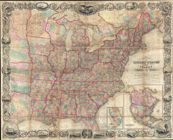
Map of the United States of America Including Canada, and a large portion of Texas, Showing Base Meridian and Township Lines of the U.S. Surveys, Including Lands alotted to the Indian Tribes west of the Mississippi, The various internal improvements.
1849 (dated0 66 x 83 in (167.64 x 210.82 cm) 1 : 1500000
1849 (dated0 66 x 83 in (167.64 x 210.82 cm) 1 : 1500000
Description
A striking large format 1849 case map of the United States by J. Calvin Smith. The map covers from Austin Texas to the eastern seaboard and from Lake Superior to the Gulf of Mexico. When it was introduced, this map was hailed as the largest, best, and most detailed map of the United States yet published. Smith based this map on the earlier cartographic work of John Arrowsmith.
Smith's 1847 promotional for the map advertises it as
Of particular note is the map's impressive decorative boarder in which acanthus leaves embrace countless vignettes of American flora and fauna, American Indians, important cities, monuments, and more. At the top of the map a large eagle gripping the shield of the United States surrounded by 26 starts, each representing a state and containing a vignette. Four additional stars, which are partially shaded, include Iowa, Wisconsin, Texas, and another unidentifiable possible state.
The map may have been issued as an optional accompaniment to D. Haskel and J. Calvin Smith's A complete descriptive and statistical gazetteer of the United States of America. It was also issued independently as a wall map mounted on rollers. It was first published in 1843 with updates and revisions to 1852. In 1853 the plate was acquired to J. H. Colton, who changed the border and made major geographical revisions throughout. All examples are rare.
Smith's 1847 promotional for the map advertises it as
The largest and most complete Map of the United States ever published, being about six feet by seven, showing the base, meridian, and Township lines of the United States Surveys, the land allotted to the different Indian tribes west of the Mississippi river …. The above work obtained the premium, a silver medal, at the late Fair of the American Institute, New-York, as the best and most accurate specimen of Map engraving..There are two inset maps in the lower right quadrant of southern Florida and North America. The southern Florida map identifies Miami and attempts to illustrate speculative islands in the everglades. The North America Map covers all of North America in the post Mexican-American War configuration with Texas illustrated at its fullest extent including the northern panhandle. Upper California includes 'Mormon Settlement' at the site of modern day Salt Lake City and identifies the Gold Region near the Sacramento River. Johann (John) Augustus Sutter's failed settlement of New Helvetia is noted.
Of particular note is the map's impressive decorative boarder in which acanthus leaves embrace countless vignettes of American flora and fauna, American Indians, important cities, monuments, and more. At the top of the map a large eagle gripping the shield of the United States surrounded by 26 starts, each representing a state and containing a vignette. Four additional stars, which are partially shaded, include Iowa, Wisconsin, Texas, and another unidentifiable possible state.
The map may have been issued as an optional accompaniment to D. Haskel and J. Calvin Smith's A complete descriptive and statistical gazetteer of the United States of America. It was also issued independently as a wall map mounted on rollers. It was first published in 1843 with updates and revisions to 1852. In 1853 the plate was acquired to J. H. Colton, who changed the border and made major geographical revisions throughout. All examples are rare.
CartographerS
John Calvin Smith (1809 – June 11, 1890) was an American surveyor and geographer active in New York during the middle part of the 19th century. He was a charter member of the American Geographical and Statistical Society (American Geographical Society). He worked with other important New York cartographers including John Disturnell, George Sherman, and Samuel Stiles, with whom he often published under the Stiles, Sherman & Smith imprint. Stiles may have introduced Smith to J. H. Colton, who acquired many of his map plates in 1853. Most of Smith's maps focus on New York counties, but he also issued maps of the United States, Illinois, Texas, and the California gold fields. Despite being an important and prolific cartographer, much of his personal life and history are shrouded in mystery. More by this mapmaker...
Sherman and Smith (fl. c. 1829 - 1855), sometimes working as Stiles, Sherman & Smith, were American engravers active in New York City during the middle part of the 19th century. The firm including John Calvin Smith (surveyor and engraver), George E. Sherman, and sometimes, Samuel Stiles. Their work primarily focused on government publications, including the maps and engravings prepared to illustrate the official records of the 1838-42 United States Exploring Expedition (U.S. Ex. Ex.), maps issued for the Army Corps of Topographical Engineers, and various U.S. Coast Survey Charts. They also engraved privately for Thomas Bradford and John Disturnell, among others. Sherman and Smith maintained offices at the corner of Broadway and Liberty Street in New York City and were highly regarded as the finest cartographic engravers in the city. Their non-cartographic legacies include George Inness, who apprenticed with them for two years before going on to become a well regarding American landscape painter of the Hudson River School. Learn More...
Condition
Very good. Map exhibits overall toning and soiling, but is otherwise in remarkable condition. Has original linen backing and edging, both stable. Accompanied by original gilt stamped binder.
References
Rumsey 2529.001. Phillips, P.L. (Maps) p.896. Wheat, Carl Irving, Mapping of the Transmississippi West, 1540-1861, 1471 (inset). . Ristow, W., American Maps and Mapmakers: Commercial Cartography in the Nineteenth Century, 318. OCLC 60688005, 41589181, 494980983.