
1853 Thayer Pictorial Wall Map of the United States

Pictorial Map of the United States.
Westward Expansion.
- Digital Map Information
- Suitable for large format printing
- DPI: 600
- File Size: 1802.6 MB
- File Type: ZIP / TIFF
- ICC color profile embedded
- Delivered instantly via download link
Westward Expansion.
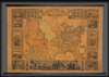
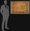
A highly decorative 1853 wall map of the United States is published by Horace Thayer and engraved by J. M. Atwood. This map was published in editions from 1847 - 58, covering thus the critical moments of the American westward expansion, with each edition being significantly updated to reflect the rapid changes endemic to that heady period. The present 4th edition example reveals major developments following the 1849 Gold Rush.A Closer Look
Coverage embraces the United States from Atlantic to Pacific and from Canada to the Gulf of Mexico. The Gold Region is highlighted with Sacramento and Sutter's City noted. The Great Salt Lake is presented in an embryonic form, indicative of the generally poor knowledge of the Great Basin predating the Railroad Surveys then being conducted. Salt Lake City itself is identified as 'Utah City of the Great Salt Lake.' The rail lines at this time extended westward no further than the Mississippi River, after which only wagon trails extended to the Pacific. Many of these are noted, including the 'Route to Oregon' (the famous Oregon Trail), the 'Route to Santa Fe,' and the southern route from 'Fort Smith to Santa Fe.' Other routes presented are the tracks of Fremont and the 'Great Spanish Trail from Los Angeles to Santa Fe.' Texas shows some development, including an emerging rail system running between Austin and the port of Galveston. Nebraska extends northwards to the Canadian border, and both Washington and Oregon have their eastern terminus at the Rocky Mountains. The apocryphal Lewis Fork or southern extension of the Columbia River, named after Meriwether Lewis, is shown in southeastern Oregon. American Indian nations are identified throughout. A smaller map of Mexico occupies the lower left.The Pictorial Surround
True its descriptive title, the map is surrounded by numerous pictorial vignettes illustrating, from the title clockwise: the Presidents of the United States, Perry's Opening of Japan, the Landing of the Pilgrims in 1620, farm tools, the 1846 Battle of Monterrey (Mexican American War), the United States House of Representatives Chamber, an illustration of Justice personified, the signing of the Declaration of Independence (largest illustration, bottom center), a personification of Liberty, the Senate Chamber, the capture of General La Vega in 1846 (Mexican American War), weapons and armor, the landing of Columbus in 1492, the Constitution and Guerriere (Navy Ships), and again, the Presidents.Publication History and Census
This map was first issued by Ensign and Thayer in 1847. It was republished by Ensign and Thayer in 1849 (Rumsey 5057), 1850, and 1852 (Rumsey 3508), and then in its present form by Thayer alone in 1853, and again by Ensign, Bridgman and Fanning in 1854 and 1855 (Rumsey 265). A final edition by Ensign, Bridgman and Fanning appeared in 1858.Cartographers
Horace Thayer (June 29, 1811 - March 15, 1875) was a New York based publisher and lithographer active in New York City and Buffalo, New York, during the middle part of the 19th century. Thayer's publications focused on travel guides, wall, and pocket maps - many of which were based on the works of other American cartographers including J. H. Colton and S. A. Mitchell. In the 1840s, he partnered with the Hartford, Connecticut publisher Timothy Ensign (1795 - 1849) and later his son, Edward Hooker Ensign (1818 - 1871). According to map historian Walter Ristow, J. H. Colton's older son, George Washington Colton, partnered with Thayer in the late 1850s and early 1860s, possibly in order to learn Thayer's lithography techniques. Certainly a number of maps emerged bearing a 'Thayer and Colton' imprint. At various points Thayer also published with other prominent publishers and printmakers, publishing as Kelloggs and Thayer (1846 - 1847), Ensigns and Thayer (1848), Ensign and Thayer (1849 - 1850), and Ensign, Thayer, and Company (1850 - 1851), Phelps and Watson (1859), and Thayer and Colton (1859-186?). Thayer seems to have moved frequently and had offices at 50 Ann Street, 156 William Street, and at 18 Beekman Street, all in New York City. Further Details...
John M. Atwood (1817 - October 12, 1884) was an American engraver based in Philadelphia and New York City during the middle part of the 19th century. Atwood was born in Georgetown, near Washington D.C. Little is known of Atwood's life but most of his work was completed in conjunction with the publishing firms of Horace Thayer and J. H. Colton. A review of Atwood's work suggests that he was a highly accomplished, stylistically distinct, and detail oriented engraver. Colton seems to have turned to Atwood to engrave some of his most important as well as decorative maps. His most influential map is most likely the 1856 De Cordova pocket map of Texas, however, he also engraved the Colton's well known and highly decorative Thirty Three Miles Around New York and Colton's important 1849 Map of the United States. Further Details...
Condition
Very good. Unrestored original condition.
References
Rumsey 5057.000 (1849), 5380.000 (1847). Manasek, F.J., Collecting Old Maps, p.49.