1814 Thomson Map of the United States and St. Lawrence River
UnitedStates-thomson-1814-2$500.00

Title
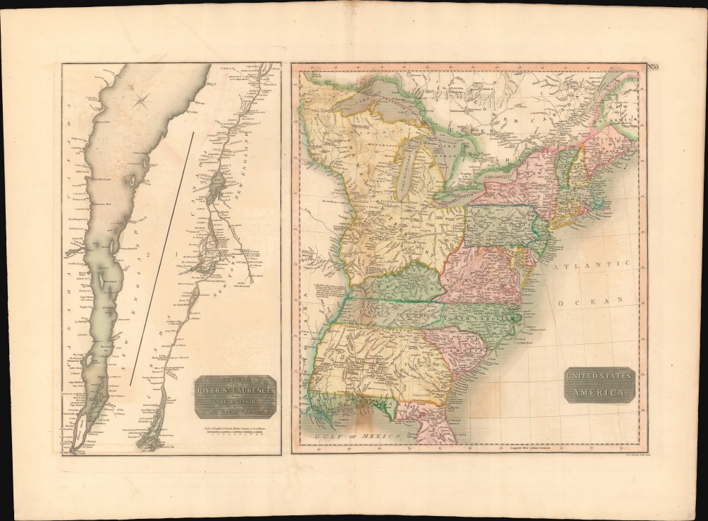
United States of America. / The Course of the River St. Lawrence, from Lake Ontario to Manicouagan Point.
1814 (undated) 17 x 24.5 in (43.18 x 62.23 cm) 1 : 5950000
1814 (undated) 17 x 24.5 in (43.18 x 62.23 cm) 1 : 5950000
Description
This is an example of John Thomson's 1814 map of the United States and the course of the St. Lawrence River. The map offers much of interest, ranging from early state and territorial configurations to rarely seen references to short-lived treaties with American Indians.
A Closer Look
This is two maps on one sheet: the right map focuses on the United States from the Mississippi River eastward to the Atlantic including the Great Lakes and adjacent parts of Ontario, Quebec, and Louisiana; and the left details the course of the St. Lawrence River from the Atlantic to Lake Ontario. The United States map presents an early statehood configuration with Georgia extending westward as far as the Mississippi to include modern-day Alabama, Florida divided into eastern and western territories, and the Great Lakes controlled by the Northwest Ordinance.East and West Florida
Florida is depicted according to an ephemeral division into eastern and western zones. This configuration emerged around 1810 when President James Madison annexed western Florida from Spain claiming it as part of the Louisiana Purchase. Though somewhat spurious, Madison's claim allowed the United States to take control of Mobile Bay thus opening an important artery into the interior of modern-day Alabama to America traders and settlers. East Florida was, at this time, still under Spanish control and would remain so until the Adams-Onis Treaty of 1821.Northwest Territory
The vast territory between the Ohio River, the Great Lakes, and the Mississippi is identified as the Northwest Territory, created in 1789 by the Northwest Ordinance. The Ordinance, or the Freedom Act, is considered the single most important act of legislation passed by the Continental Congress after the Declaration of Independence. Through the Northwest Territory, the Continental Congress established the conventions upon which the United States would expand westward. By consolidating sole distribution rights for all westward land sales into the federal government, the Congress established a precedent that would, in the course of the next 50 years, weaken the power of the individual states while simultaneously strengthening the federal government.Short-Lived American-Indian Treaty
In what would become Ohio, there is an unusual boundary line labeled 'Boundary Line by the Treaty of 1795'. This refers to the Treaty of Greenville. On August 20, 1794, an American army commanded by Anthony Wayne defeated a Native American force led by Blue Jacket of the Shawnee at the Battle of Fallen Timbers. The treaty that followed established United States hegemony over the region, forcing the American Indian nations to relinquish all claims to land south and east of a boundary that began roughly at the mouth of the Cuyahoga River, then turned southward to Fort Laurens, and then westward to Fort Laramie and Fort Recovery, then finally southward to the Ohio River. The U.S. government, in turn, relinquished claims to the territory north and west of the line. This was a short lived concession and rarely appears on maps.St. Lawrence
The left map focuses on the course of the St. Lawrence River from its mouth to Lake Ontario. The St. Lawrence was, at the time, an important artery for trade between the British territories in Quebec and Montreal and the American settlements along the Great Lakes.Publication History and Census
This map was prepared and engraved in 1814 in Edinburgh by J. and G. Menzies for inclusion in the 1817 first edition of John Thomson's New General Atlas.CartographerS
John Thomson (1777 - c. 1841) was a Scottish cartographer, publisher, and bookbinder active in Edinburgh during the early part of the 19th century. Thomson apprenticed under Edinburgh bookbinder Robert Alison. After his apprenticeship, he briefly went into business with Abraham Thomson. Later, the two parted ways, John Thomson segueing into maps and Abraham Thomson taking over the bookbinding portion of the business. Thomson is generally one of the leading publishers in the Edinburgh school of cartography, which flourished from roughly 1800 to 1830. Thomson and his contemporaries (Pinkerton and Cary) redefined European cartography by abandoning typical 18th-century decorative elements such as elaborate title cartouches and fantastic beasts in favor of detail and accuracy. Thomson's principle works include Thomson's New General Atlas, published from 1814 to 1821, the New Classical and Historical Atlas of 1829, and his 1830 Atlas of Scotland. The Atlas of Scotland, a work of groundbreaking detail and dedication, would eventually bankrupt the Thomson firm in 1830, at which time their plates were sequestered by the court. The firm partially recovered in the subsequent year, allowing Thomson to reclaim his printing plates in 1831, but filed again for bankruptcy in 1835, at which time most of his printing plates were sold to A. K. Johnston and Company. There is some suggestion that he continued to work as a bookbinder until 1841. Today, Thomson maps are becoming increasingly rare as they are highly admired for their impressive size, vivid hand coloration, and superb detail. More by this mapmaker...
John Menzies (October 27, 1772 - October 16, 1857) was a Scottish engraver active in Edinburgh during the late 18th and early 19th centuries. Menzies mastered engraving as an apprentice to James Rymer. In 1811, he partnered with his younger brother, George Menzies, to found the engraving firm of J. and G. Menzies, which was active until about 1831. Later his son, also named John, joined the firm and they engraved jointly under the imprint of J. Menzies and Son. At its height, the Menzies firm employed three men and three apprentices. Menzies engraved maps for Thomas Brown and John Thomson, among others. After his death, his son, John Menzies II (1819 – 1891), continued the family business until about 1891. Learn More...
Source
Thomson, J., A New General Atlas, (Edinburgh: Baldwin, Cradock, Joy) 1817.
Thomson's New General Atlas was first published in 1817 and continued to be published until about 1821. This is the first of Thomson's major cartographic works and the atlas for which is most celebrated. The New General Atlas follows in the Edinburgh School, which eschews excessive decoration in favor of a more minimalistic fact-based cartographic vision, as established by John Pinkerton, Laurie and Whittle, John Cary, and others in the previous decades. The maps are notable for their massive scale, heavy stock, elegant color work, and easy-to-read typefaces. Although the atlas stopped being published after 1821, Thomson continued to offer 'supplementary' maps that could be tipped into the atlas as late as 1830, when he declared bankruptcy. The maps in the Thomson Atlas were engraved by Thomas Clerk, William Dassauville, Nathaniel Rogers Hewitt, James Kirkwood, Robert Kirkwood, John Menzies, George Menzies, Edward Mitchell, John Moffatt, Samuel John Neele, Robert Scott, and James Wyld.
Condition
Good. Some offsetting. Original centerfold.
References
Rumsey 1007.061. Newberry Library: Ayer 135 T4 1817 no. 55.