This item has been sold, but you can get on the Waitlist to be notified if another example becomes available, or purchase a digital scan.
1867 General Land Office Map of the United States w/ Mineral Deposits
UnitedStates2-landoffice-1867$500.00

Title
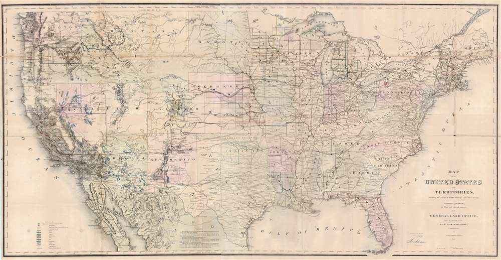
Map of the United States and Territories, Showing the extent of Public Surveys and other details, Constructed from the Plats and official sources of the General Land Office.
1867 (dated) 28.75 x 56 in (73.025 x 142.24 cm) 1 : 3800000
1867 (dated) 28.75 x 56 in (73.025 x 142.24 cm) 1 : 3800000
Description
This is an 1867 Joseph S. Wilson and Joseph Gorlinsky map of the United States illustrating the progress of U.S. government land surveys from coast to coast. The map depicts the entire United States from the Pacific Ocean to the Atlantic Ocean and from Canada to Mexico.
Townships and the Public Land Survey System
The map offers impressive detail, with township grids established throughout most of the middle states. As the map notes, large private claims of irregular shape (meaning that they did not fit into the nice, orderly grid instituted by the Public Land Survey System following the acquisition of the Northwest Ordnance) existed in Arkansas, Florida, Louisiana, and Missouri. The most intriguing geography lies further west. Dakota appears in an unusual configuration, after the creation of Montana, but before Wyoming, creating a unique 'puzzle-piece' situation since the Montana Territory acquired a large part of what had been called Dakota. Large portions of the western territories had not been surveyed, with only sporadic surveys appearing in Colorado, New Mexico, and Nevada. Older territories, such as California, Washington, and Oregon exhibit more comprehensive survey work, but remain incomplete. A key in the lower left notes that the large green dots throughout represent a surveyor general's office, while the smaller red dots indicate a land office, both of which played critical roles in these surveys.Mineral Deposits and other notations
The other smaller colored dots indicate mineral deposits. The minerals traced here include gold, silver, copper, quicksilver (mercury), iron, tin, asphalt, coal, and oil. Railroad lines throughout the west are illustrated and labeled, including several different proposed routes of the Union Pacific. American flags mark several places along the routes in Nebraska and Kansas, highlighting the distances the railroads had covered. American Indian reservations are identified throughout the west. In Indian Territory, for example, the land leased to specific tribes is noted. Mountains, rivers, and lakes are also illustrated.Census and Publication History
This map was drafted by Joseph Gorlinsky under the direction of Joseph S. Wilson, the Commissioner of the General Land Office, lithographed by Bowen and Company of Philadelphia, and published as part of the General Land Office's 1867 Annual Report.CartographerS
The General Land Office (GLO) (1812 - 1946) was an independent agency of the United States government responsible for public domain lands in the United States. Created in 1812, it took over functions previously conducted by the Department of the Treasury. The GLO oversaw the surveying, platting, and sale of public lands in the western United States. It also administered the Preemption Act of 1841, which allowed individuals who were already living on federal land to purchase up to 160 acres of land before it was offered for sale to the general public, if they met certain requirements. Following the passage of the Homestead Act in 1862, which was also administered by the GLO, claims under the Preemption Act sharply decreased. The GLO became a part of the newly-created Department of the Interior in 1849. In 1891 Grover Cleveland and Congress created 17 forest reserves, due to public concern over forest conservation, which were initially managed by the GLO, until they were transferred to the Forest Service in 1905. In 1946 the Government Land Office was merged with the United States Grazing Service to become the Bureau of Land Management. Today the Bureau of Land Management administers the roughly 246 million acres of public land remaining under federal ownership. More by this mapmaker...
Joseph Shields Wilson (c. 1806 - June 23, 1874) was an Irish-American immigrant who held positions in the U.S. Department of the Treasury and the U.S. Department of the Interior. Born in Ireland, Wilson immigrated to the United States as a child and settled in Washington, D.C. He took a job as a messenger in the Department of the Treasury and was eventually promoted to a position as a Clerck. When the Department of the Interior was organized in 1849, Wilson was appointed Chief Clerk of the General Land Office. He served as the Commissioner of the General Land Office from 1860 to 1861 and again from 1866 to 1871. Wilson died in Washington, D.C. on June 23, 1874. Learn More...
John T. Bowen (b. c. 1801 - 1856) was a lithographer active in Philadelphia during the mid-19th century. Born in England, Bowen immigrated to the United States in 1834 and worked as a colorist and lithographer in New York City before moving to Philadelphia in 1838, most like with his collaborator and lithographic artist Alfred Hoffy. Once in Philadelphia, Bowen took over the business of Wild and Chevalier, located at 94 Walnut Street, and began publishing History of the Indian Tribes by McKenney and Hall. He also acquired the rights to Wild and Chevalier's series of views of Philadelphia, which he reissued at the end of 1838 and again in a hand colored edition in 1848. By the early 1840s, Bowen's work was garnering praise, and gained a reputation as one of the best lithographers in Philadelphia. He published the 'Architect's Digest' in 1839 and printed plates for Audubon's Quadrupeds (1845 - 1848) and the octavo edition of Birds of America (1839 - 1844). Despite numerous successes, Bowen field for bankruptcy in 1842, though it did not prove to be too much of a hindrance to his career, as, after 1844, he began working predominantly with Audubon and his sons on their works. Over the course of his career, Bowen became the preeminent Philadelphia lithographer and the most important mid-19th century American publisher of publication plates. By Bowen's death in 1856, he had a fairly substantial estate and a prosperous business. His wife, Lavinia, with whom he had a son, took over the business after her husband's passing and the firm Bowen and Company operated until around 1870. Learn More...
Condition
Very good. Mounted on original linen in forty panels. Linen is weak along certain folds. Slight loss at some fold intersections. Accompanied by original binder.
References
Library of Congress G3701.B5 1867 .U52. Boston Public Library, Leventhal Map Center, G3701.B5 1867 .U55. OCLC 11211281.