
This item below is out of stock, but another example (left) is available. To view the available item, click "Details."
Details
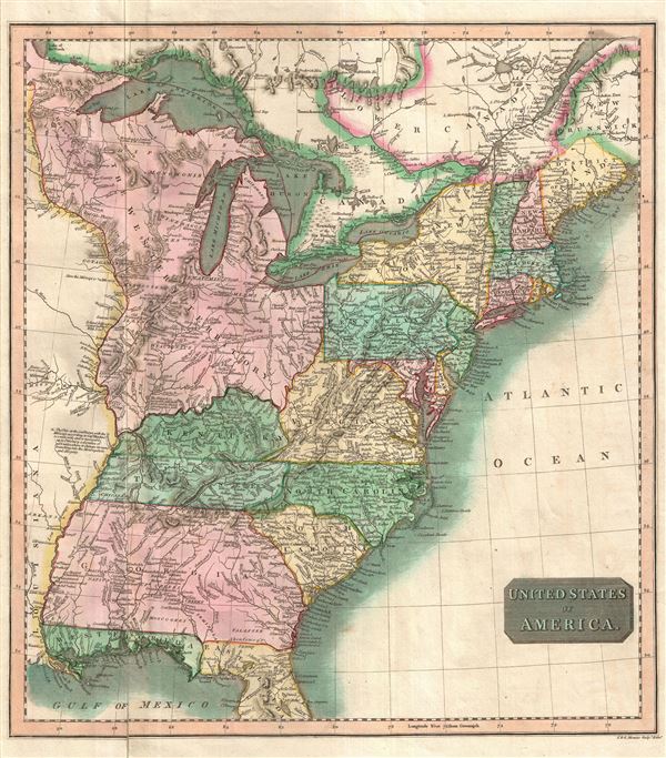
1814 Thomson Map of the United States and St. Lawrence River
1814 (undated) $500.00
1814 Thomson Map of the United States
UnitedStates2-thomson-1814$200.00

Title
United States of America.
1814 (undated) 16.5 x 14.75 in (41.91 x 37.465 cm) 1 : 5950000
1814 (undated) 16.5 x 14.75 in (41.91 x 37.465 cm) 1 : 5950000
Description
A particularly bright and beautiful example of John Thomson's important 1814 map of the United States. The map focuses on the United States from the Mississippi River eastward to the Atlantic including the Great Lakes and adjacent parts of Ontario, Quebec, and Louisiana. The map shows an early statehood configuration with Georgia extending westward as far as the Mississippi including all of modern day Alabama, Florida divided into eastern and western zones, and the Great Lakes region controlled by the Northwest Ordinance.
Florida is depicted according to an ephemeral division into eastern and western zones. This configuration emerged around 1810 when President James Madison annexed western Florida from Spain claiming it as part of the Louisiana Purchase. Though somewhat spurious, Madison's claim allowed the United States to take control of Mobile Bay thus opening an important artery into the interior of modern day Alabama to America traders and settlers. East Florida was, at this time, still under Spanish control and would remain so until the Adams-Onis Treaty of 1821.
All of the territory between the Ohio River, the Great Lakes, and the Mississippi is rendered as the Northwest Territory. The Northwest Territory was created in 1789 by the Northwest Ordinance. The Ordinance, which some call the Freedom Act, is considered to be the single most important act of legislation passed by the Continental Congress after the Declaration of Independence. Through the Northwest Territory, the Continental Congress established the conventions upon which the United States would expand westward. By consolidating sole distribution rights for all westward land sales into the hands of the federal government, the Congress established a president that would in the course of the next 50 years, weaken the power of the individual states while simultaneously strengthening the centralized federal government.
In what would become Ohio, there is an unusual boundary line labeled 'Boundary Line by the Treaty of 1795.' This refers to the Treaty of Greenville. On August 20, 1794, an American army commanded by Anthony Wayne defeated a Native American force led by Blue Jacket of the Shawnee at the Battle of Fallen Timbers. The treaty that followed established United States hegemony over the region, forcing the American Indian nations to relinquish all claims to land south and east of a boundary that began roughly at the mouth of the Cuyahoga River, then turned southward to Fort Laurens, and then westward to Fort Loramie and Fort Recovery, then finally southward to the Ohio River. The whites, in turn, relinquished claims to the territory north and west of the line. This was a short lived concession and rarely appears on maps.
Throughout this map, considerable attention is given to the naming of veracious American Indian Nations, including the Muscogee, Creek, Choctaw, Chippewa, Miami, Illinois, and others. There are several notations along the Mississippi and Ohio commenting the practicality of navigation and trade along the rivers.
This is the first edition of Thomson's map from the 1814 edition of the General Atlas. Subsequent editions were published in 1817 and 1826.
Cartographer
John Thomson (1777 - c. 1841) was a Scottish cartographer, publisher, and bookbinder active in Edinburgh during the early part of the 19th century. Thomson apprenticed under Edinburgh bookbinder Robert Alison. After his apprenticeship, he briefly went into business with Abraham Thomson. Later, the two parted ways, John Thomson segueing into maps and Abraham Thomson taking over the bookbinding portion of the business. Thomson is generally one of the leading publishers in the Edinburgh school of cartography, which flourished from roughly 1800 to 1830. Thomson and his contemporaries (Pinkerton and Cary) redefined European cartography by abandoning typical 18th-century decorative elements such as elaborate title cartouches and fantastic beasts in favor of detail and accuracy. Thomson's principle works include Thomson's New General Atlas, published from 1814 to 1821, the New Classical and Historical Atlas of 1829, and his 1830 Atlas of Scotland. The Atlas of Scotland, a work of groundbreaking detail and dedication, would eventually bankrupt the Thomson firm in 1830, at which time their plates were sequestered by the court. The firm partially recovered in the subsequent year, allowing Thomson to reclaim his printing plates in 1831, but filed again for bankruptcy in 1835, at which time most of his printing plates were sold to A. K. Johnston and Company. There is some suggestion that he continued to work as a bookbinder until 1841. Today, Thomson maps are becoming increasingly rare as they are highly admired for their impressive size, vivid hand coloration, and superb detail. More by this mapmaker...
Source
Thomson, J. A New General Atlas, (Edinburgh) 1814.
Condition
Very good. Lower left quadrant exhibits minor wear and verso repair.
References
Rumsey 1007.061 (1817 edition). Newberry Library: Ayer 135 T4 1817 no. 55.