
1862 Colton Map of the United States during the Civil War

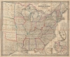
G. Woolworth Colton's New Guide Map of the United States and Canada, with Railroads, Counties etc.
Snapshot of a rapidly changing country.
- Digital Map Information
- Suitable for large format printing
- File Size: 1436.73 MB
- File Type: ZIP / TIFF
- ICC color profile embedded
- Delivered instantly via download link
Snapshot of a rapidly changing country.
An impressive 1862 folding map of the United States by George Woolworth Colton, heir of the prominent map publishing firm founded by his father Joseph Hutchins Colton. Remarkably detailed, it highlights railroads, state / territory and county lines, and demographic data at the height of the American Civil War (1861 - 1865).A Closer Look
Though published during the U.S. Civil War, the map retains the country's pre-war boundaries; thus, there is no indication of the Confederacy (or perhaps it reflects Colton's Union loyalties?). It does, however, denote the Nevada, Dakota, and Colorado Territories, all created on the eve of the conflict. During the war, the territories of Idaho, Montana, and Arizona would be organized, significantly altering the western United States.Railroads, rivers, mountains, towns and cities, and county lines are noted throughout, in addition to state and territory borders. Inset maps at bottom-right cover the southern portions of Florida and Texas as well as the western U.S. Tables provide the populations of cities with more than 10,000 inhabitants as well as the total population of the states and territories. Both Greenwich and Washington, D.C. are employed as prime meridians.
Publication History and Census
This map is one of several published in 1862 under 'G. Woolworth Colton' instead of 'J. H. Colton' or simply 'Colton.' G. W. Colton appears to have established his own firm briefly in that year after J. H. Colton ceased publications, but the latter firm reappeared later in 1862 and G. W. Colton ceased to function independently. That being said, maps with the title 'Colton's New Guide Map Of The United States and Canada' were published by the Coltons with some regularity through the 1860s, apparently in small runs as they are now rare in institutional collections. The present map is cataloged among the holdings of the Minnesota Historical Society, the University of Illinois-Urbana Champaign, Harvard University, Yale University, Cornell University (seemingly with the dimensions miscataloged), Stanford University, the New York Public Library, Brigham Young University, and the Bibliothèque nationale de France. The Library of Congress holds a modified edition (call number G3701.S5 1862 .C6) with Union military departments superimposed over state borders.Cartographers
Joseph Hutchins Colton (July 5, 1800 - July 29, 1893), often publishing as J. H. Colton, was an important American map and atlas publisher active from 1833 to 1897. Colton's firm arose from humble beginnings when he moved to New York in 1831 and befriended the established engraver, Samuel Stiles. He worked under Stiles as the 'Co.' in Stiles and Co. from 1833 to 1836. Colton quickly recognized an emerging market in railroad maps and immigrant guides. Not a cartographer or engraver himself, Colton's initial business practice mostly involved purchasing the copyrights of other cartographers, most notably David H. Burr, and reissuing them with updated engraving and border work. His first maps, produced in 1833, were based on earlier Burr maps and depicted New York State and New York City. Between 1833 and 1855, Colton proceeded to publish a large corpus of guidebooks and railroad maps, which proved popular. In the early 1850s, Colton brought his two sons, George Woolworth Colton (1827 - 1901) and Charles B. Colton (1832 - 1916), into the map business. G. W. Colton, trained as a cartographer and engraver, was particularly inspired by the idea of creating a large and detailed world atlas to compete with established European firms for the U.S. market. In 1855, G.W. Colton issued volume one of the impressive two-volume Colton's Atlas of the World. Volume two followed a year later. Possibly because of the expense of purchasing a two-volume atlas set, the sales of the Atlas of the World did not meet Colton's expectations, and so, in 1856, the firm also issued the atlas as a single volume. The maps contained in this superb work were all original engravings, and most bear an 1855 copyright. All of the maps were surrounded by an attractive spiral motif border that would become a hallmark of Colton's atlas maps well into the 1880s. In 1857, the slightly smaller Colton's General Atlas replaced the Atlas of the World. Most early editions of the General Atlas published from 1857 to 1859 do not have the trademark Colton spiral border, which was removed to allow the maps to fit into a smaller format volume. Their customers must have missed the border because it was reinstated in 1860 and remained in all subsequent publications of the atlas. There were also darker times ahead; in 1858, Colton was commissioned at a sum of 25,000 USD by the government of Bolivia to produce and deliver 10,000 copies of a large format map of that country. Although Colton completed the contract in good faith, delivering the maps at his own expense, he was never paid by Bolivia, which was at the time in the midst of a series of national revolutions. Colton would spend the remainder of his days fighting with the Bolivian and Peruvian governments over this payment, and in the end, after a congressional intervention, he received as much as 100,000 USD in compensation. Nonetheless, at the time, it was a disastrous blow. J. H. Colton and Company is listed as one of New York's failed companies in the postal record of 1859. This led Colton into the arms of Alvin Jewett Johnson and Ross C. Browning. The 1859 edition of Colton's General Atlas lists Johnson and Browning as the 'Successor's to J. H. Colton' suggesting an outright buyout, but given that both companies continued to publish separately, the reality is likely more complex. Whatever the case may have been, this arrangement gave Johnson and Browning access to many of Colton's map plates and gave birth to Johnson's New Illustrated (Steel Plate) Family Atlas. The Johnson's Atlas was published parallel to Colton's atlases well into the 1880s. The Colton firm itself subsequently published several other atlases including an Atlas of America, the Illustrated Cabinet Atlas, the Octavo Atlas of the Union, and Colton's Quarto Atlas of the World. They also published a large corpus of wall maps, pocket maps, and guides. The last known publications of the Colton firm date to 1897 and include a map and a view, both issued in association with the Merchant's Association of New York. Alice M. Colton married August R. Ohman (May 3, 1859 - April 22, 1934) on January 5, 1897. In 1898, Ohman joined the Colton firm, which continued to publish as Colton, Ohman & Co. until 1901. Further Details...
Rufus Blanchard Evanston (March 7, 1821 - January 3, 1904) was an American photographer, mapmaker, publisher, viewmaker, bookseller, and publisher active in Chicago in the second half of the 19th century. Blanchard was born in Lyndeborough, New Hampshire. He studied at Ipswich Academy, where he showed proficiency in Latin and Mathematics. He moved to New York in 1835 to live with his brother, Calvin Blanchard, who ran a bookstore at 78 Nassau St. He witnessed both the New York Fire of 1835 and the Wall Street bank panic of 1836. Perhaps believing civilization was doomed, he moved to the backwoods of Ohio, where he spent three years bushwhacking, hunting, and trapping. Returning to New York in 1840, Blanchard worked for the Harper Brothers publishing house. The publishing business suited Blanchard, leading to his relocation to Lowell, Massachusetts in 1843 to open a bookshop. This business lasted just 3 years before the restless young man moved again, this time to Cincinnati, where he opened another shop with his brother Edwin Blanchard. After some success, he established an annex office in New Orleans. The Cholera epidemic of 1847-1848, followed by the great fire of St. Louis, unfortunately, devastated his interests in the region. He moved back to New York in 1849, briefly establishing a printing concern with Charles Morse, son of the famous inventor, and working with the J. H. Colton firm. He relocated to Chicago sometime before 1853, when he established himself there as a printer and publisher. He relocated his business to the railroad hub of Chicago (52 LaSalle Street) in 1854 to capitalize on the national need for good railroad maps. In 1857, he published Chicago's first street guide. In addition to his Chicago business, he also had an office in Wheaton, Illinois. His nephew, George Cram (1842 - 1928), joined his business in 1867, after being discharged from the Union Army, and they rebranded as 'Blanchard and Cram.' Both 'Blanchard and Cram' of Chicago and the Wheaton businesses were destroyed in 1871 - the main business by the Great Chicago Fire, and the Wheaton office in a smaller fire. Nonetheless, Blanchard persevered and rebuilt both enterprises, though without Cram, who established his own firm, the George F. Cram and Company. In 1885, fire again destroyed his business, and he lost much of his map stock, but he persevered and rebuilt. Blanchard's personal life mirrored the highs and lows of his business life. He first married Permilla Far (1829 - 1857) in 1856. On their honeymoon, Permilla was severely injured and died shortly thereafter, in 1857, from related complications. He remarried in 1858 to Anna E. Hall (1842 - 1925). Blanchard lived to 83, and during the entire time, continued to actively photograph, write, and publish. It is said that he 'never grew old in heart or brain.' Further Details...
Condition
Good. Some spotting. Verso reinforcement and some repairs at fold intersections. Accompanies original binder.
References
OCLC 10034030, 953568986, 63614889, 1323688001, 367493328, 494807868.