This item has been sold, but you can get on the Waitlist to be notified if another example becomes available, or purchase a digital scan.
1810 Pinkerton Map of the United States (Northeast)
UnitedStatesNE-pinkerton-1810$300.00

Title
United States of America Northern Part.
1810 (dated) 20 x 27.5 in (50.8 x 69.85 cm) 1 : 2100000
1810 (dated) 20 x 27.5 in (50.8 x 69.85 cm) 1 : 2100000
Description
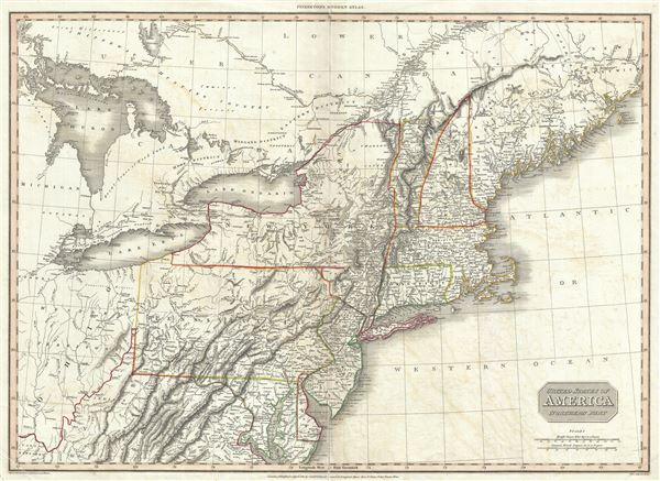
A rare and important 1810 map of the northeastern part of the United States by John Pinkerton. The map covers from Lake Huron and Ohio, extending north as far as Canada and Maine, and south to the Chesapeake Bay and northern Kentucky. The states of New York, Pennsylvania, Maryland, Delaware, New Jersey, Connecticut, Massachusetts, New Hampshire, Rhode Island, and Vermont are illustrated in full. Ohio and Michigan are collectively identified as the Western Territory and are partially included. The Great Lakes Ontario, Erie, and Huron and represented fully.
Maine, identified here as the 'District of Maine,' is given the ambiguous borders associated with the 1783 Treaty of Paris as the end of the American Revolutionary War. As might be expected, Pinkerton's postcolonial sympathies lay heavily with British interests and Maine is here presented as more attached to Canada than the United States. From an American perspective, Maine was considered to be an extension of Massachusetts. In fact, the entire district was sparsely inhabited except along the coast, which was generally lawless and a haven for illegal smuggling and trade between the British Provinces in Canada and the United States. Just two years after this map was made the War of 1812 broke out. The War of 1812 arose over various unresolved issues associated with the American Revolutionary War, including some associated with the Maine border. During the war the British were exceptionally aggressive in this region and seized most of the Maine coastline. It was not returned to the United States until the 1815 Treaty of Ghent.
This map was created during the transitional period of expansion shortly following the American Revolutionary War. As such this is one of the few maps to specifically depict the Connecticut Western Reserve in what is today northeastern Ohio. The Connecticut Reserve is a remnant of Connecticut's original colonial era coast to coast charter. Following the Yankee-Pennamite Wars, Connecticut was forced to surrender the Pennsylvania portions of the charter; however, it retained some lands to the west of Pennsylvnaia and north of the 41st parallel. Connecticut later surrendered these claims in exchange for federal assumptions of its Revolutionary War debt.
Drawn by L. Herbert and engraved by Samuel Neele under the direction of John Pinkerton. Published in London by 'Cadell and Davies' and 'Longman Hurst Ress & Ormes' for John Pinkerton's
Cartographer
John Pinkerton (February 17, 1758 - March 10, 1826) was an Scottish writer, historian, and cartographer. Pinkerton was born in Edinburgh, Scotland. He was a studious youth with a passion for the classics. As a young man, he studied at Edinburgh University before apprenticing as a lawyer. Around this time, he began writing, with his first book, Elegy on Craigmillar Castle published in 1776. Pinkerton moved to London in 1781 to pursue his writing career in earnest. He successfully published several works of literature, poetry, and history. Pinkerton proved passionate in his literary and historical writings, but his correspondence with other cartographers has been labeled as aggressive, even insane. In addition to his work as a writer and historian, Pinkerton was one of the leading masters of the Edinburgh school of cartography which flourished from roughly 1800 to 1830. Pinkerton and his contemporaries (Thomson and Cary) redefined European cartography by abandoning typical 18th century decorative elements such as elaborate title cartouches and fantastical beasts in favor of detail and accuracy. Pinkerton's principle work is Pinkerton's Modern Atlas published from 1808 through 1815 with a special American reissue by Dobson and Co. in 1818. Pinkerton relocated to Paris in 1818, where he managed his publishing business until his death in 1826. More by this mapmaker...
Source
Pinkerton, John, A modern atlas, from the latest and best authorities, exhibiting the various divisions of the world, with its chief empires, kingdoms and states, in sixty maps, carefully reduced from the largest and most authentic sources, (London: Cadell & Davies, Longman Hurst Rees, & Orme) 1811.
Condition
Very good. Original centerfold exhibits some wear and verso reinforcement. Offsetting throughout. Blank on verso.